|
CAPTAIN ACCURATE'S WEATHER
TIMELINE |

|


|
Graphical view of the Middle Tennessee Tornadoes https://www.weather.gov/ohx/20200303 It's not easy being Accurate #CaptAccurateWx LOW this morning in Knoxville: 42° Knoxville's normal LOW this time of year: 37° Knoxville's normal HIGH this time of year: 58° Today: Partly sunny, breezy, gusts 30-35 mph, spots of rain drop down from the North and change to snowflakes, especially for the Smokies and S.E. Kentucky, 40% chance, daytime highs in the lower to mid 40s Tonight: Mostly cloudy, isolated flurries for the Smokies, colder, lows near 30° Saturday: Early morning clouds, becoming sunny, highs in the lower 50s Saturday night: Starry skies, lows in the lower 30s Sunday: Mostly sunny, highs in the lower 60s Sunday night: Mostly clear, lows in the upper 30s Monday: Partly cloudy, 20% chance of spotty rain at night, highs in the mid 60s For the latest 7 Day Forecast for Oliver Springs, Norma, Washburn or your town, check out the Captain Accurate Weather App. I also have a BRAND NEW horizontal 7 Day Forecast for Knoxville and a BRAND NEW Video, posted daily, on the home page of CaptainAccurate.com and on the Captain Accurate Weather App. Check it out here. All forecasts are not created equal #CaptAccurateWx P.S. If you find these independent forecasts and posts helpful, please consider supporting me by downloading my NEW Captain Accurate Weather App. It's FREE. Just search: Captain Accurate at the App Store and Google Play. It comes with 5 FREE App Tutorials, so you can quickly learn all the wonderful things it can do. National Weather Service Morristown TN 321 PM EST Thu Mar 5 2020 Johnson-Cocke Smoky Mountains-Southeast Greene-Unicoi- Southeast Carter-Blount Smoky Mountains-Sevier Smoky Mountains- Southeast Monroe- Including the cities of Doeville, Mountain City, Neva, Shady Valley, Trade, Laurel Bloomery, Hartford, Cedar Creek, Erwin, Unicoi, Limestone Cove, Hampton, Cades Cove, Elkmont, Gatlinburg, Citico, and Coker Creek 321 PM EST Thu Mar 5 2020 ...WINTER WEATHER ADVISORY IN EFFECT FROM 1 AM FRIDAY TO 10 AM EST SATURDAY... WHAT...Snow expected. Total snow accumulations of up to 4 inches. Winds gusting as high as 35 mph. WHERE...Portions of east Tennessee. WHEN...From 1 AM Friday to 10 AM EST Saturday. IMPACTS...Plan on slippery road conditions. The hazardous conditions could impact the morning or evening commute. ADDITIONAL DETAILS...Wind chill values will drop into lower teens and single digits across the higher elevations tonight and Friday. PRECAUTIONARY/PREPAREDNESS ACTIONS... Slow down and use caution while traveling. The latest road conditions for the state you are calling from can be obtained by calling 5 1 1. 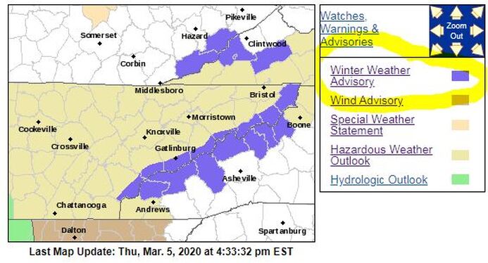 From NWS-Morristown
2 Comments
Terry in Harlan KY
3/5/2020 04:58:51 pm
Although it probably want stick down low in the valley areas, Harlan is under a Winter Weather Advisory. Near 70 next week with more storms and heavy rain...have to love March, lol. Leave a Reply. |
David AldrichCaptain Accurate Weather Archives
July 2024
Categories |


 RSS Feed