|
CAPTAIN ACCURATE'S WEATHER
BLOG |

|


 From NWS-Morristown Tonight: Mostly clear, chilly, lows in the lower 30s Normal low for this time of year: 29° Sunrise 7:46 AM Wednesday: Wall to wall sunshine, highs in the lower to mid 50s. Normal high for this time of year: 47° Sunset 5:39 PM Wednesday night: Mostly clear, lows in the lower 30s Thursday: Hazy sun with increasing high clouds, warmer, high in the upper 50s to around 60° Thursday night: More clouds, mild, lows in the mid 40s and RISING Friday: Hazy sun and clouds, spotty rain late, 20% chance, highs in the upper 60s Friday night: Rain showers, 60% chance, mild, lows in the mid 50s Saturday: Cloudy, periods of rain, heavy at times, 80% chance, isolated storms, warm wind, highs around 70°. Knoxville's Record high on Saturday is in play: 72° (1890). Saturday night: Rainy at times, 80% chance, isolated thunder, lows in the mid 40s Sunday: Bright sunshine, highs in the mid 60s ***Turning RAINY for late Friday and especially Saturday, but drying out for Sunday*** Today's model runs suggest: Model A...2.05" Model B...0.90" 2 Model Average: 1.47" of potential rain late Friday into Saturday with localized flooding potential. The value of a forecast is not just what you say, but when you say it #CaptAccurateWx P.S. If you find these independent forecasts and posts helpful, please consider downloading my NEW Captain Accurate Weather App. It's FREE. Just search: Captain Accurate at the App Store and Google Play. It comes with 5 FREE App Tutorials, so you can quickly learn all the wonderful things it can do.
0 Comments
 From NWS-Morristown Expect about a quarter inch of rain for much of East Tennessee later tonight. Some snow (flurries to 0.5") may mix in from Morristown EAST to Rogersville to the Tri-Cities, near and along the TN / KY state line and if you're traveling throughout Southeast Kentucky. Future rainfall tonight (after midnight) Model A...0.33" Model B...0.21" Model C...0.32" 3 Model average: 0.286" Looking ahead to NEXT Friday into Saturday...RAIN develops, as it warms up into the 60s to near 70 and dries out on Sunday. Model A...1.05" Model B...0.80" 2 Model average: 0.925"....which is a BIG drop from yesterday's data of over 2" So weather does not surprise you #CaptAccurateWx P.S. If you find these independent forecasts and posts helpful, please consider downloading my NEW Captain Accurate Weather App. It's FREE. Just search: Captain Accurate at the App Store and Google Play. It comes with 5 FREE App Tutorials, so you can quickly learn all the wonderful things it can do.
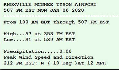
 From NWS-Morristown The next chance of rain arrives late Monday night (after midnight) and into Tuesday morning. How much? About a quarter inch of rain on average. Model A...0.32" Model B...0.24" Model C...0.20" 3 Model Average: 0.253" Tonight: Mostly clear with some scattered clouds late, chilly, lows in the lower 30s Normal low for this time of year: 29° Sunrise 7:47 AM Monday: Mostly sunny, highs in the lower to mid 50s Normal high for this time of year: 47° Sunset 5:37 PM Monday night: Increasing clouds, rain showers after midnight, 60% chance, lows in the upper 30s to near 40° Tuesday: Morning rain showers, 40% chance, clouds to some sun, highs in the upper 40s to near 50° Tuesday night: Decreasing clouds, chilly, lows in the lower 30s Wednesday: Sunshiny skies, highs in the lower 50s Wednesday night: Mostly clear, lows in the lower 30s Thursday: Mostly sunny, more clouds late and warmer, highs in the upper 50s ***Turning RAINY for Friday and especially Saturday, but drying out for Sunday*** Early model runs suggest: Model A...1.81" Model B...2.95" 2 Model Average: 2.38" of potential rain Friday into Saturday. The value of a forecast is not just what you say, but when you say it #CaptAccurateWx P.S. If you find these independent forecasts and posts helpful, please consider downloading my NEW Captain Accurate Weather App. It's FREE. Just search: Captain Accurate at the App Store and Google Play. It comes with 5 FREE App Tutorials, so you can quickly learn all the wonderful things it can do.
The framework has NOT changed, as far as locations that get snow. I have given more snow expectations to the Smokies in the HIGHER elevations above 3,000 feet, (3" +, possibly 4", as this could impact travel), while giving less snow for the Plateau (0.5" or less, emphasis on LESS). Keep in mind, these are snow showers that will be falling (NOT a snow storm) and snowflakes will NOT be evenly distributed. In the Valley, nothing has changed. Expect very little if ANYTHING for the Valley. Psst! It's the Horseshoe Effect. Colder air in the higher hills give you more to work with in terms of snowfall there. Sorry, Valley. There will be other chances. Winter is just getting started. To see my Winter Weather Outlook, go to the Home page of CaptainAccurate.com. Scroll down a bit and just hit PLAY. It's just as relevant today as when I posted it on November 5th. For more details on your weekend forecast, click here: http://www.captainaccurate.com/blog/your-first-2020-weekend-beyond-forecast *** For what it's worth, bright sunshine on Sunday should make for BEAUTIFUL picture taking opportunities in or near the Smokies after a fresh snow has fallen there. It's not easy being Accurate #CaptAccurateWx 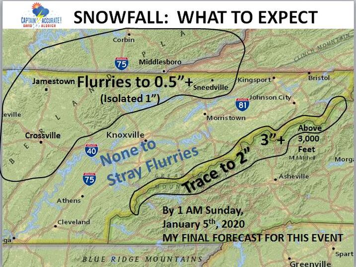 P.S. If you find these independent forecasts and posts helpful, please consider downloading my NEW Captain Accurate Weather App. It's FREE. Just search: Captain Accurate at the App Store and Google Play. It comes with 5 FREE App Tutorials, so you can quickly learn all the wonderful things it can do.
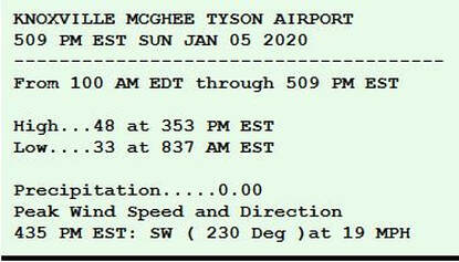
Rain will continue to fall at times in East Tennessee today and tonight and even on Saturday. But by midday Saturday, temperatures will fall quickly enough, providing a changeover to snow for the Plateau and eventually the Smokies. Expect very little if ANYTHING for the Valley. Psst! It's the Horseshoe Effect. Colder air in the higher hills give you more to work with in terms of snowfall there. Sorry, Valley. There will be other chances. Winter is just getting started. To see my Winter Weather Outlook, go to the Home page of CaptainAccurate.com. Scroll down a bit and just hit PLAY. It's just as relevant today as when I posted it on November 5th. For more details on your weekend forecast, click here: http://www.captainaccurate.com/blog/your-first-2020-weekend-beyond-forecast It's not easy being Accurate #CaptAccurateWx 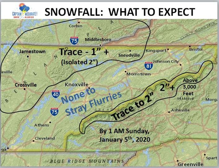 P.S. If you find these independent forecasts and posts helpful, please consider downloading my NEW Captain Accurate Weather App. It's FREE. Just search: Captain Accurate at the App Store and Google Play. It comes with 5 FREE App Tutorials, so you can quickly learn all the wonderful things it can do.
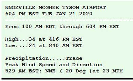
Congratulations to the Tennessee Volunteers! TaxSlayer Gator Bowl 2020 Champions!!! Sunrise 7:46 AM Today: Rainy at times, cloudy, 80% chance, highs in the mid to upper 50s. Sunset 5:34 PM Tonight: More showers, steady at times, 80% chance, fog, lows near 50°. Saturday: Mostly cloudy, rain showers, 60% chance, gusts around 30 mph in the Valley, early daytime highs in the lower 50s and FALLING into the 40s and then 30s by the afternoon. By midday Saturday, the Plateau may receive a trace to 0.5"+ of snow in spots. Don't expect much of anything in terms of snow for Knoxville and the Valley. Smokies, however, could pick up an inch of snow or more by Saturday night. (Psst! Horseshoe Effect) Saturday night: Decreasing clouds, light rain and drizzle ending with some flurries, 20% chance, COLDER, lows near 32°. Sunday: Mostly sunny, highs in the upper 40s. Sunday night: Mostly clear, lows in the lower 30s. Monday: Mostly sunny, highs in the lower 50s. The value of a forecast is not just what you say, but when you say it #CaptAccurateWx P.S. If you find these independent forecasts and posts helpful, please consider downloading my NEW Captain Accurate Weather App. It's FREE. Just search: Captain Accurate at the App Store and Google Play. It comes with 5 FREE App Tutorials, so you can quickly learn all the wonderful things it can do.
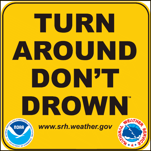
 From NWS-Morristown Rainfall amounts for East Tennessee from Today through Saturday: 1-3"+ with locally higher amounts. Localized flooding could be an issue. Turn Around, Don't Drown! NEW Thursday model data Model A...2.80" Model B...2.72" Model C...1.95" 3 Model Average: 2.49" Sunset 5:34 PM Tonight: Cloudy, periods of heavy rain, 100% chance, lows in the lower to mid 40s and RISING to near 50° around sunrise. Friday: Rainy, cloudy, 80% chance, highs near 60°. Friday night: More rain, steady at times, 80% chance, lows near 50°. Saturday: Mostly cloudy, rain showers, 60% chance, gusts around 30 mph in the Valley, early daytime highs in the lower 50s and FALLING into the 40s and then 30s by the afternoon. Saturday night: Decreasing clouds, light rain and drizzle ending with some flurries, 20% chance, COLDER, lows in the upper 20s. Sunday: Mostly sunny, highs in the upper 40s. Sunday night: Starry skies, lows in the lower 30s. Monday: Mostly sunny, highs in the lower 50s. So weather does not surprise you #CaptAccurateWx P.S. If you find these independent forecasts and posts helpful, please consider downloading my NEW Captain Accurate Weather App. It's FREE. Just search: Captain Accurate at the App Store and Google Play. It comes with 5 FREE App Tutorials, so you can quickly learn all the wonderful things it can do.
Hello Rainy Season. Are you READY? Rainfall amounts for East Tennessee from Today to Saturday: 1-3"+ with locally higher amounts. Localized flooding could be an issue. Turn Around, Don't Drown! NEW model data Model A...3.09" Model B...1.86" Model C...2.19" 3 Model Average: 2.38" Today: Sunrise 7:46 AM Cloudy skies, turning rainy, 100% chance, highs in the upper 40s to near 50. Temperatures may rise even after dark. Sunset 5:34 PM Thursday night: Cloudy, more showers, 100% chance, lows in the mid 40s and RISING. Friday: Cloudy, rain showers, 80% chance, highs near 60°. Friday night: More rain, steady at times, 80% chance, lows near 50°. Saturday: Mostly cloudy, rain showers, 60% chance, windy, gusts around 30 mph in the Valley, early highs in the lower 50s and FALLING into the 40s and then 30s. Saturday night: Decreasing clouds, drizzle or stray flurries, 20% chance, COLDER, lows in the upper 20s. Sunday: Mostly sunny, highs in the upper 40s. Sunday night: Starry skies, lows in the lower 30s. Monday: Mostly sunny, highs in the lower 50s. It's not easy being Accurate #CaptAccurateWx P.S. If you find these independent forecasts and posts helpful, please consider downloading my NEW Captain Accurate Weather App. It's FREE. Just search: Captain Accurate at the App Store and Google Play. It comes with 5 FREE App Tutorials, so you can quickly learn all the wonderful things it can do.  It's FREE. Just search: Captain Accurate at the App Store and Google Play.   From NWS-Morristown The LATEST on the RAIN for Thursday, Friday & Saturday Localized flooding could be an issue. Turn Around, Don't Drown! Model A...1.80"...ends with 0.5" of snow or LESS falling with even less actually sticking Model B...3.14"...ends with 0.5" of snow or LESS falling with even less actually sticking Model C...1.42"...ends with 0.5" of snow or LESS falling with even less actually sticking 3 Model Average: 2.12"..ends with 0.5" of snow or LESS falling with even less actually sticking For Knoxville and the Valley: Some sprinkles toward sunrise Thursday will be possible, but 10 AM to NOON is a reasonable start time for the steadier rain to begin. By midday Saturday, temperatures will be dropping fast. This is consistent with what Captain Accurate wrote just after 2 PM on December 31st: "Rain develops on Thursday...turning moderate to heavy. Periods of heavy rain Friday. Heavier rain Friday night with downpours, potentially. Localized flooding could be an issue. Rainfall amounts from Thursday to Saturday: 1-3"+ with locally higher amounts Mostly cloudy Saturday, rain showers that could end as snow showers by Saturday evening. Snow Trend: 0.5" or less of snow may fall, but even less may stick." Higher amounts for the Smokies, of course. #CaptAccurateWx P.S. If you find these independent forecasts and posts helpful, please consider downloading my NEW Captain Accurate Weather App. It's FREE. Just search: Captain Accurate at the App Store and Google Play. It comes with 5 FREE App Tutorials, so you can quickly learn all the wonderful things it can do. It's FREE. Just search: Captain Accurate at the App Store and Google Play.  |
David AldrichCaptain Accurate Weather Archives
April 2024
Categories |


 RSS Feed