|
CAPTAIN ACCURATE'S WEATHER
BLOG |

|


|
FEBRUARY RAINFALL SO FAR... 9.35" Normal for the month of February: 4.26" Tonight: More clouds, lows in the mid 30s Sunday: Mostly cloudy, some P.M. sprinkles possible, highs in the mid 50s Sunday night: Mostly cloudy, lows in the upper 30s Monday / Presidents Day: Mix of clouds and sun, highs in the lower 60s Monday night: Clouds thicken, lows in the upper 40s to near 50° Tuesday: Cloudy, periods of rain, about a half inch or less, warm highs in the mid to upper 60s For the latest 7 Day Forecast for your town, check out the Captain Accurate Weather App. I also have a BRAND NEW horizontal 7 Day Forecast for Knoxville and a BRAND NEW Video, posted daily, on the home page of CaptainAccurate.com and on the Captain Accurate Weather App. Check it out here. When your forecast matters #CaptAccurateWx P.S. If you find these independent forecasts and posts helpful, please consider supporting me by downloading my NEW Captain Accurate Weather App. It's FREE. Just search: Captain Accurate at the App Store and Google Play. It comes with 5 FREE App Tutorials, so you can quickly learn all the wonderful things it can do.
0 Comments
Happy Valentine's Day ! :-) 2 Riddles from Captain Accurate. 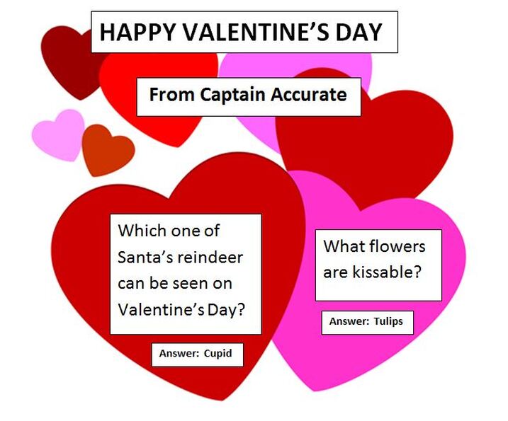 Updated 8:40 AM Friday Finally a change in the weather pattern will give us some sunshine the couple of days. Enjoy ! --- Captain Accurate RAINY RECAP from this WEEK: McGhee Tyson Airport Monday...0.92" Tuesday...1.24" Wednesday...0.48" Today...0.82" TOTAL RAINFALL THIS WEEK: 3.46" This falls in line with my Sunday prediction of 3" to 4" of rain with isolated 5" amounts. It's not easy being Accurate #CaptAccurateWx Today / Valentine's Day: Becoming mostly sunny, cold, highs in the lower 40s Friday night / Valentine's Day night: Starry skies and frosty cold, lows in the lower 20s Saturday: Mostly sunny, milder in the afternoon, highs in the lower 50s Saturday night: Increasing clouds, lows in the mid 30s Sunday: Mostly cloudy, highs in the mid 50s Sunday night: Mostly cloudy, lows in the upper 30s Monday / Presidents Day: Mix of clouds and sun, spotty rain late, 20% chance Highs in the lower 60s For the latest 7 Day Forecast for your town or location, check out the Captain Accurate Weather App. I also have a BRAND NEW horizontal 7 Day Forecast for Knoxville and a BRAND NEW Video, posted daily, on the home page of CaptainAccurate.com and on the Captain Accurate Weather App. Check it out here. When your forecast matters #CaptAccurateWx P.S. If you find these independent forecasts and posts helpful, please consider supporting me by downloading my NEW Captain Accurate Weather App. It's FREE. Just search: Captain Accurate at the App Store and Google Play. It comes with 5 FREE App Tutorials, so you can quickly learn all the wonderful things it can do.
When you wake up Thursday morning, the rapid drop in temperature will have already started, as Knoxville falls through 50s Thursday morning and falls through the 40s Thursday afternoon. --- Captain Accurate FLASH FLOOD WATCH has been extended until 10 AM this morning by the National Weather Service in Morristown. Today: Periods of rain, mostly in the morning, 80% chance, gusty winds, early pre-dawn highs in the 60s with daytime highs FALLING through the 50s and 40s. Tonight: Mostly cloudy, turning sharply colder, lows in the mid 20s. Friday / Valentine's Day: Mostly sunny, cold, highs in the lower 40s Friday night / Valentine's Day night: Mostly clear, some high clouds and cold, lows in the lower 20s Saturday: Mostly sunny, milder in the afternoon, highs in the lower 50s Saturday night: Increasing clouds, lows in the mid 30s Sunday: Mostly cloudy, some sprinkles may develop in the afternoon for the Plateau, highs in the lower to mid 50s For the latest 7 Day Forecast for your town or location, check out the Captain Accurate Weather App. I also have a BRAND NEW horizontal 7 Day Forecast for Knoxville and a BRAND NEW Video, posted daily, on the home page of CaptainAccurate.com and on the Captain Accurate Weather App. Check it out here. When your forecast matters #CaptAccurateWx P.S. If you find these independent forecasts and posts helpful, please consider supporting me by downloading my NEW Captain Accurate Weather App. It's FREE. Just search: Captain Accurate at the App Store and Google Play. It comes with 5 FREE App Tutorials, so you can quickly learn all the wonderful things it can do.
Heavy rain and gusty winds will develop later Tonight into Thursday morning. I am expecting roughly 1 to 1.5 inches of rain with isolated 2" amounts to fall during that timeframe. Time to watch for Knoxville (Valley) and the Smokies: 1 AM to 8 AM Thursday Expect the gusty downpours to arrive in the Plateau several hours sooner...and ending several hours sooner. ***TURN AROUND, DON'T DROWN ! *** Meanwhile, NWS issued a High Wind Warning for the Smokies that runs from 1 PM Today to 7 AM Thursday for South winds 25 to 40 mph with gusts up to 70 mph. *** TOTAL RAINFALL that I am expecting THIS WEEK: 3 to 4" of rain with isolated 5" + amounts when you add up Monday's rain, plus Tuesdays's rain, plus what we get Today, plus Thursday of this week. *** LAST WEEK, Knoxville received 5.63" of rain from Tuesday to Thursday. McGhee Tyson Airport so far this week. Monday: 0.92" Yesterday (Tuesday): 1.24" Today, as of 8 AM, so far... Trace TOTAL since Monday: 2.16" Knoxville Today: Low this morning: 44° Rainfall today, as of 8 AM: Trace Today: Mainly gray, few showers, 40% chance, highs in the upper 50s to lower 60s Tonight: Rain showers and wind increase, 100% chance of rain, gusty downpours late, isolated thunder, Valley gusts around 30 to 40 mph, temperatures rise into the mid to upper 60s around midnight through 4 AM, and then FALL quickly before sunrise. Lows in the lower to mid 50s Thursday: Periods of rain, mostly in the morning, 80% chance, gusty winds, early pre-dawn highs in the mid to upper 60s with daytime highs FALLING through the 50s and 40s. Thursday night: Clouds decrease, turning sharply colder, lows in the mid 20s. Friday / Valentine's Day: Mostly sunny, cold, highs in the lower 40s Friday night / Valentine's Day night: Starry skies and cold, lows in the lower 20s Saturday: Bright sunshine, milder in the afternoon, highs in the lower 50s For the latest 7 Day Forecast for your town or location, check out the Captain Accurate Weather App. I also have a BRAND NEW horizontal 7 Day Forecast for Knoxville and a BRAND NEW Video, posted daily, on the home page of CaptainAccurate.com and on the Captain Accurate Weather App. Check it out here. When your forecast matters #CaptAccurateWx P.S. If you find these independent forecasts and posts helpful, please consider supporting me by downloading my NEW Captain Accurate Weather App. It's FREE. Just search: Captain Accurate at the App Store and Google Play. It comes with 5 FREE App Tutorials, so you can quickly learn all the wonderful things it can do. 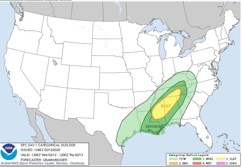 Severe weather outlook for Wednesday through 7 AM Thursday from the Storm Prediction Center
*** TOTAL RAINFALL that I am expecting THIS WEEK: 3 to 4" of rain with isolated 5" + amounts when you add up Monday's rain, plus what we get Today, plus Wednesday, plus Thursday of this week. *** LAST WEEK, Knoxville received 5.63" of rain from Tuesday to Thursday. McGhee Tyson Airport so far this week. Yesterday (Monday): 0.92" Today, as of 11 AM: 1.24" So Far... 2.16" That means in one week or 7 days, Knoxville has received, as of 11 AM today: over 7.79" of rain and 1.0" of snow. ***TURN AROUND, DON'T DROWN ! *** 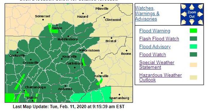 From NWS-Morristown East Tennessee is no longer under a FLOOD WATCH (that has been canceled by NWS-Morristown), but rather we are now under a FLASH FLOOD WATCH. So what's the difference? A FLOOD WATCH means "Be Prepared." A Flood Watch is issued when conditions are favorable for a specific hazardous weather event to occur. A Flood Watch is issued when conditions are favorable for flooding. It does not mean flooding will occur, but it is possible. A FLASH FLOOD WATCH means that conditions may develop that lead to flash flooding. Flash flooding is a very dangerous situation. A flash flood is a sudden violent flood that can take from minutes to hours to develop. If you come to a closed or flooded road...turn around! Don`t drown! Today: Cloudy, periods of rain, 80% chance, heaviest rain should fall in the morning, highs in the upper 50s to near 60 Tonight: Gray skies, spotty rain showers, 20% chance, lows in the lower to mid 40s Wednesday: Mainly gray, few showers, 40% chance, highs in the lower 60s Wednesday night: Rain showers increase, 60% chance, lows in the lower to mid 50s Thursday: Periods of rain, mostly in the morning, 80% chance, early highs in the lower 60s and FALLING Thursday night: Clouds decrease, turning sharply colder, lows in the mid 20s. Friday / Valentine's Day: Mostly sunny, cold, highs in the lower to mid 40s For the latest 7 Day Forecast for your town or location, check out the Captain Accurate Weather App. I also have a BRAND NEW horizontal 7 Day Forecast for Knoxville and a BRAND NEW Video, posted daily, on the home page of CaptainAccurate.com and on the Captain Accurate Weather App. Check it out here. When your forecast matters #CaptAccurateWx P.S. If you find these independent forecasts and posts helpful, please consider supporting me by downloading my NEW Captain Accurate Weather App. It's FREE. Just search: Captain Accurate at the App Store and Google Play. It comes with 5 FREE App Tutorials, so you can quickly learn all the wonderful things it can do.
Captain Accurate is expecting 3 to 4" of rain with isolated 5" + amounts from Today through Thursday of this week. More FLOODING will be possible. Some of the HEAVIEST RAIN should arrive later tonight into early Tuesday morning. 1 AM to 8 AM Tuesday is a time to watch. Turn Around, Don't Drown! For the latest 7 Day Forecast for your town or location, check out the Captain Accurate Weather App. I also have a BRAND NEW horizontal 7 Day Forecast for Knoxville and a BRAND NEW Video, posted daily, on the home page of CaptainAccurate.com and on the Captain Accurate Weather App. Check it out here. When your forecast matters #CaptAccurateWx P.S. If you find these independent forecasts and posts helpful, please consider supporting me by downloading my NEW Captain Accurate Weather App. It's FREE. Just search: Captain Accurate at the App Store and Google Play. It comes with 5 FREE App Tutorials, so you can quickly learn all the wonderful things it can do.
A FLOOD WATCH for parts of East Tennessee is in effect this morning and runs through Tuesday evening. 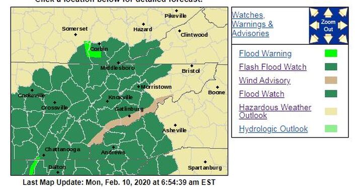 From NWS-Morristown Captain Accurate also takes another look at WINTER. See my latest video here. Today: Cloudy with periods of rain, an 80% chance, highs in the lower to mid 50s Tonight: More clouds, more rain, downpours, 80% chance, lows in the upper 40s ***TURN AROUND, DON'T DROWN ! *** Tuesday: Cloudy, periods of rain, 80% chance, heaviest rain should fall in the morning, highs in the lower 60s Tuesday night: Scattered rain showers, 40% chance, lows in the lower to mid 40s Wednesday: Mainly gray, few showers, 40% chance, highs in the lower 60s Wednesday night: Scattered rain showers, 60% chance, lows in the lower 50s Thursday: Periods of rain, 80% chance, early highs in the lower 60s and FALLING *** I am expecting 3 to 4" of rain with isolated 5" + amounts from Monday through Thursday of this week. *** For the latest 7 Day Forecast for your town or location, check out the Captain Accurate Weather App. I also have a BRAND NEW horizontal 7 Day Forecast for Knoxville and a BRAND NEW Video, posted daily, on the home page of CaptainAccurate.com and on the Captain Accurate Weather App. Check it out here. When your forecast matters #CaptAccurateWx P.S. If you find these independent forecasts and posts helpful, please consider supporting me by downloading my NEW Captain Accurate Weather App. It's FREE. Just search: Captain Accurate at the App Store and Google Play. It comes with 5 FREE App Tutorials, so you can quickly learn all the wonderful things it can do.
“Easy Snow, Easy Go.” Knoxville received its first 1.0 inch of snow today, officially this winter at McGhee Tyson Airport. Knoxville got 2.0 inches of snow last autumn. Knoxville’s morning low today was 27° and had a high of 40° today. Here's an easy, interactive way to determine how much snow fell today, thanks to my friends at the National Weather Service in Morristown. Click this link and simply move your cursor over each purple dot. BTW, 3 to 4" of RAIN with isolated 5" amounts will be possible next week. At least Sunday, tomorrow, should be mostly sunny and pleasant, after some early morning fog. For the latest 7 Day Forecast for your town or location, check out the Captain Accurate Weather App. I also have a BRAND NEW horizontal 7 Day Forecast for Knoxville and a BRAND NEW Video, posted daily, on the home page of CaptainAccurate.com and on the Captain Accurate Weather App. Check it out here. When your forecast matters #CaptAccurateWx P.S. If you find these independent forecasts and posts helpful, please consider supporting me by downloading my NEW Captain Accurate Weather App. It's FREE. Just search: Captain Accurate at the App Store and Google Play. It comes with 5 FREE App Tutorials, so you can quickly learn all the wonderful things it can do.
Here's my latest SNOW map for Saturday. Wet snow could still mix in with some rain. Best time to watch? 10 AM to 2 PM Saturday. As always, drive carefully. *** Published at 10:45 PM Friday night. ---signed Captain Accurate 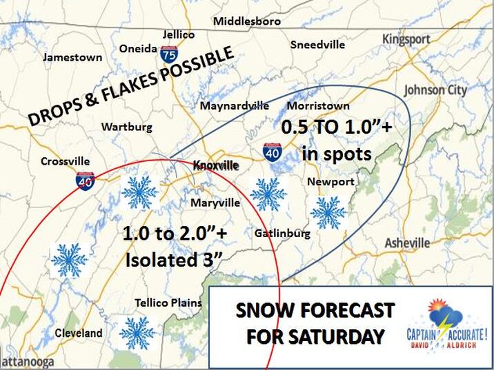 My latest SNOW map for Saturday, 2/8/2020
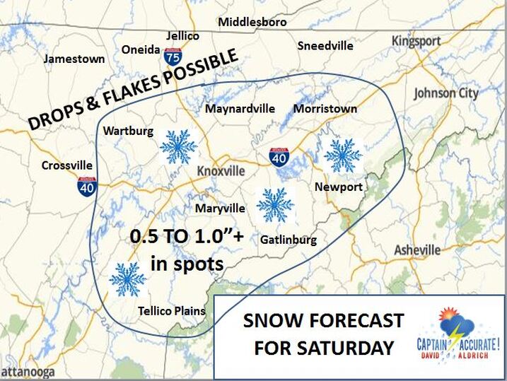 My Snow Forecast for Saturday...initially it comes up from the South Tonight: Flurries & snow showers fade. Mix of clouds and stars, colder, beware of black ice, lows around 28° Saturday: Mostly cloudy, rain and wet snow showers return, 40% chance. Highs in the lower to mid 40s. Some accumulation will be possible. See my Snow map above. 0.5 to 1.0"+ of snow would be possible in spots, not area-wide. If it mixes more with rain, than those numbers would be much less. Best time frame to watch? 10 AM to 2 PM Saturday. Saturday night: Becoming mostly clear and cold, fog late, patchy dense and freezing, lows in the mid to upper 20s Sunday: Early fog, mostly sunny, pleasant, highs in the mid 50s Sunday night: Increasing clouds, lows in the lower 40s Monday: Cloudy with periods of rain developing, an 80% chance, highs in the mid 50s Monday night: More clouds, more showers, 80% chance, lows in the upper 40s Tuesday: Cloudy, periods of rain, 80% chance, highs in the upper 50s If you combine Monday and Tuesday, the amount of rainfall that is projected to fall is around 1.50" + across East Tennessee, based on averages from today's model data. For the latest 7 Day Forecast for your town or location, check out the Captain Accurate Weather App. I also have a BRAND NEW horizontal 7 Day Forecast for Knoxville and a BRAND NEW Video, posted daily, on the home page of CaptainAccurate.com and on the Captain Accurate Weather App. Check it out here. When your forecast matters #CaptAccurateWx P.S. If you find these independent forecasts and posts helpful, please consider supporting me by downloading my NEW Captain Accurate Weather App. It's FREE. Just search: Captain Accurate at the App Store and Google Play. It comes with 5 FREE App Tutorials, so you can quickly learn all the wonderful things it can do.
 My Snow Forecast for Friday Updated 9:15 AM Friday Knoxville's high today of 44° came at 12:23 AM. Today: Flurries and wet snow showers possible, 60% chance. Mostly cloudy. Daytime temperatures steady in the mid 30s. See my Snow Map above. Tonight: Mix of clouds and stars, colder, beware of black ice, lows around 28° Saturday: Mostly cloudy, spotty rain and snow showers, 20% chance, mostly in the afternoon and evening. Wet snow possible in the higher elevations of the Plateau, SE KY and Smokies. Highs in the mid 40s. Saturday night: Partly cloudy and cold, lows in the upper 20s Sunday: Bright sunshine, pleasant, highs in the mid to upper 50s Sunday night: Increasing clouds, lows in the mid 40s Monday: Cloudy with 60% chance of rain showers, highs in the upper 50s For the latest 7 Day Forecast for your town or location, check out the Captain Accurate Weather App. I also have a BRAND NEW horizontal 7 Day Forecast for Knoxville and a BRAND NEW Video, posted daily, on the home page of CaptainAccurate.com and on the Captain Accurate Weather App. Check it out here. When your forecast matters #CaptAccurateWx P.S. If you find these independent forecasts and posts helpful, please consider supporting me by downloading my NEW Captain Accurate Weather App. It's FREE. Just search: Captain Accurate at the App Store and Google Play. It comes with 5 FREE App Tutorials, so you can quickly learn all the wonderful things it can do.
New RAINFALL Data coming in for Thursday for Knoxville and East Tennessee
Model A...5.20" Model B...4.12" Model C...1.27" 3 Model Average: 3.53" of potential rain still to come with locally higher amounts. Bottom line? Please be careful. Turn Around, Don't Drown! Beware of mud slides. Be extra careful driving at night. And when you see rising waters, seek higher ground immediately. What's going on? It's a SLOW-moving cold front, so rain is likely to parade over the same areas time and time again between now and Thursday evening. Again, numbers above refer to model data, which does NOT always handle slow-moving or stalled systems well. Two slides below from my friends at the National Weather Service in Morristown: 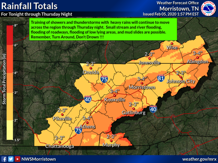 From NWS-Morristown 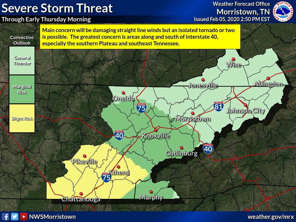 From NWS-Morristown In addition to what you already have received...add another 2 to 4"+ of rain for tonight & Thursday with isolated 5" + amounts. What's going on? It's a SLOW-moving cold front, so rain is likely to parade over the same areas time and time again between now and Thursday evening. Numbers below refer to model data, which does NOT always handle slow-moving or stalled systems well. Future RAINFALL AVERAGES for Thursday Model A...1.95" Model B...1.73" Model C...4.42" 3 Model Average: 2.70"...with locally higher amounts Flash flooding, localized flooding and significant rises in creeks and streams will be possible over the next 24 to 36 hours. Turn Around, Don't Drown! Tonight: Cloudy, more rain, downpours, gusty, isolated thunder, 100% chance, lows in the upper 50s to around 60° TADD = "Turn Around, Don't Drown!" Thursday: Cloudy, soggy, occasional downpours, highs in the lower to mid 60s Friday: Morning flurries or snow showers possible. Some rain may mix in, too. Becoming partly sunny. Highs in the lower to mid 40s. *** Early indications bring the potential of 0.5 to 2.0" of snow for parts of the Plateau and Southeast Kentucky on Friday. Smokies would receive some of this, too, but mainly above 3,000 feet. Very little snow for the Valley, perhaps just flurries. Keep in mind, this would be snow showers, not a snow storm. Classic Horseshoe Effect. Stay tuned. *** Friday night: Clouds thicken, colder, lows around 30° Saturday: Cloudy, scattered rain showers, 40% chance, mostly in the afternoon and evening. Wet snow possible in the higher elevations of the Plateau, SE KY and Smokies. Highs in the lower to mid 40s. Saturday night: Mostly cloudy, some leftover rain and snow showers, lows around 30° Sunday: Early clouds to sunshine, dry, highs in the mid 50s For the latest 7 Day Forecast for your town or location, check out the Captain Accurate Weather App. I also have a BRAND NEW horizontal 7 Day Forecast for Knoxville and a BRAND NEW Video, posted daily, on the home page of CaptainAccurate.com and on the Captain Accurate Weather App. Check it out here. When your forecast matters #CaptAccurateWx P.S. If you find these independent forecasts and posts helpful, please consider supporting me by downloading my NEW Captain Accurate Weather App. It's FREE. Just search: Captain Accurate at the App Store and Google Play. It comes with 5 FREE App Tutorials, so you can quickly learn all the wonderful things it can do.
Updated 8:53 AM Wednesday Strong to severe storms today should stay well SOUTH and WEST of East Tennessee, although isolated storms will still be possible here. 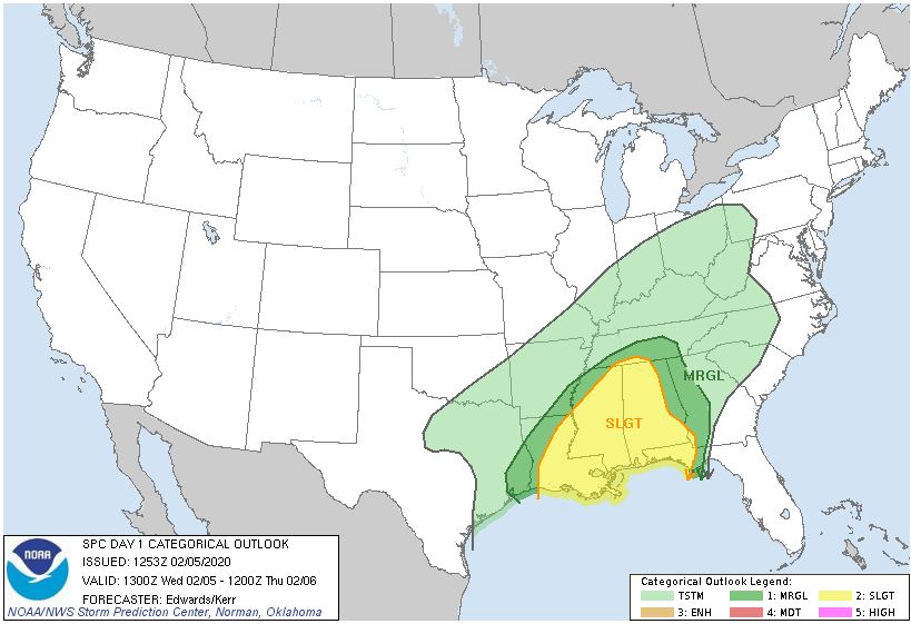 From the Storm Prediction Center in Norman, OK 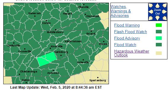 FLASH FLOOD WATCH from NWS-Morristown ...FLASH FLOOD WATCH IN EFFECT FROM WEDNESDAY EVENING THROUGH LATE THURSDAY NIGHT... for the counties shaded in GREEN, for 2 to 4" + of rain, with isolated higher amounts, according to the National Weather Service in Morristown. What's going on? It's a SLOW-moving cold front, so rain is likely to parade over the same areas time and time again between now and Thursday evening. Numbers below refer to model data, which does not always handle slow-moving systems well. In addition to what you may have received... Future RAINFALL AVERAGES this week Wednesday...1.00" Thursday...2.05" TOTAL...3.05"...with locally higher amounts Localized flooding with rises in creeks and streams will be possible over the next 2 days. Turn Around, Don't Drown! Today: Cloudy, periods of rain, downpours, gusty winds around 30 to 35 mph, isolated thunder, 80% chance, highs in the mid to upper 60s. Tonight: Cloudy, more rain, downpours, gusty, isolated thunder, 100% chance, lows in the upper 50s TADD = "Turn Around, Don't Drown!" Thursday: Cloudy, soggy, occasional downpours, highs in the lower to mid 60s Friday: Morning flurries or snow showers possible. Some rain may mix in, too. Becoming partly sunny. Highs in the lower to mid 40s. *** Early indications bring the potential of 0.5 to 2.0" of snow for parts of the Plateau and Southeast Kentucky on Friday. Smokies would receive some of this, too, but mainly above 3,000 feet. Very little snow for the Valley, perhaps just flurries. Keep in mind, this would be snow showers, not a snow storm. Classic Horseshoe Effect. Stay tuned. *** Friday night: Increasing clouds, colder, lows around 30° Saturday: Cloudy, scattered rain showers, mostly in the afternoon and evening. Wet snow possible in the higher elevations of the Plateau, SE KY and Smokies. Highs in the lower to mid 40s. For the latest 7 Day Forecast for your town or location, check out the Captain Accurate Weather App. I also have a BRAND NEW horizontal 7 Day Forecast for Knoxville and a BRAND NEW Video, posted daily, on the home page of CaptainAccurate.com and on the Captain Accurate Weather App. Check it out here. When your forecast matters #CaptAccurateWx P.S. If you find these independent forecasts and posts helpful, please consider supporting me by downloading my NEW Captain Accurate Weather App. It's FREE. Just search: Captain Accurate at the App Store and Google Play. It comes with 5 FREE App Tutorials, so you can quickly learn all the wonderful things it can do.
Updated 8:44 AM Tuesday Future RAINFALL AVERAGES this week Today...0.42" Wednesday...0.59" Thursday...1.25" TOTAL...2.26"...with locally higher amounts Today: Cloudy, 80% chance for rain showers, highs around 60° Tonight: Very warm, rain on & off, 80% chance, milder lows in the mid 50s Wednesday: Cloudy, periods of rain, isolated thunder, 80% chance, highs in the mid to upper 60s Wednesday night: Cloudy, more rain, 100% chance, lows in the mid to upper 50s Thursday: Cloudy, soggy, occasional downpours, highs in the lower to mid 60s ***Footnote: I am expecting around two inches + of rain from Today through Thursday, spread out over 3 days.*** Friday: Morning flurries or snow showers possible. Some rain may mix in, too. Becoming partly cloudy. Highs in the lower to mid 40s. For the latest 7 Day Forecast for your town or location, check out the Captain Accurate Weather App. I also have a BRAND NEW horizontal 7 Day Forecast for Knoxville and a BRAND NEW Video, posted daily, on the home page of CaptainAccurate.com and on the Captain Accurate Weather App. Check it out here. When your forecast matters #CaptAccurateWx P.S. If you find these independent forecasts and posts helpful, please consider supporting me by downloading my NEW Captain Accurate Weather App. It's FREE. Just search: Captain Accurate at the App Store and Google Play. It comes with 5 FREE App Tutorials, so you can quickly learn all the wonderful things it can do.
SPRING FEVER ALERT ! Nashville hit 71° on Sunday, so expect a very warm Monday in East Tennessee. Tree pollen is rising. Allergy sufferers, take note. Overnight lows in the 50s this week will trigger that response. --- Captain Accurate Today: Mostly sunny & warm breeze, gusts around 25 mph, highs in the upper 60s to around 70° The record high is 72° (1986) Tonight: Increasing clouds, spots of rain by daybreak, very mild, lows in the lower 50s Tuesday: Cloudy, 80% chance for rain showers, highs around 60° Tuesday night: More rain showers, 80% chance, milder lows in the mid 50s Wednesday: Cloudy, periods of rain, 80% chance, highs in the mid 60s Wednesday night: Cloudy, more rain, 100% chance, lows in the mid to upper 50s Thursday: Cloudy, soggy, occasional downpours, 100% chance of rain, highs in the lower to mid 60s Footnote: I am expecting around two and a half inches + of rain from Tuesday through Thursday, spread out over 3 days. For the latest 7 Day Forecast for your town or location, check out the Captain Accurate Weather App. I also have a BRAND NEW horizontal 7 Day Forecast for Knoxville and a BRAND NEW Video, posted daily, on the home page of CaptainAccurate.com and on the Captain Accurate Weather App. Check it out here. When your forecast matters #CaptAccurateWx P.S. If you find these independent forecasts and posts helpful, please consider supporting me by downloading my NEW Captain Accurate Weather App. It's FREE. Just search: Captain Accurate at the App Store and Google Play. It comes with 5 FREE App Tutorials, so you can quickly learn all the wonderful things it can do.
Updated 11:45 AM Sunday Punxsutawney Phil did NOT see his shadow this morning for the 20th time since 1887. This result would suggest an early spring. But Phil is also believed to be accurate only 39% of the time. We'll see. :-) Groundhog Day / Super Bowl Sunday: Sunshiny skies, warm breeze, SW 5-15 mph, gusts 25 to 30 mph, highs in the upper 50s to near 60° Tonight: Mostly clear, mild, lows around 40° Monday: Mostly sunny & warm breeze, gusts to 25 mph, highs in the mid to upper 60s Monday night: Increasing clouds, very mild, lows near 50° Tuesday: Cloudy, 60% chance for rain showers, highs around 60° Tuesday night: More rain showers, 60% chance, milder lows in the mid 50s Wednesday: Cloudy, periods of rain, 80% chance, highs in the mid 60s For the latest 7 Day Forecast for your town or location, check out the Captain Accurate Weather App. I also have a BRAND NEW horizontal 7 Day Forecast for Knoxville and a BRAND NEW Video, posted daily, on the home page of CaptainAccurate.com and on the Captain Accurate Weather App. Check it out here. When your forecast matters #CaptAccurateWx P.S. If you find these independent forecasts and posts helpful, please consider supporting me by downloading my NEW Captain Accurate Weather App. It's FREE. Just search: Captain Accurate at the App Store and Google Play. It comes with 5 FREE App Tutorials, so you can quickly learn all the wonderful things it can do.
|
David AldrichCaptain Accurate Weather Archives
April 2024
Categories |


 RSS Feed