|
CAPTAIN ACCURATE'S WEATHER
BLOG |

|


|
Knoxville & the Valley Tonight, mostly clear, lower to mid 20s Thursday, becoming partly sunny, high in the lower to mid-40s Friday, partly sunny, high in the upper 40s to near 50 Saturday & Sunday, lower to mid-50s, bright sunshine both days with morning lows in the lower to mid-30s Garth Brooks Concert, Saturday, November 16th, at Neyland Stadium, 7 PM Starry skies Near 40° at 7 PM Around 35° by 11 PM Dress warmly. Winds: VRB 0-5 mph Because "The Thunder Rolls" - Garth Brooks #CaptAccurateWx 
0 Comments
Knoxville TIED a Record Low as we walked out the door at 11:44 PM Late Tuesday night. Last night ties the Record Low from 1987, when Ronald Reagan was President. Tuesday’s Almanac MAXIMUM 54° 12:16 AM MINIMUM 20°R 11:44 PM This is in addition to having “the Earliest Recorded Snowfall of 1.0” or Greater” ❄️ 1.7” since Knoxville records have been kept in 1871. Thank you, NWS-Morristown for keeping track. This morning’s record low of 17° (1911) was NOT achieved, but as Captain Accurate had said in LAST SATURDAY'S BLOG...“I’ll Be Close.” We made up for it, in many cases, with single-digit wind chills this morning. Knoxville...19°...wind chill...8° Oak Ridge...21°...wind chill...21° Crossville...13°...wind chill...1° Morristown...18°...wind chill...11° Sevierville Gatlinburg-Pigeon Forge Airport...18°...wind chill...18° Middlesboro, KY...15°...wind chill...15° 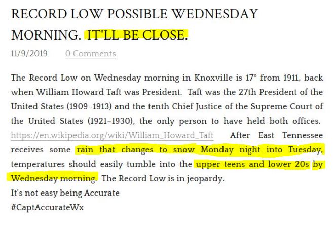 Today's high in Knoxville was 54° at 12:16 AM Today's low in Knoxville was 25° as of 5:53 PM, as of 6 PM. Of course, it's going to continue to get COLDER as we head through the night. If we get below 20° before midnight, we will break a record low of 20° from 1987. If you go to the Home page of CaptainAccurate.com...scroll down until you find "My Weather Toolbox," you'll find a Wind Chill Chart along with some other great tools for each and every weather season. Record low Wednesday morning: 17° (1911). Early Wednesday morning: Lows in Record Territory for Knoxville around 16°, wind speed around 3 to 7 mph, would yield a wind chill of 4° to 9° above. SINGLE DIGIT WIND CHILLS. Dress warmly for both you and your children. And be mindful of possible icy patches under foot. When your Forecast matters... #CaptAccurateWx 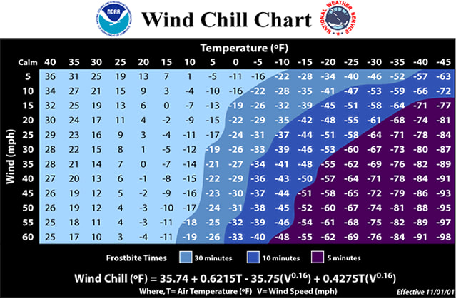 Well, it was the FIRST SNOW of the Season. The Fall Season. At 5:22 AM, the observer at the Airport had measured 0.3” of snow at McGhee Tyson. 1 hour & 38 minutes later... By 7:00 AM, the observer at the Airport had measured a total of 1.7” of snow. And the snow, by then, had already ended. That means for a brief time this morning, snow was falling at roughy 1" per hour, thus reducing visibility to 0.75 miles around 6:53 AM, based on the Airport observations. Captain Accurate was calling for the potential of 1 to 3” snow in the Valley. Last I checked, 1.7” falls between 1” to 3”. Sad that I have to point that out, as some only heard 3”. What I actually wrote in the blog was: "Most in the Valley will see 1 to 2" of snow fall with even less actually sticking on the pavement." Here's some more SNOWFALL TOTALS from NWS. BTW, Knoxville got 1.8" of snow on January 29th of this year, making today's snow the biggest snow in 9.5 months. So where do we go from here? Temperatures will continue to DROP. The Record low for Wednesday morning is 17° from 1911. The Record low in Knoxville for today, however, is 20° from 1987...back when Ronald Reagan was in the White House. I know what some of you may be thinking: "David, it's not that COLD today." Ahhh ! Not yet, but the 20° record low for today may be hit later tonight, after dark and before midnight. That would put 2 Record lows in play. Something to watch. Make sure you & your kids have sweaters, layers and a warm coat, tonight and Wednesday, especially. Track the FALLING temperatures in Knoxville here: Today, slow decrease in clouds, BITTER wind, falling temperatures Tonight, mostly clear and COLDER, low near 16°......Record low territory Wednesday, sunshiny and cold, highs in the lower to mid 40s AND STARTING NOW, WE BEGIN ANOTHER DRY SPELL. It''s not easy being Accurate #CaptAccurateWx 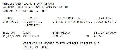 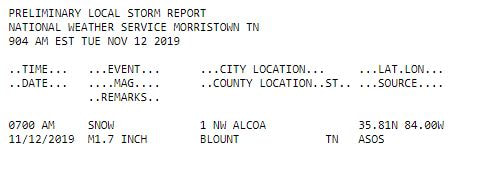 Here is my Final Forecast before the event starts tonight. I've made no big changes. RAIN STARTS: This evening RAIN ENDS Midnight to 2 AM Tuesday SNOW STARTS 2 AM to 4 AM Tuesday SNOW ENDS Around 8 AM Tuesday It starts out as RAIN, but will changeover in the wee hours of Tuesday morning. No surprise here. The rain will ultimately change over to plain snow, but some mixing of freezing rain and sleet may be observed in the middle, during that process, especially in the Plateau, around Crossville and Jamestown. Snow accumulation will be more noticeable on grassy surfaces, car roofs and on patio furniture, leaving less snow on the pavement, in most cases. Something I'm still watching... Mesoscale bands of snow, where areas are made different due to its elevation, temperature and topographic prominence, could easily form in the pre-dawn hours of Tuesday morning in East Tennessee. Just like fog can be locally dense in one part of a town and not so bad in another part of the SAME town. In other words, it would not surprise Captain Accurate if some of you receive more than 4 + inches of snow in a few Valley locations. So stay alert, and don't act surprised. However, that will NOT be the norm for most. Most in the Valley will see 1 to 2" of snow fall with even less actually sticking on the pavement. It will create, however, I'm sure, "snow envy" for those who LOVE snow, but feel they got cheated somehow in the process by Mother Nature. Psst ! You didn't. The practical solution on Tuesday morning? Hop in the car and take a short drive to the Smokies. :-) Enjoy...and above all, stay safe. So weather does not surprise you #CaptAccurateWx  Historical View of Knoxville Snow in November
Did you know Knoxville got 18.2" of snow in November of 1952? Sorry, folks, Captain Accurate didn't forecast it. I wasn't born yet until decades later. But according to records from the National Weather Service in Morristown, it's true. 16.0" of snow fell on November 21st, 1952 2.2" of snow fell on November 22nd, 1952 The one snow event equaled 18.2" of snow for Knoxville in November 1952. Shocking, isn't it? In fact, from 1883 to 2018, Knoxville averages 0.4" of snow in the month of November. Thank you, NWS-Morristown. Knoxville also got measurable snow, more than a Trace, as early as November 8th, back in the year of 1991...0.2". On the flip side of things... Many got so alarmed two months ago when Knoxville had the driest September on record in 2019. That's when only 0.03" of rain fell at the airport. And yet October 2019, historically the DRIEST month of the year, had nearly TWICE the normal amount of rainfall at 4.96"...as if to try and make up for lost time. And yet, no one seemed to think twice about that. But I did. I guess the moral of the story could be viewed like this: Nature's weather pendulum will swing in its own time. Analogy? How can a beach give us a high tide and a low tide all in the same day? The answer? It just does. It's cyclical. You can't live your life on where you "should be." Deep Thoughts by Captain Accurate #CaptAccurateWx Veterans Day is Monday, November 11th 11th Month 11th Day 11th Hour 11 AM Expect around 56° in Knoxville Afternoon high in the lower 60s, increasing clouds, showers develop late in the afternoon & into the evening Your sacrifice can never be repaid. Happy Veterans Day! #CaptAccurateWx  This STILL starts as RAIN, folks. The question is, how quickly will it changeover. I even said that yesterday. Well, here's the Valley timeline that I am expecting today: RAIN STARTS: 4 PM to 7 PM Monday RAIN ENDS Midnight to 2 AM Tuesday SNOW STARTS 2 AM to 4 AM Tuesday SNOW ENDS Around 8 AM Tuesday Something I'm watching... Mesoscale bands of snow, where areas are made different due to its elevation, temperature and topographic prominence, could easily form in the pre-dawn hours of Tuesday morning in East Tennessee. Just like fog can be locally dense in one part of a town and not so bad in another part of the SAME town. In other words, it would not surprise Captain Accurate if some of you receive more than 4 + inches of snow in a few Valley locations. So stay alert, and don't act surprised. However, that will NOT be the norm for most. Most in the Valley will see 1 to 2" of snow fall with even less actually sticking on the pavement. It will create, however, I'm sure, "snow envy" for those who LOVE snow, but feel they got cheated somehow in the process by Mother Nature. Psst ! You didn't. The practical solution on Tuesday morning? Hop in the car and take a short drive to the Smokies. :-) Enjoy...and above all, stay safe. So weather does not surprise you #CaptAccurateWx  The Record Low on Wednesday morning in Knoxville is 17° from 1911, back when William Howard Taft was President. Taft was the 27th President of the United States (1909–1913) and the tenth Chief Justice of the Supreme Court of the United States (1921–1930), the only person to have held both offices. https://en.wikipedia.org/wiki/William_Howard_Taft After East Tennessee receives some rain that changes to snow Monday night into Tuesday, temperatures should easily tumble into the upper teens and lower 20s by Wednesday morning. The Record Low is in jeopardy. It's not easy being Accurate #CaptAccurateWx 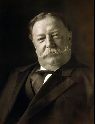 Be prepared to be "Horseshoed" late Monday night into Tuesday morning.
And if you get a "Ringer," according to the game of Horseshoes, that's worth 3 points: Plateau, Valley & Smokies, the least snowy will be the Valley. This starts as RAIN, folks. The question is... "how quickly will it changeover?" The answer depends on your elevation. NAM model today turns RAIN to SNOW in Knoxville & the Valley around 2 AM Tuesday GFS model today turns RAIN to SNOW in Knoxville & the Valley around 3 AM Tuesday In classic model style, 2.5 to 3 days away from the start of the event, there are snowfall accumulation differences. NAM model brings Knoxville & the Valley 0.10" of rain, then flurries GFS model brings Knoxville & the Valley 0.25" of rain, then snow falls, about 1 to 2" worth, but significantly less actually sticks. Stay tuned. The Plateau, Southeast KY, the Tri-Cities and the Smokies could easily pick up 0.5 to 3" of snow or more in spots...due to higher elevation...and colder air. But as I wrote yesterday... "BOTTOM LINE? This data will change again and again and again and again until the event. So, stay tuned." Tonight, mostly clear and really COLD...mid to upper 20s !
The LAST TIME Knoxville was in the 20s in the morning was March 7th, 8 months ago ! Normal Low for this time of year: 41° The RECORD LOW is 24° from 1995...it's SAFE. No broken record expected at McGhee Tyson Airport. Saturday, mostly sunny, lower to mid-50s (Go Vols! See my UPDATED Kentucky forecast for the evening game on a previous BLOG post below.) Sunday, more sunshine, around 60° Meanwhile...let me paint you a picture. Close your eyes. Imagine the future. It's RAINING outside. Even steady at times. No big deal. But a little bit later, you look, and it's now RAINING & SNOWING at the same time (Oh my!), with some icy pellets (sleet) mixed in as well. Funny thing, you notice, if you live in Knoxville & the Valley, nothing is sticking to the pavement. But then, before you know it, it all changes over to SNOW...for like 5 minutes or so. Then, done. From this distance, 3.5 to 4 days away, here's my recap, 0.25" of RAIN, followed by 0.10" of BOTH RAIN & SNOW falling at the SAME time followed by 0.02" of FLURRIES (pesky flakes) Done. The End. Any questions? This represents Monday night, November 11th and the morning of Tuesday, November 12th in the eyes of Captain Accurate. BOTTOM LINE? This data will change again and again and again and again until the event. So, stay tuned. From this distance, this is a small event for most and a minor accumulation event for the Smokies, Plateau and parts of Kentucky So weather does not surprise you #CaptAccurateWx This morning's low in Knoxville was 45°. Mid-50s this afternoon have been common. Rain began falling at 10:17 AM, according airport records. Captain Accurate said expect rain to start falling "Late Morning." Thankfully, it did not affect the morning drive to work or school. Meanwhile... Rainfall amounts, as of 2 PM at McGhee Tyson Airport, were at 0.30" so far. It will be drippy tonight, especially for the early evening...then clouds will decrease...and sunshiny skies will return on Friday, but colder. Falling into the lower 30s tonight. Mid-40s for highs on Friday. Bright sunshine continues Saturday (lower to mid-50s) and Sunday (around 60). Looking ahead to next Monday night into Tuesday, we should be receiving our first Autumn snowfall of the season...with some rain and ice to start. Keep in mind, we will be "horseshoed." If you have watched my Winter Weather Outlook on CaptainAccurate.com, then that reference of a "Horseshoe Effect" should be understood. From this distance, it will be a small event where it's the story of the "snows" and "snow nots" in terms of accumulation. Stay tuned. It's a fluid situation that is still 4.5 to 5 days away. Translation? Expect lots of changes.  Today's high and low in Knoxville was 68° and 40°. Tonight, mid-40s, partly cloudy with some patchy fog late Thursday, plenty of clouds, SHOWERS, highs in the mid to upper 50s With rain showers arriving LATE MORNING around 11 AM from the West, new data for rainfall amounts is as follows: Model A: 0.70" Model B: 0.60" Model C: 0.81" 3 Model average: 0.703" #NWSMorristown #CaptAccurateWx  This morning's low in Knoxville was 40°.
With sunshiny skies today, look for a high in the mid-60s Tonight, mid-40s, partly cloudy with some patchy fog late Thursday, rain arrives LATE MORNING from the West and continues through the afternoon and evening, 80% chance, highs in the mid-50s Expect a little more than a HALF inch of rain on average #CaptAccurateWx Tennessee Volunteers (4-5) @ Kentucky Wildcats (4-4) Saturday, November 9th Battle for the Barrel Kroger Field Lexington, KY Daytime highs in the mid to upper 40s Plenty of sun 5:31 PM Sunset Televised on the SEC Network 7:30 PM Kickoff Partly cloudy Lower to mid-40s for kickoff and for the balance of the game SW winds 5-15 mph #GoVols #GBO #CaptAccurateWx Credit: Ron Mulig for the cool artwork Welcome to CaptainAccurate.com I'm so excited you're here. Everyone is welcome. I will be posting important weather information all winter long for the Knoxville area and East Tennessee here on this blog. Keep it bookmarked, as it will be very useful in the days and months ahead. It's a New day #CaptAccurateWx   Welcome ! Who's excited ? Well, you've come to the right place. My video will be here exclusively on CaptainAccurate.com very soon, so please check back often. It is here that I will be outlining in detail what this winter will look like in East Tennessee so that you & your family can be prepared. I will also discuss upcoming temperatures changes and the reason why as well as snowfall amounts, so stay tuned !!!
|
David AldrichCaptain Accurate Weather Archives
April 2024
Categories |
 RSS Feed