|
CAPTAIN ACCURATE'S WEATHER
BLOG |

|


|
Get READY! It's the LAST week of Fall. Winter officially starts on Saturday, December 21st at 11:19 PM EST, astronomically speaking. Tonight: Increasing clouds, spots of rain possible, lows in the mid-40s and RISING. Monday: Mostly cloudy, some hazy sun, GUSTY winds 35-40 mph from the Southwest, but even higher on hilltops with spotty rain possible, 20% chance. Highs in the upper 60s. Record high: 71° (1929) Monday night: Rainy downpours with BIG puddles, isolated thunderstorms, 100% chance of rain, warm, generally staying in the 60s until 4 AM Tuesday, then FALLING. Tuesday: Rainy, especially in the morning, 60% chance, otherwise, mostly cloudy, FALLING through the 50s and ending the day around 40°, making it truly an "UPSIDE Down" day, thanks to the passage of a cold front. If you find these forecasts helpful, please download my FREE Captain Accurate Weather App. Get weather alerts in an instant. Available now at the App Store and Google Play. Just search: Captain Accurate It's not easy being Accurate #CaptAccurateWx. Storm Prediction Center link: https://www.spc.noaa.gov/products/outlook/day2otlk.html 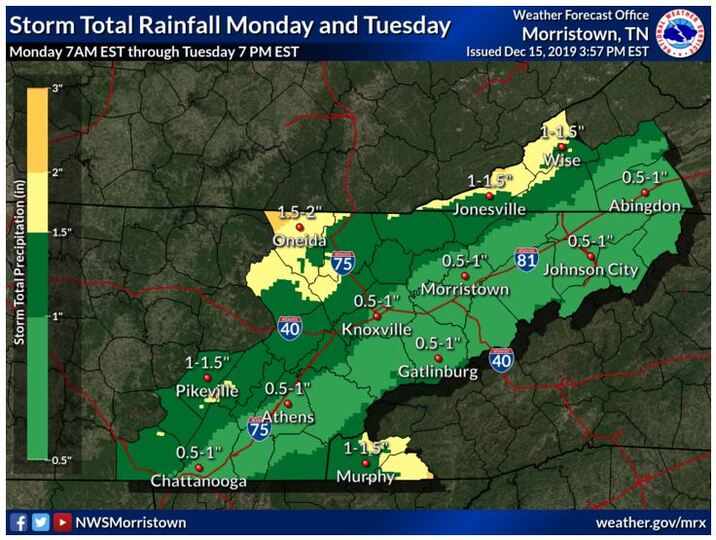 Severe Storms Expected Monday and Monday Night in Parts of Louisiana, Mississippi & Alabama
0 Comments
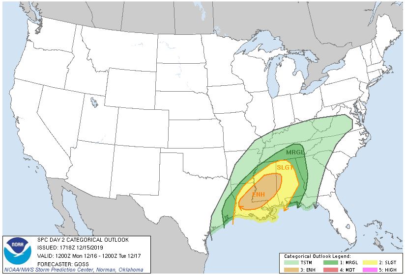 When a warning, watch or advisory is issued by the National Weather Service, how soon would you want to hear about it? The answer? Right away! Yet ANOTHER reason why having the Captain Accurate Weather App on your smartphone is key, especially this Monday. For example, you may have family in Mississippi, Louisiana or Alabama and may want to monitor their storms. Here is the Convective Outlook, as issued by the Storm Prediction Center, for Monday and Monday night. See map above. It puts the center of the severe storms in YELLOW (Slight Risk) over Mississippi, Louisiana and Alabama, where some tornadoes may occur. East Tennessee is under a "general thunderstorm risk" for Monday and Monday night, but of course, that could change, so stay tuned. There could be some localized flooding here in East Tennessee with strong gusty winds, especially for the Smokies by Monday evening. The Storm Prediction Center (SPC), based out of Norman, Oklahoma, covers the entire country and will use multiple labels and colors to describe their Outlooks. A good rule of thumb: MARGINAL risk (dark green) = Isolated severe storms SLIGHT risk (yellow) = Scattered severe storms ENHANCED risk (orange) = Numerous severe storms https://www.spc.noaa.gov/products/outlook/day3otlk.html Day 3 Convective Outlook CORR 1 NWS Storm Prediction Center Norman OK 0352 AM CST Sat Dec 14 2019 Valid 161200Z - 171200Z ...THERE IS A SLIGHT RISK OF SEVERE THUNDERSTORMS ACROSS FAR SOUTHEAST AR...EASTERN TX...MUCH OF LA...MS AND AL... CORRECTED FOR STATE ID TYPO ...SUMMARY... Isolated to scattered severe storms are expected Monday into Monday night from far eastern Texas into the lower Mississippi Valley and much of Mississippi and Alabama. Damaging wind gusts, a few tornadoes and isolated hail are all possible. ...Lower MS Valley into the Deep South Vicinity... Forecast guidance continues to trend deeper with the eastward-ejecting mid/upper trough moving across the Plains to the central U.S. on Monday. As a result, a weak surface low over AR during the morning is forecast to track more east/northeast into northern MS then into TN/KY. This will keep the warm sector confined further south across the lower MS Valley vicinity into the Gulf coast states. 60s F surface dewpoints will overspread much of the Gulf coast states ahead of an eastward-advancing cold front. Vertical shear continues to be impressive and supportive of supercells. Furthermore, latest forecast soundings from various guidance show some improvement in low level hodographs and convergence ahead of the front. This could act to increase tornado potential across parts of LA/MS/AL into the evening hours. However, deep layer southwesterly flow will generally be parallel to the surface front. As a result, a messy storm mode/evolution is expected with a mix of line segments/clusters and perhaps a few semi-discrete cells. MLCAPE will remain modest, around 500-750 J/kg, limited in part by cloud cover/weaker insolation. However, some areas that experience pockets of stronger heating could destabilize further. Midlevel lapse rates will be moderate, around 6.5-7.0 C/km and could result in some hail in more discrete modes. Otherwise, strong wind gusts and a few tornadoes (either from semi-discrete cells or via mesovortices in line segments) are expected. South and east extent of the Slight risk area remains somewhat in question given concerns over forcing, somewhat weaker shear and storms developing/moving into the area after peak heating. Therefore, expect some changes on the periphery of the Slight risk area in coming outlooks as details hopefully become clearer. ..Leitman.. 12/14/2019 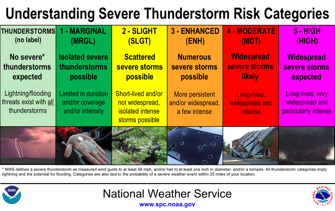  Tonight: Rainy, foggy, few downpours, 80% chance, lows in lower 40s. Normal low for this time of year: 32° Saturday: Gray skies, fog, showers, mostly in the early morning, 60% chance, highs in the upper 40s to near 50° Normal high for this time of year: 50° Saturday night: Mostly cloudy, spotty rain possible, lows in the upper 30s Sunday: Clouds with hazy sun developing, high in the lower 50s. So weather does not surprise you #CaptAccurateWx 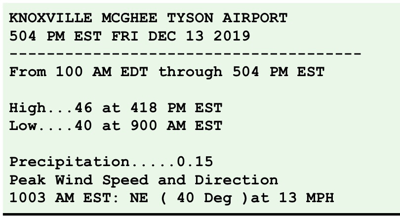 Tonight: More clouds, rain showers develop, 40% chance, lows in mid to upper 30s. *** A touch of FREEZING RAIN is possible tonight in Northeast Tennessee. Travelers, be advised. *** Normal low for this time of year: 32° Friday: Grab the umbrella. Gray skies, periods of rain, increasing to 80% chance, highs in the upper 40s Normal high for this time of year: 50° Friday night: More rain, 100% chance, few downpours, lows in the lower 40s Saturday: Mostly cloudy, scattered rain showers, 60% chance, high in the around 50°. What to Expect in terms of RAIN over the NEXT 2 Days: almost 1 inch. Model A...0.94" Model B...0.70" Model C...1.08" 3 Model Average: 0.906" Because Accurate forecasts don't grow on trees #CaptAccurateWx Tonight: Mostly clear and cold, lows in mid to upper 20s. Normal low for this time of year: 32° Thursday: Keep your sunglasses close. Mostly sunny, milder, highs in the lower 50s Normal high for this time of year: 50° Thursday night: More clouds, spotty rain develops, 20% chance, lows in the mid to upper-30s Friday: Gray skies with rain showers, 60% chance, but even MORE RAIN arrives Friday night with downpours, afternoon high in the upper 40s. Because Accurate forecasts don't grow on trees #CaptAccurateWx Here are the Knoxville Snows that occurred during the FALL Season. Keep in mind, it is not even winter yet. Winter officially starts on Saturday, December 21st at 11:19 PM EST, astronomically speaking. It's not easy being Accurate #CaptAccurateWx. 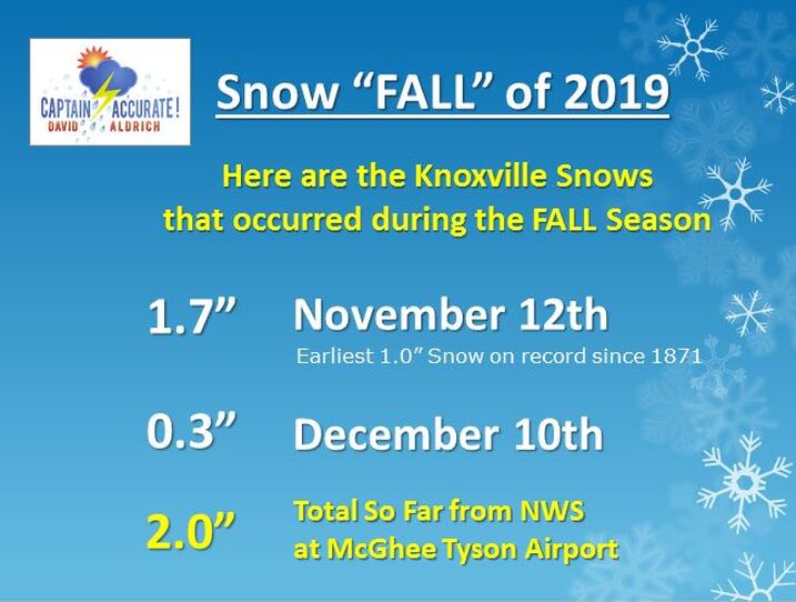 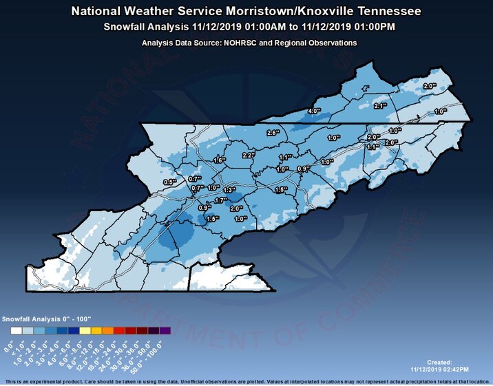 LAST MONTH'S SNOW...NOVEMBER 12, 2019 Here's what I expect in terms of snowfall, mostly on grassy surfaces, by 2 AM Wednesday. See map below. Take the higher number of my snowfall "range," if you live on a hill or on a higher elevation. Tonight: Wet snow showers, 80% chance, trace to as much as 2" on hilltops in the Valley, turning colder, lows in mid to upper 20s. Normal low for this time of year: 32° Wednesday: Grab the sunglasses. Sunshiny, bright & chilly, highs in the mid 40s. Normal high for this time of year: 51° Wednesday night: Mostly clear, lows in the upper-20s. Thursday: Mostly sunny, high in the lower 50s. So weather does not surprise you #CaptAccurateWx  Here's what I expect in terms of snowfall, mostly on grassy surfaces, by 2 AM Wednesday. See map below. Take the higher number of my snowfall "range," if you live on a hill or on a higher elevation. I believe the storm timeline, (the second picture below), is still on target for the Valley...the changeover to winter weather will occur much sooner in the day Tuesday for the Plateau and Southeast Kentucky. Travelers, be advised. If you find these forecasts helpful, then be sure to download my FREE Captain Accurate Weather App. The Data feature called "Future Radar (24-hours)" on the Captain Accurate Weather App works really well with weather events like this. Check it out. Just search: Captain Accurate at the App Store and on Google Play. It's FREE. Merry Christmas, East Tennessee. It's my gift to you! Thank you! The value of a forecast is not just what you say, but when you say it. #CaptAccurateWx 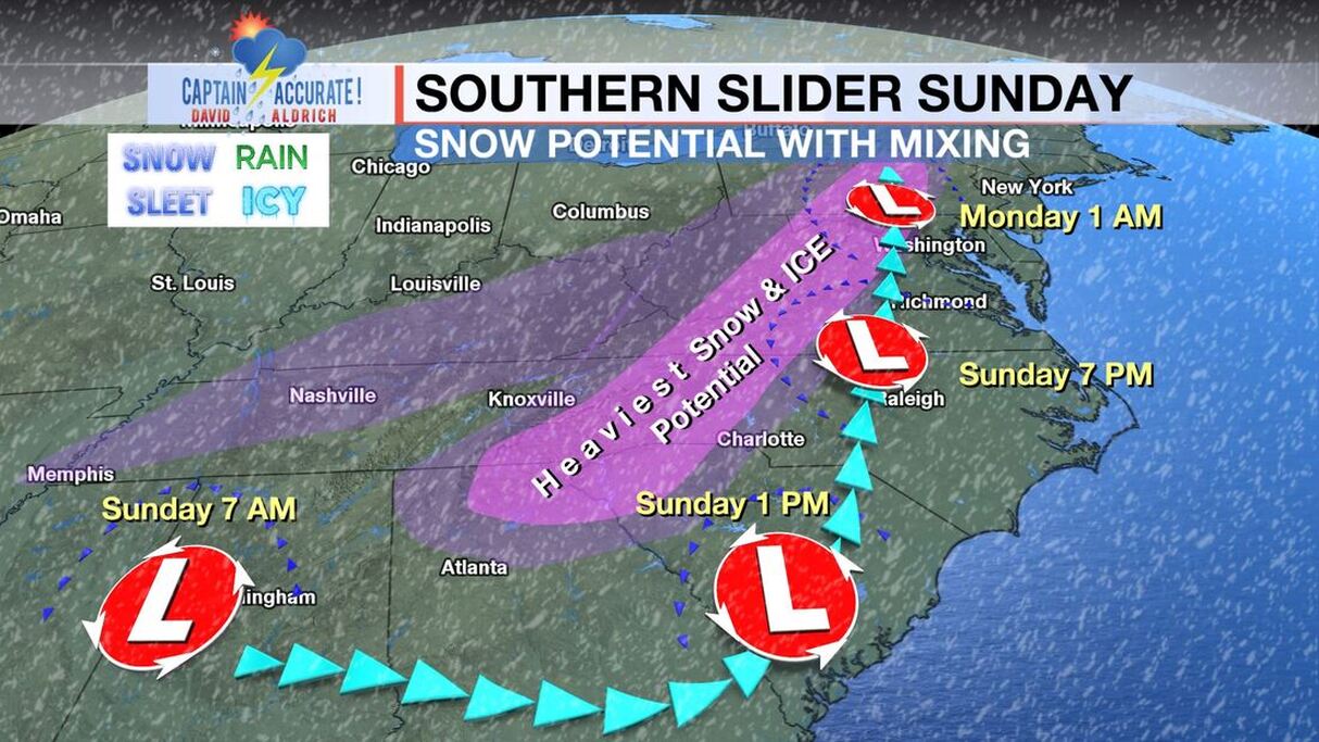 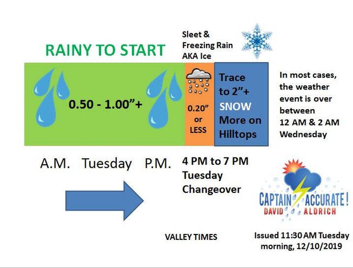 Sunday's high and low at McGhee Tyson Airport was 60° and 34°. Tonight: Clouds thicken, mild, spotty rain possible, 20% chance, lows in mid to upper 40s. Normal low for this time of year: 33° Monday: Plenty of clouds, spotty rain, 20% chance, breezy, especially in the afternoon, SW 10-20 + mph, highs in the mid 60s Normal high for this time of year: 51° Record high for Monday: 72° 1978 Monday night: Cloudy with more rain, especially late, 80% chance, lows in the mid-50s Tuesday: Cloudy with periods of rain, 0.50 to 0.75" + expected, 80% chance of rain, Morning sunrise high around 60° and falling into the 40s later in the afternoon. Tuesday night: Rainy night changes over to an icy mix. By 8 PM to 11 PM Tuesday, a changeover is expected. Ends with some snow or flurries. Trace to 2" + possible, mostly on grassy surfaces. More on Hilltops. Weather event should end between 3 AM and 5 AM Wednesday. If you follow my picture from left to right, you quickly get the sense that this weather event is two-thirds RAIN, followed by a little bit of ICE and ends as SNOW. Think about it: 15 hours of rain (off & on), 4 to 5 hours of SNOW, with some transition time in the middle. What finally does stick, in terms of SNOW, will find a home on grassy surfaces, cold car roof tops, and patio furniture. Hope this helps you plan. If you find these forecasts helpful, then be sure to download my FREE Captain Accurate Weather App. Search: Captain Accurate at the App Store and on Google Play. Thank you! It's not easy being Accurate #CaptAccurateWx 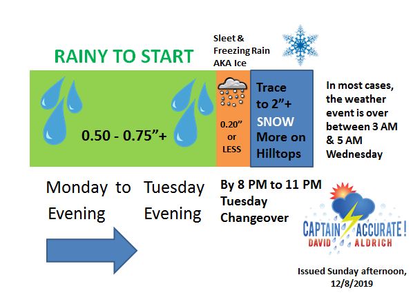 If you follow my picture from left to right, you quickly get the sense that this weather event is two-thirds RAIN, followed by a little bit of ICE and ends as SNOW. Think about it: 15 hours of rain (off & on), 4 to 5 hours of SNOW, with some transition time in the middle. What finally does stick, in terms of SNOW, will find a home on grassy surfaces, cold car roof tops, and patio furniture. Hope this helps you plan. ---signed Captain Accurate  Tonight: Mostly clear, lows in mid to upper 30s. Sunday: Hazy sun, few clouds, highs in the upper 50s, Monday Mostly cloudy, spotty rain, 20% chance, breezy, SW winds 10-20+ mph, highs in the lower to mid-60s More rain arrives on Tuesday with morning highs near 60° and FALLING. So weather does not surprise you #CaptAccurateWx 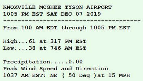 From NWS-Morristown I love serving the people of East Tennessee. So what I’m about to say, I say out of love. And for some of you, tough love. A teachable moment. Regarding the SNOW next week… My answer: we’ll see. By mid next week, if you live in Knoxville and the Valley, the horseshoe effect comes to mind. Would NOT surprise me if we got A WHOLE LOT of RAIN, followed by a little bit of ICE, and ends with a touch of SNOW. In the end, no big deal. Sadly, it’s the sign of the times. Every winter, a well-intended blogger, a weather enthusiast or weather outlet, will put out a piece of red meat. It’s not wars and rumors of wars, it’s snowflakes and rumors of snowflakes. They’ll dangle the idea of SNOW, regardless whether or not it’s based in fact...almost like click-bait. Usually the hype starts 1 to 2 weeks out. I call it “wish-casting,” not forecasting. And usually has origins on the run of one computer model. Fortunately, for you, this is not my first rodeo. “I heard this…” “Oh yeah, well, I heard we’re getting this…” And so it grows on social media. Instead they leave it to me, and others like me in the meteorological field, to clean up the mess. If the emotional roller coaster of thinking you’re gonna get blasted with lots of snow continues to let you down, then perhaps you shouldn’t listen to them as a weather source in the first place. Just saying. The pressure to produce the hyped weather event is on the source you heard it from. I assure you, I’m not asleep at the weather wheel. They call me Captain Accurate, not Captain Trendy. Calling it the way I see it, David Friday was full of clouds with spotty rain. McGhee Tyson Airport and Oak Ridge both received a TRACE of rain. Was expecting highs on Friday into the lower to mid-50s. Knoxville hit 52°, while Oak Ridge hit 54° for an afternoon high. Tonight: Clouds continue, spots of rain possible, lows near 40. Normal low for this time of year: 33° Saturday: Clouds to some hazy sun, highs in the mid to upper-50s. Normal high for this time of year: 52° Saturday night: More clouds, lows in upper 30s. Sunday: Hazy sun & clouds, highs in the mid 50s So weather does not surprise you #CaptAccurateWx 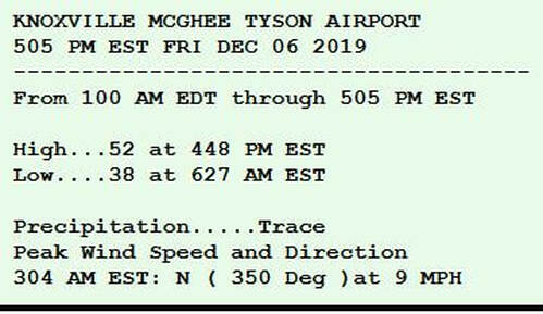 From NWS-Morristown Knoxville had bright sunshine on Thursday with a high of 58° and a morning low of 33°. Tonight: Mostly clear evening, increasing clouds late, lows in the upper 30s. Normal low for this time of year: 33° Friday: Mainly gray, spotty rain possible, 20% chance, highs in the lower to mid-50s. Normal high for this time of year: 52° Friday night: Mostly cloudy, lows upper 30s. Saturday: Early clouds to hazy sun, highs in the mid to upper 50s So weather does not surprise you #CaptAccurateWx 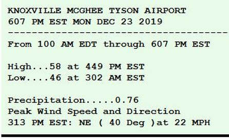 From NWS-Morristown Wednesday's morning low and afternoon high were 32° / 55°. Peak wind gust Wednesday was 27 mph. Tonight: Mostly clear, stays cold, touch of fog possible, lows in the lower to mid-30s. Normal low for this time of year: 34° Thursday: Mostly sunny, highs in mid-50s. Normal high for this time of year: 53° Thursday night: Increasing clouds, lows near 40°. Friday: Mostly cloudy, light rain showers possible, 40% chance, highs in the mid-50s So weather does not surprise you #CaptAccurateWx  From NWS-Morristown Tonight: Partly to mostly cloudy, remaining cold, lows in the lower 30s. Normal low for this time of year: 34° Wednesday: Bright sunshine developing, warm breeze, SW 5-15 mph with higher gusts, highs in the lower to mid-50s. Normal high for this time of year: 53° Wednesday night: Mostly clear, lows in the lower to mid-30s. Thursday: Mostly sunny, milder, highs in the mid-50s So weather does not surprise you #CaptAccurateWx 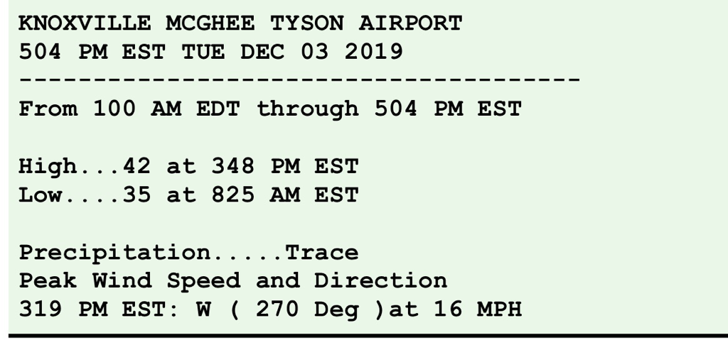 Tonight: Gray skies, stray flakes, winds diminish, cold, lows around 30°. Normal low for this time of year: 34° Tuesday: Mostly cloudy with some hazy sun developing, highs in the lower to mid-40s. Normal high for this time of year: 53° Tuesday night: Partly to mostly cloudy, lows in the lower 30s. Wednesday: Bright sunshine developing, highs in the lower to mid-50s BTW: The month of November for Knoxville finished -3.5° BELOW normal. McGhee Tyson Airport received 6.11" of rain and melted snow. That's 2.10" ABOVE normal for precipitation for the month. Highest temperature in November 2019: 68° on the 27th Lowest temperature in November 2019: 19° on the 13th On November 12th, 2019, Knoxville received 1.7" of SNOW, the earliest 1.0" or more snowfall ever recorded in Knoxville since records have been kept, dating back to 1871, 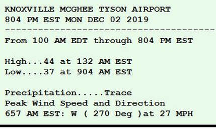 From NWS-Morristown It may start out as raindrops tonight, but eventually it will change over to snowflakes for many before sunrise Monday. Expect plenty of wind with blustery conditions. The mountains will receive the BULK of the snow accumulation, due to higher elevations and colder air...which will translate to BLOWING and DRIFTING SNOW high above. Not happy with your snowfall amounts? We've been horseshoed again. Thanks to the HORSESHOE EFFECT, higher hills get more. It's just the way it goes. Here's the snowfall I expect by 7 PM Monday, December 2nd. #CaptAccurateWx 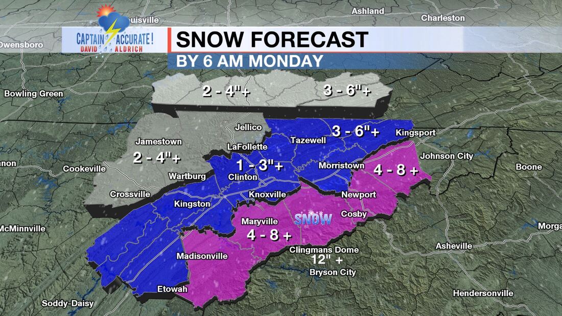 |
David AldrichCaptain Accurate Weather Archives
April 2024
Categories |
 RSS Feed