|
CAPTAIN ACCURATE'S WEATHER
TIMELINE |

|


|
Very little changes were made to this forecast. Please note: The changeover for the Plateau will occur this afternoon. By evening, temperatures will be cold enough in the Valley to see something, but just not much. This is NOT a big deal for the Valley because of the Horseshoe Effect (colder air exists in higher elevations). FROM NWS-MORRISTOWN... WINTER STORM WARNING IN EFFECT FROM 4 PM THIS AFTERNOON TO 7 AM EST THURSDAY... * WHAT...Heavy snow expected. Total snow accumulations of 4 to 8 inches, mainly at elevations above 2500 feet, with locally higher amounts possible over the highest elevations. Winds gusting as high as 35 mph at times. * WHERE...Cocke Smoky Mountains, Blount Smoky Mountains and Sevier Smoky Mountains Counties. * WHEN...From 4 PM this afternoon to 7 AM EST Thursday. * IMPACTS...Travel may become difficult due to snow covered roads and reduced visibility especially over the higher elevations. * ADDITIONAL DETAILS...Wind chill values will dip to between 0 and 10 degrees above at times tonight. URGENT - WINTER WEATHER MESSAGE National Weather Service Jackson KY Harlan County, KY Including the cities of Cumberland, Harlan, Jenkins, and Whitesburg 242 PM EST Wed Feb 26 2020 ...WINTER WEATHER ADVISORY IN EFFECT UNTIL 7 AM EST THURSDAY... * WHAT...Rain showers will change to snow showers through this evening. Snow showers will continue into early Thursday morning. Event total snow accumulations of generally less than one inch below 2500 feet and 1 to 2 inches at 2500 feet elevation and above are expected. Locally higher amounts are possible above 3000 feet. WHERE...Harlan County. WHEN...Until 7 AM EST Thursday. IMPACTS...Plan on slippery road conditions. The hazardous conditions could impact the morning or evening commute. PRECAUTIONARY/PREPAREDNESS ACTIONS... Slow down and use caution while traveling. 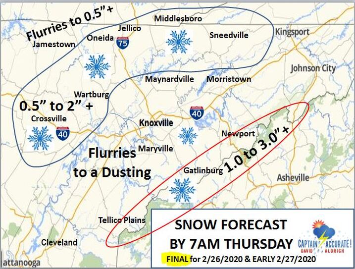  4 to 8" of SNOW is expected ABOVE 2,500 FEET with the Winter Storm Warning in the Smokies
0 Comments
Leave a Reply. |
David AldrichCaptain Accurate Weather Archives
July 2024
Categories |


 RSS Feed