|
CAPTAIN ACCURATE'S WEATHER
BLOG |

|


|
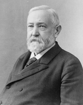
Friday: Plenty of clouds, some hazy sun, warm, some drizzle possible, highs in the mid 60s Friday night: Mostly cloudy, stray showers possible, warm, lows in the mid 50s Saturday: Mostly cloudy, some hazy sun, wind-driven showers, heavier toward evening, BEST chance for rain: 3 PM to 10 PM, isolated thunder, record breaking heat with highs in the lower to mid 70s. Knoxville's Record high on Saturday is in play: 72° (1890)...130 year old record ! Last time Knoxville was that warm on the 11th of January was when Benjamin Harrison was in the White House. Damaging wind possible Saturday Gusts in the Valley & Plateau: over 50 mph potentially. Gusts in the Smokies: over 70 + mph potentially. Cannot rule out an isolated tornado somewhere in East Tennessee. Today's model runs for rain suggest: Model A...0.55" Model B...0.78" Model C...0.75" 3 Model Average: 0.69" of potential rain late Friday into Saturday. Sunday: Mostly sunny, highs around 60° Monday: Partly cloudy, highs in the lower 60s So the weather does not surprise you #CaptAccurateWx P.S. If you find these independent forecasts and posts helpful, please consider downloading my NEW Captain Accurate Weather App. It's FREE. Just search: Captain Accurate at the App Store and Google Play. It comes with 5 FREE App Tutorials, so you can quickly learn all the wonderful things it can do.
0 Comments
Leave a Reply. |
David AldrichCaptain Accurate Weather Archives
April 2024
Categories |

 RSS Feed