|
CAPTAIN ACCURATE'S WEATHER
BLOG |

|


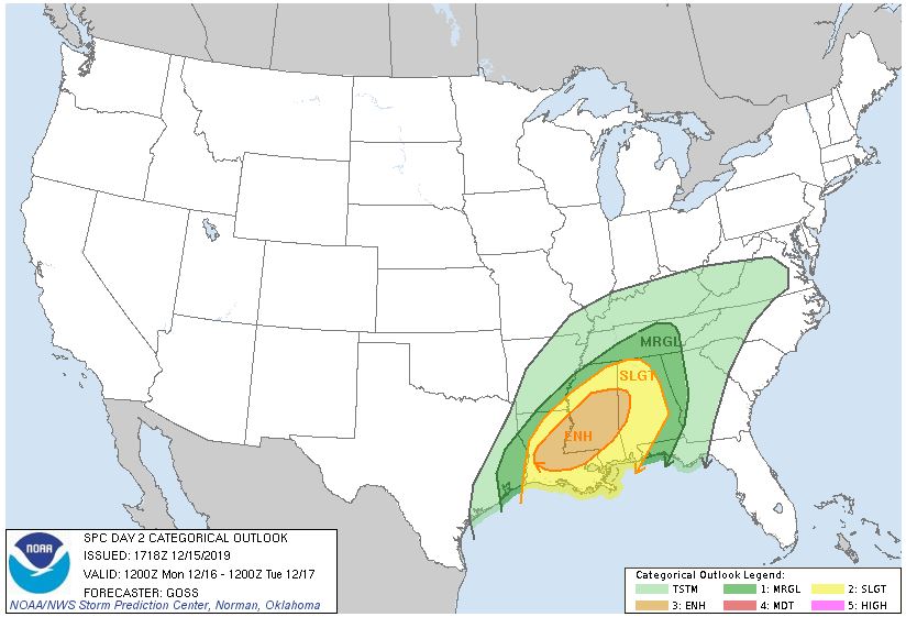 When a warning, watch or advisory is issued by the National Weather Service, how soon would you want to hear about it? The answer? Right away! Yet ANOTHER reason why having the Captain Accurate Weather App on your smartphone is key, especially this Monday. For example, you may have family in Mississippi, Louisiana or Alabama and may want to monitor their storms. Here is the Convective Outlook, as issued by the Storm Prediction Center, for Monday and Monday night. See map above. It puts the center of the severe storms in YELLOW (Slight Risk) over Mississippi, Louisiana and Alabama, where some tornadoes may occur. East Tennessee is under a "general thunderstorm risk" for Monday and Monday night, but of course, that could change, so stay tuned. There could be some localized flooding here in East Tennessee with strong gusty winds, especially for the Smokies by Monday evening. The Storm Prediction Center (SPC), based out of Norman, Oklahoma, covers the entire country and will use multiple labels and colors to describe their Outlooks. A good rule of thumb: MARGINAL risk (dark green) = Isolated severe storms SLIGHT risk (yellow) = Scattered severe storms ENHANCED risk (orange) = Numerous severe storms https://www.spc.noaa.gov/products/outlook/day3otlk.html Day 3 Convective Outlook CORR 1 NWS Storm Prediction Center Norman OK 0352 AM CST Sat Dec 14 2019 Valid 161200Z - 171200Z ...THERE IS A SLIGHT RISK OF SEVERE THUNDERSTORMS ACROSS FAR SOUTHEAST AR...EASTERN TX...MUCH OF LA...MS AND AL... CORRECTED FOR STATE ID TYPO ...SUMMARY... Isolated to scattered severe storms are expected Monday into Monday night from far eastern Texas into the lower Mississippi Valley and much of Mississippi and Alabama. Damaging wind gusts, a few tornadoes and isolated hail are all possible. ...Lower MS Valley into the Deep South Vicinity... Forecast guidance continues to trend deeper with the eastward-ejecting mid/upper trough moving across the Plains to the central U.S. on Monday. As a result, a weak surface low over AR during the morning is forecast to track more east/northeast into northern MS then into TN/KY. This will keep the warm sector confined further south across the lower MS Valley vicinity into the Gulf coast states. 60s F surface dewpoints will overspread much of the Gulf coast states ahead of an eastward-advancing cold front. Vertical shear continues to be impressive and supportive of supercells. Furthermore, latest forecast soundings from various guidance show some improvement in low level hodographs and convergence ahead of the front. This could act to increase tornado potential across parts of LA/MS/AL into the evening hours. However, deep layer southwesterly flow will generally be parallel to the surface front. As a result, a messy storm mode/evolution is expected with a mix of line segments/clusters and perhaps a few semi-discrete cells. MLCAPE will remain modest, around 500-750 J/kg, limited in part by cloud cover/weaker insolation. However, some areas that experience pockets of stronger heating could destabilize further. Midlevel lapse rates will be moderate, around 6.5-7.0 C/km and could result in some hail in more discrete modes. Otherwise, strong wind gusts and a few tornadoes (either from semi-discrete cells or via mesovortices in line segments) are expected. South and east extent of the Slight risk area remains somewhat in question given concerns over forcing, somewhat weaker shear and storms developing/moving into the area after peak heating. Therefore, expect some changes on the periphery of the Slight risk area in coming outlooks as details hopefully become clearer. ..Leitman.. 12/14/2019 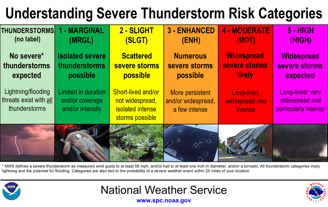 
0 Comments
Leave a Reply. |
David AldrichCaptain Accurate Weather Archives
April 2024
Categories |
 RSS Feed