|
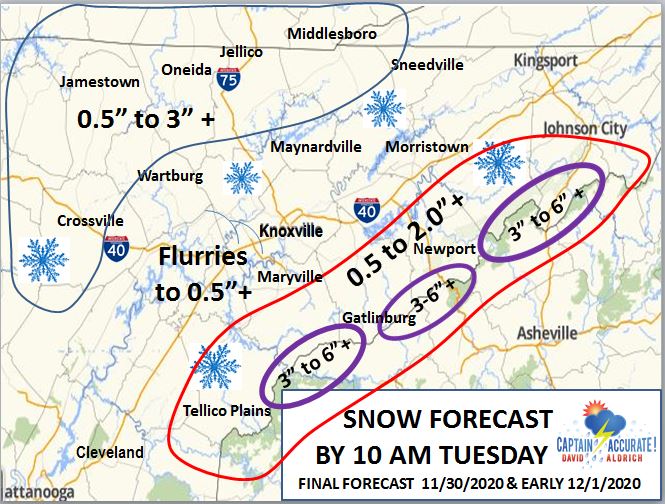
"My FINAL Forecast for this event" means I won't be changing this forecast in the morning.
RAIN, first COLD AIR, second SNOW, third I am still expecting 0.50" to 1.00" + of RAIN to fall first, starting this evening. But as we DROP through the 40s and into the 30s, a changeover will occur with SNOW sticking, mainly in the Plateau and in the Smokies, with stronger winds in the higher elevations. Some sleet (ice pellets) may be mixed in as well, as part of the transition. Just a heads up. Elevations above 5,000 feet (Mount LeConte, Clingmans Dome, Newfound Gap, for example) can expect 4 to 8" of snow with isolated 12" + amounts. ---- David Aldrich, "Captain Accurate" Watch my latest video here. P.S. If you find these independent forecasts and posts helpful, please consider supporting me by downloading my Captain Accurate Weather App. It's FREE with NEW BONUS Features like Baron Storm Tracks, Surface Analysis (Highs, Lows & Fronts), Day 1 to 3 Storm Prediction Center (SPC) Outlooks, and U.S. Drought Monitor (updated weekly). Just search: Captain Accurate at the App Store and Google Play. It comes with 7 FREE App Tutorials, so you can quickly learn all the wonderful things it can do. CLICK below or just search: Captain Accurate App Store https://apps.apple.com/us/app/captain-accurate-weather/id1488390368 Google Play https://play.google.com/store/apps/details?id=com.captainaccurate www.CaptainAccurate.com
0 Comments
Leave a Reply. |
David AldrichCaptain Accurate Weather Archives
July 2024
Categories |








 RSS Feed