|
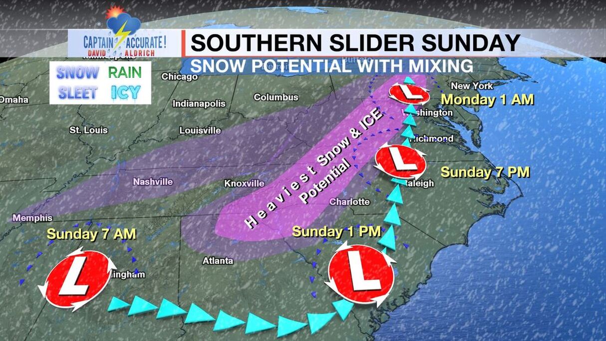
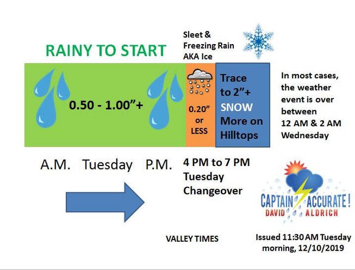
Here's what I expect in terms of snowfall, mostly on grassy surfaces, by 2 AM Wednesday. See map below. Take the higher number of my snowfall "range," if you live on a hill or on a higher elevation. I believe the storm timeline, (the second picture below), is still on target for the Valley...the changeover to winter weather will occur much sooner in the day Tuesday for the Plateau and Southeast Kentucky. Travelers, be advised.
If you find these forecasts helpful, then be sure to download my FREE Captain Accurate Weather App. The Data feature called "Future Radar (24-hours)" on the Captain Accurate Weather App works really well with weather events like this. Check it out. Just search: Captain Accurate at the App Store and on Google Play. It's FREE. Merry Christmas, East Tennessee. It's my gift to you! Thank you! The value of a forecast is not just what you say, but when you say it. #CaptAccurateWx www.CaptainAccurate.com
31 Comments
DONNA R JOHNSON
12/9/2019 02:44:41 pm
YOU RARELY SHOW UNION COUNTY..SHARPS CHAPEL...TAZEWELL...NEW TAZEWELL...MAYNARDVILLE,...
Reply
Shannon Phipps
12/9/2019 04:15:01 pm
What are you expecting for the Wears Valley area?
Reply
David Aldrich
12/9/2019 06:13:20 pm
Shannon, I am expecting around 2" for Wears Valley with more the higher up in elevation you go.
Timothy
12/9/2019 03:18:29 pm
What about new tazewell. I can't tell. Please let it be sime snow.
Reply
David Aldrich
12/9/2019 03:28:13 pm
Timothy, I am expecting a 1 to 3" of snow for New Tazewell and Claiborne County, mainly on grassy surfaces. This starts as rain then an icy mix then snow from Tuesday evening and ending before 5 AM Wednesday.
Reply
Louise
12/9/2019 03:18:54 pm
Good. We. Not. Going. To get. Snow
Reply
David Aldrich
12/9/2019 03:25:53 pm
I am expecting a trace to 2" of snow for Union County, mainly on grassy surfaces. This starts as rain then an icy mix then snow from Tuesday evening and ending before 5 AM Wednesday.
Reply
Connie Arms
12/9/2019 09:33:14 pm
Thank you David!
Reply
Sue Barger
12/9/2019 03:39:51 pm
How much you think Oakdale will get.thank you
Reply
David Aldrich
12/9/2019 03:47:58 pm
1 to 2" for Oakdale, isolated 3" for hilltops
Reply
Mindy Johnson
12/9/2019 04:15:52 pm
Thank you for everything! I've downloaded the app too. What a treat to get your forecasts again!!!
Reply
David Aldrich
12/9/2019 04:21:37 pm
Mindy, SO glad to have you !!!
Reply
Melissa Donehew
12/9/2019 04:22:08 pm
How much will South Knoxville get?
Reply
David Aldrich
12/9/2019 04:30:38 pm
Melissa, I expect South Knoxville to get what ALL of Knox County gets: A trace to 1" on grassy surfaces with isolated 2" amounts on hilltops.
Reply
Russ Partington
12/9/2019 05:24:29 pm
C'mon David..... We need more than that. You can do better!!😊
Reply
David Aldrich
12/9/2019 05:26:29 pm
Ha ! Russ.
Reply
Gabrielle fleming
12/9/2019 05:34:00 pm
What does it look like for Bybee TN and Newport TN
Reply
David Aldrich
12/9/2019 06:09:59 pm
Gabrielle, I am expecting around Trace to 1" for Bybee and around 2" for Newport with more the higher up in elevation you go.
Reply
Gabrielle Fleming
12/10/2019 04:23:49 pm
Thank you
Krista
12/9/2019 05:58:20 pm
What do you think about snow amounts in Walland? Will ice effect the roads Wednesday morning? We didn't get any snow the last time when it said 1-3 inches.
Reply
David Aldrich
12/9/2019 06:08:05 pm
Krista, I am expecting around 2" for Walland with more the higher up in elevation you go.
Reply
Krista
12/9/2019 06:34:27 pm
Will the ice be a problem on the roads Wednesday morning?
David Aldrich
12/9/2019 07:30:53 pm
Probably not, Krista. But as temperature flirt with 32° early Wednesday morning, bridges and overpasses may be slick in some spots. Just a heads up.
Lisa Collins
12/9/2019 06:02:41 pm
Thank you for this app! I just heard about it yesterday and kept going to Captain America(too much Big Bang Theory) til I got it correct. I love your weather forecasts- you were the one I depended on.
Reply
David Aldrich
12/9/2019 06:06:42 pm
Thank you, Lisa !
Reply
Gail
12/9/2019 06:44:31 pm
Thank you for all you do to keep us informed with the weather, I will thank you way more if you tell me Louisville Tn will at least get 2 inches lol. Thank again your the best!❄️
Reply
David Aldrich
12/9/2019 07:29:17 pm
Gail, I expect Louisville, TN to get what ALL of Knox County gets: A trace to 1" on grassy surfaces with isolated 2" amounts on hilltops.
Reply
D
12/9/2019 08:17:51 pm
What area does Caryville at the city limit /rocky top line fall in to? Are we the valley or the plateau?. Thanks for all you do !!!
Reply
David Aldrich
12/9/2019 08:34:37 pm
D, I would put you in the grassy 1 to 2” of snow with isolated 3” on hilltops.
Reply
D
12/10/2019 01:12:49 am
That's great !! But I mean what is this area considered when doing a forecast? We are always confused on what to expect. The valley or plateau? Upper valley? Southern plateau? Or are we just in a grey area haha
Reply
Mary Lou
12/10/2019 04:36:14 pm
Miss your Cock county /Greene county reports. I always got the Cock county snow when you reported it. So what's Cock county/Greene County line expecting?
Reply
Leave a Reply. |
David AldrichCaptain Accurate Weather Archives
July 2024
Categories |


 RSS Feed