|
CAPTAIN ACCURATE'S WEATHER
TIMELINE |

|


|
UPDATED 11:22 AM Sunday So weather does not surprise you #CaptAccurateWx This morning's LOW in Knoxville: 24° LOW this morning in Knoxville: 33° HIGH this afternoon in Knoxville: 42° Normal Low in Knoxville this time of year: 36° Normal High in Knoxville this time of year: 57° Today: Hazy sun, high clouds, warmer, highs in the upper 50s Tonight: Clouds thicken, not as cold, lows in the lower 40s Monday: Cloudy, rainy at times, 80% chance, highs in the mid 50s Monday night: Cloudy, more rain showers, 80% chance, mild, lows near 50° Tuesday: Cloudy, rainy at times, 80% chance, highs in the lower 60s For the latest 7 Day Forecast for Townsend, Clinton, Oneida or your town, check out the Captain Accurate Weather App. I also have a BRAND NEW horizontal 7 Day Forecast for Knoxville and a BRAND NEW Video, posted daily, on the home page of CaptainAccurate.com and on the Captain Accurate Weather App. Check it out here. Because Accurate forecasts don't grow on trees #CaptAccurateWx P.S. If you find these independent forecasts and posts helpful, please consider supporting me by downloading my NEW Captain Accurate Weather App. It's FREE. Just search: Captain Accurate at the App Store and Google Play. It comes with 5 FREE App Tutorials, so you can quickly learn all the wonderful things it can do. National Weather Service Morristown TN 250 PM EST Fri Feb 28 2020 ...WINTER STORM WARNING IN EFFECT UNTIL 7 AM EST SATURDAY... * WHAT...Heavy snow. Additional snow accumulations of 3 to 7 inches above 3500 feet. Lower elevations can expect 1 to 3 inches. WHERE...Above 3500 feet in Cocke Smoky Mountains, Blount Smoky Mountains, Sevier Smoky Mountains and Southeast Monroe Counties. WHEN...Until 7 AM EST Saturday. MPACTS...Travel will be hazardous due to snow covered roads and reduced visibility. ADDITIONAL DETAILS...Wind chill values tonight will drop into the single digits, with sub-zero values in the highest mountain peaks. PRECAUTIONARY/PREPAREDNESS ACTIONS... If you must travel, keep an extra flashlight, food, and water in your vehicle in case of an emergency. The latest road conditions for the state you are calling from can be obtained by calling 5 1 1. Gatlinburg's elevation: just under 1,300 feet Wears Valley's elevation: just under 1,500 feet National Weather Service Morristown TN 250 PM EST Fri Feb 28 2020 ...WINTER WEATHER ADVISORY REMAINS IN EFFECT UNTIL 7 AM EST SATURDAY... Scott-Campbell-Claiborne-Hancock-Johnson-Morgan-Southeast Greene- Unicoi-Southeast Carter-Lee-Wise-Russell- Including the cities of Big South Fork National, Oneida, Smokey Junction, Elgin, Huntsville, Norma, Slick Rock, Fincastle, La Follette, Elk Valley, Jellico, White Oak, Caryville, Royal Blue, Lone Mountain, Sandlick, Springdale, Arthur, Harrogate-Shawanee, Clairfield, Howard Quarter, Evanston, Sneedville, Kyles Ford, Doeville, Mountain City, Neva, Shady Valley, Trade, Laurel Bloomery, Pine Orchard, High Point, Petros, Cedar Creek, Erwin, Unicoi, Limestone Cove, Hampton, Rose Hill, Big Stone Gap, Norton, Wise, Coeburn, Appalachia, Pardee, Hansonville, Lebanon, Dye, Castlewood, Honaker, and Rosedale WHAT...Snow expected. Total snow accumulations of 1 to 3 inches above 2500 feet. Locally higher amounts are possible in the highest peaks. Up to 1 inch is possible in lower elevations. WHERE...Portions of East Tennessee and southwest Virginia at elevations above 2500 feet. WHEN...Until 7 AM EST Saturday. IMPACTS...Travel may be difficult due to snow covered roads and reduced visibility especially over the higher elevations. ADDITIONAL DETAILS...Wind chill values will dip to between 0 and 10 degrees above zero at times late tonight, with wind chill values below zero in the highest mountain peaks of East Tennessee. PRECAUTIONARY/PREPAREDNESS ACTIONS... Slow down and use caution while traveling. The latest road conditions for the state you are calling from can be obtained by calling 5 1 1. 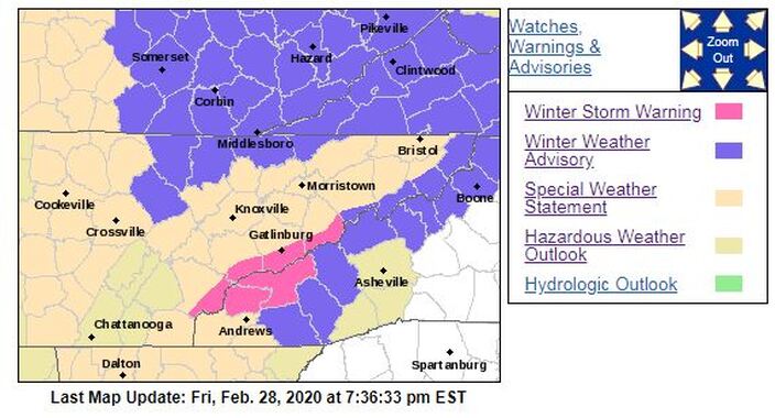
2 Comments
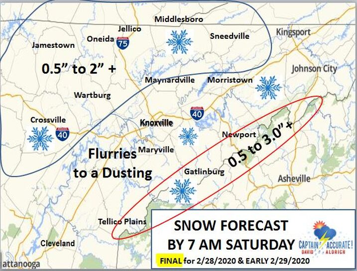 So weather does not surprise you #CaptAccurateWx Normal Low in Knoxville this time of year: 35° Normal High in Knoxville this time of year: 56° LOW this morning in Knoxville: 33° Today: Cloudy skies, morning snow showers, midday rain showers, 60% chance, highs in the lower to mid 40s SEE MY SNOW MAP ABOVE. BECAUSE THESE ARE WET SNOW SHOWERS, ANY ACCUMULATION IS MORE LIKELY TO APPEAR ON GRASSY SURFACES, AND NOT THE ROADS....unless you're in the Smokies. Tonight: Cloudy, wet snow showers and flurries, 40% chance, lows in the mid to upper 20s Saturday: 40% chance of wet snow showers early in the morning, becoming sunny, highs in the lower to mid 40s Saturday night; Starry skies, frosty cold, lows in the upper 20s Sunday: Mostly sunny, warmer, highs in the mid to upper 50s Sunday night: Increasing clouds, not as cold, lows in the lower 40s Monday: Cloudy, rain showers developing, 60% chance, highs in the mid 50s For the latest 7 Day Forecast for Oakdale, Norris, Jacksboro or your town, check out the Captain Accurate Weather App. I also have a BRAND NEW horizontal 7 Day Forecast for Knoxville and a BRAND NEW Video, posted daily, on the home page of CaptainAccurate.com and on the Captain Accurate Weather App. Check it out here. Because Accurate forecasts don't grow on trees #CaptAccurateWx P.S. If you find these independent forecasts and posts helpful, please consider supporting me by downloading my NEW Captain Accurate Weather App. It's FREE. Just search: Captain Accurate at the App Store and Google Play. It comes with 5 FREE App Tutorials, so you can quickly learn all the wonderful things it can do. National Weather Service Nashville TN 241 PM CST Thu Feb 27 2020 ...Snowfall Accumulations Expected Across Higher Elevations of Cumberland Plateau Region Friday Morning.. .As an upper level system moves across the Cumberland Plateau Region during morning hours on Friday, light snowfall accumulation will occur. For higher elevations of Cumberland Plateau Region, elevations around 1,500 feet or greater, snowfall accumulation amounts from one up to two inches are expected. Pickett-Putnam-Overton-Fentress-White-Cumberland-Warren-Grundy- Van Buren- Including the cities of Byrdstown, Cookeville, Livingston, Jamestown, Allardt, Sparta, Crossville, McMinnville, Altamont, Coalmont, and Spencer 241 PM CST Thu Feb 27 2020 ...WINTER WEATHER ADVISORY IN EFFECT FROM 4 AM TO NOON CST FRIDAY... * WHAT...Snow expected. Total snow accumulations of one up to two inches. * WHERE...Higher elevations of Cumberland Plateau Region of Middle Tennessee. * WHEN...From 4 AM to noon CST Friday. IMPACTS...Plan on slippery road conditions. The hazardous conditions could impact the morning commute. PRECAUTIONARY/PREPAREDNESS ACTIONS... Slow down and use caution while traveling. The latest road conditions for the state you are calling from can be obtained by calling 5 1 1. National Weather Service Morristown TN 305 PM EST Thu Feb 27 2020 Johnson-Cocke Smoky Mountains-Southeast Greene-Unicoi- Southeast Carter-Blount Smoky Mountains-Sevier Smoky Mountains- Southeast Monroe-Wise- Including the cities of Doeville, Mountain City, Neva, Shady Valley, Trade, Laurel Bloomery, Hartford, Cedar Creek, Erwin, Unicoi, Limestone Cove, Hampton, Cades Cove, Elkmont, Gatlinburg, Citico, Coker Creek, Big Stone Gap, Norton, Wise, Coeburn, Appalachia, and Pardee 305 PM EST Thu Feb 27 2020 ...WINTER WEATHER ADVISORY IN EFFECT FROM 7 AM FRIDAY TO 10 AM EST SATURDAY... * WHAT...Snow expected. Total snow accumulations of 3 to 6 inches above 2500 feet. Locally higher amounts are possible in the highest peaks. * WHERE...Portions of east Tennessee and southwest Virginia elevations above 2500 feet. * WHEN...From 7 AM Friday to 10 AM EST Saturday. * IMPACTS...Travel may be difficult due to snow covered roads and reduced visibility especially over the higher elevations. * ADDITIONAL DETAILS...Wind chill values will dip to between 0 and 10 degrees above at times tonight. PRECAUTIONARY/PREPAREDNESS ACTIONS... Slow down and use caution while traveling. The latest road conditions for the state you are calling from can be obtained by calling 5 1 1. Gatlinburg's elevation: just under 1,300 feet Wears Valley's elevation: just under 1,500 feet National Weather Service Jackson KY 339 PM EST Thu Feb 27 2020 Bell-Harlan- Including the cities of Middlesboro, Pineville, Cumberland, Harlan, Jenkins, and Whitesburg 339 PM EST Thu Feb 27 2020 ...WINTER WEATHER ADVISORY IN EFFECT FROM 5 AM FRIDAY TO 7 AM EST SATURDAY... * WHAT...Two rounds of light snow are expected. Around 1 inch of snow is expected from late tonight through noon on Friday with the first round. 1 to 2 inches of snow is then expected Friday evening through early Saturday morning with the second round. The highest accumulations and greatest travel impacts should occur for locations above 2000 feet. * WHERE...Bell and Harlan Counties. * WHEN...From 5 AM Friday to 7 AM EST Saturday. * IMPACTS...Plan on slippery road conditions, especially on roads above 2000 feet elevation. The hazardous conditions could impact the Friday morning commute. PRECAUTIONARY/PREPAREDNESS ACTIONS... Slow down and use caution while traveling. 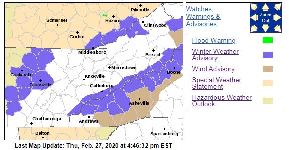 From NWS-Morristown
What are you seeing tonight? A) Absolutely nothing B) Some Rain or Drizzle C) Some Snow Showers or Flurries  Very little changes were made to this forecast. Please note: The changeover for the Plateau will occur this afternoon. By evening, temperatures will be cold enough in the Valley to see something, but just not much. This is NOT a big deal for the Valley because of the Horseshoe Effect (colder air exists in higher elevations). FROM NWS-MORRISTOWN... WINTER STORM WARNING IN EFFECT FROM 4 PM THIS AFTERNOON TO 7 AM EST THURSDAY... * WHAT...Heavy snow expected. Total snow accumulations of 4 to 8 inches, mainly at elevations above 2500 feet, with locally higher amounts possible over the highest elevations. Winds gusting as high as 35 mph at times. * WHERE...Cocke Smoky Mountains, Blount Smoky Mountains and Sevier Smoky Mountains Counties. * WHEN...From 4 PM this afternoon to 7 AM EST Thursday. * IMPACTS...Travel may become difficult due to snow covered roads and reduced visibility especially over the higher elevations. * ADDITIONAL DETAILS...Wind chill values will dip to between 0 and 10 degrees above at times tonight. URGENT - WINTER WEATHER MESSAGE National Weather Service Jackson KY Harlan County, KY Including the cities of Cumberland, Harlan, Jenkins, and Whitesburg 242 PM EST Wed Feb 26 2020 ...WINTER WEATHER ADVISORY IN EFFECT UNTIL 7 AM EST THURSDAY... * WHAT...Rain showers will change to snow showers through this evening. Snow showers will continue into early Thursday morning. Event total snow accumulations of generally less than one inch below 2500 feet and 1 to 2 inches at 2500 feet elevation and above are expected. Locally higher amounts are possible above 3000 feet. WHERE...Harlan County. WHEN...Until 7 AM EST Thursday. IMPACTS...Plan on slippery road conditions. The hazardous conditions could impact the morning or evening commute. PRECAUTIONARY/PREPAREDNESS ACTIONS... Slow down and use caution while traveling. 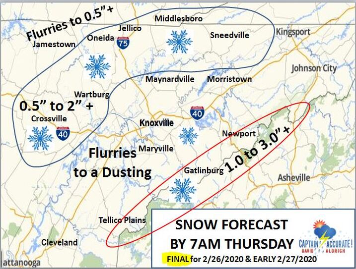 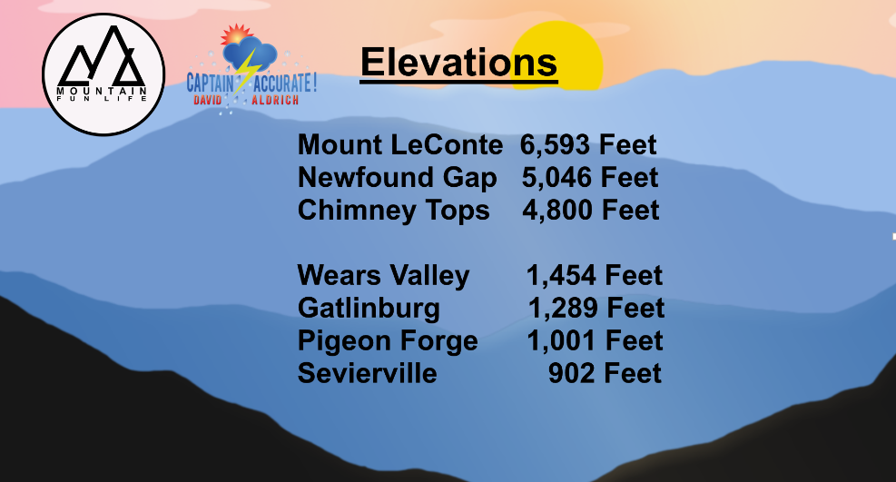 4 to 8" of SNOW is expected ABOVE 2,500 FEET with the Winter Storm Warning in the Smokies
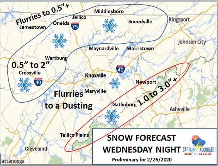 UPDATED 9:11 AM Wednesday So weather does not surprise you #CaptAccurateWx Normal Low in Knoxville this time of year: 34° Normal High in Knoxville this time of year: 56° FROM NWS-MORRISTOWN...WINTER WEATHER ADVISORIES FOR THE SMOKIES FROM 4 PM TODAY TO 7 AM THURSDAY for the possibility of 1 to 5", with the higher amounts in the highest elevations. *** I am expecting roughly 0.25" of rain or LESS to fall today in East Tennessee before it changes over to flurries and snow showers. To know what to expect in terms of snow, see my snow map above. *** Today: Becoming cloudy, 60% chance of rain showers that could change to snow by later Wednesday evening, (Plateau should change to snow in the afternoon), highs in the upper 40s to lower 50s Tonight: Rain to wet snow showers & flurries possible, 40% chance, otherwise, mostly cloudy, lows in the upper 20s to near 30° Thursday: Becoming mostly sunny, cold highs in the lower to mid 40s Thursday night: Increasing clouds, colder, lows in the upper 20s to near 30° Friday: Mostly cloudy, spots of rain and snow, 20% chance, highs in the lower to mid 40s Friday night: Cloudy, wet snow showers, 40% chance, lows in the upper 20s Saturday: 40% chance of wet snow showers early in the morning, becoming mostly sunny, highs in the mid 40s Saturday night; Mostly clear, not as cold, lows in the lower 30s Sunday: Mostly sunny, warmer, highs around 60° For the latest 7 Day Forecast for Rutledge, Sneedville, Morristown or your town, check out the Captain Accurate Weather App. I also have a BRAND NEW horizontal 7 Day Forecast for Knoxville and a BRAND NEW Video, posted daily, on the home page of CaptainAccurate.com and on the Captain Accurate Weather App. Check it out here. Because Accurate forecasts don't grow on trees #CaptAccurateWx P.S. If you find these independent forecasts and posts helpful, please consider supporting me by downloading my NEW Captain Accurate Weather App. It's FREE. Just search: Captain Accurate at the App Store and Google Play. It comes with 5 FREE App Tutorials, so you can quickly learn all the wonderful things it can do.
UPDATED 10:48 AM Tuesday The value of a forecast is not just what you say, but when you say it #CaptAccurateWx Normal Low in Knoxville this time of year: 34° Normal High in Knoxville this time of year: 55° Today: Clouds to hazy sun and warm, breezy, gusts to 25 mph, highs in the lower to mid 60s Tonight: Increasing clouds, lows in the lower to mid 40s Wednesday: Mostly cloudy, 60% chance of rain showers that could change to snow by later Wednesday night, highs in the lower 50s Wednesday night: Rain to wet snow showers possible, 20% chance, otherwise, mostly cloudy, lows in the upper 20s Thursday: Becoming mostly sunny, cold highs in the lower to mid 40s Thursday night: Increasing clouds, colder, lows in the upper 20s to near 30° Friday: Mostly cloudy, spots of rain and snow, 20% chance, highs in the mid 40s Friday night: Cloudy, wet snow showers, 40% chance, lows in the upper 20s Saturday: Partly sunny, 40% chance of wet snow showers, especially in the morning, highs in the lower 40s For the latest 7 Day Forecast for Townsend, Clarkrange, Dandridge or your town, check out the Captain Accurate Weather App. I also have a BRAND NEW horizontal 7 Day Forecast for Knoxville and a BRAND NEW Video, posted daily, on the home page of CaptainAccurate.com and on the Captain Accurate Weather App. Check it out here. Because Accurate forecasts don't grow on trees #CaptAccurateWx P.S. If you find these independent forecasts and posts helpful, please consider supporting me by downloading my NEW Captain Accurate Weather App. It's FREE. Just search: Captain Accurate at the App Store and Google Play. It comes with 5 FREE App Tutorials, so you can quickly learn all the wonderful things it can do.
UPDATED at 8:34 AM Monday So weather does not surprise you #CaptAccurateWx Future Rainfall for Monday and Early Tuesday: 0.67" on average, based on today's model data Today: Cloudy, rainy at times, 80% chance, some sleet may mix in as well, highs near 50° Tonight: More rain showers, 80% chance, rumble of thunder possible during the evening, lows in the mid 40s Tuesday: Early morning rain showers, 40% chance, clouds to hazy sun and warm, highs in the mid 60s Tuesday night: Mostly cloudy, lows in the lower 40s Wednesday: Mostly cloudy, 60% chance of rain showers that could change to snow by later Wednesday night, highs in the upper 40s. Wednesday night: Rain to wet snow showers possible, 20% chance, otherwise, mostly cloudy, lows in the upper 20s Thursday: Early flurries fade, 20% chance, then bright sunshine, cold highs in the lower to mid 40s For the latest 7 Day Forecast for Walland, Fairfield Glade, Jellico or your town, check out the Captain Accurate Weather App. I also have a BRAND NEW horizontal 7 Day Forecast for Knoxville and a BRAND NEW Video, posted daily, on the home page of CaptainAccurate.com and on the Captain Accurate Weather App. Check it out here. Because Accurate forecasts don't grow on trees #CaptAccurateWx P.S. If you find these independent forecasts and posts helpful, please consider supporting me by downloading my NEW Captain Accurate Weather App. It's FREE. Just search: Captain Accurate at the App Store and Google Play. It comes with 5 FREE App Tutorials, so you can quickly learn all the wonderful things it can do.
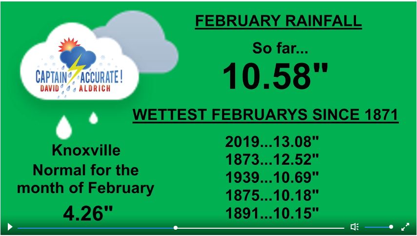 February 2020 is likely to finish in the TOP 3 WETTEST FEBRUARYS SINCE 1871 in Knoxville's Record Keeping. Source: NWS-Morristown  I showed this image on November 5th, 2019 in my Winter Weather Outlook...on the Home Page of CaptainAccurate.com 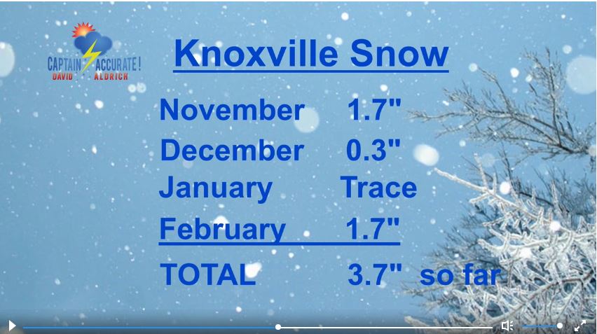 Snow Totals for Knoxville 2019 to 2020 so far. 1.6" is the normal for February. Last winter, Knoxville received only 2.1" of snow. Because Accurate forecasts don't grow on trees #CaptAccurateWx UPDATED 11:25 AM Sunday THIS MORNING'S LOW IN KNOXVILLE: 29° Normal low for this time of year: 34° Normal high for this time of year: 55° Today: Hazy sun in the morning, increasing clouds in the afternoon, 20% chance for spotty rain by evening, highs in the mid 50s Tonight: Mostly cloudy, more rain develops late, 60% chance, lows near 40° Monday: Cloudy, rainy at times, 80% chance, highs in the lower 50s Monday night: More rain showers, 80% chance, lows in the mid 40s Tuesday: Early morning rain showers, 40% chance, then becoming partly cloudy and warm, highs in the lower to mid 60s Tuesday night: Mostly cloudy, spotty rain, 20% chance, lows in the lower 40s Wednesday: Mostly cloudy, 60% chance of rain showers that could change to snow by later Wednesday night, highs in the lower 50s For the latest 7 Day Forecast for Seymour, Clinton, Bean Station or your town, check out the Captain Accurate Weather App. I also have a BRAND NEW horizontal 7 Day Forecast for Knoxville and a BRAND NEW Video, posted daily, on the home page of CaptainAccurate.com and on the Captain Accurate Weather App. Check it out here. So weather does not surprise you #CaptAccurateWx P.S. If you find these independent forecasts and posts helpful, please consider supporting me by downloading my NEW Captain Accurate Weather App. It's FREE. Just search: Captain Accurate at the App Store and Google Play. It comes with 5 FREE App Tutorials, so you can quickly learn all the wonderful things it can do.
Updated 11:07 AM Saturday Because Accurate forecasts don't grow on trees #CaptAccurateWx Normal low for this time of year: 34° Normal high for this time of year: 54° Today: Bright sunshine, milder in the afternoon, highs in lower to mid 50s Tonight: Plenty of stars & cold, lows in the upper 20s Sunday: Mostly sunny in the morning, increasing clouds in the afternoon, 20% chance for spotty rain by evening, highs in the mid 50s Sunday night: Mostly cloudy, more rain develops late, 60% chance, lows near 40° Monday: Cloudy, periods of rain, 80% chance, highs in the lower 50s Monday night: More rain showers, 80% chance, lows in the mid 40s Tuesday: Early morning rain showers, 40% chance, then becoming partly cloudy and warm, highs in the lower 60s For the latest 7 Day Forecast for Maynardville, Karns, Jamestown or your town, check out the Captain Accurate Weather App. I also have a BRAND NEW horizontal 7 Day Forecast for Knoxville and a BRAND NEW Video, posted daily, on the home page of CaptainAccurate.com and on the Captain Accurate Weather App. Check it out here. So weather does not surprise you #CaptAccurateWx P.S. If you find these independent forecasts and posts helpful, please consider supporting me by downloading my NEW Captain Accurate Weather App. It's FREE. Just search: Captain Accurate at the App Store and Google Play. It comes with 5 FREE App Tutorials, so you can quickly learn all the wonderful things it can do.
When I was in college at North Carolina State University, I was told a great forecaster is one who goes back AFTER a weather event is over...and asks himself, what could I have done differently or what more could I have looked at...and at what angle...to have improved the forecast? Well, if you look at the ACTUAL data from McGhee Tyson Airport yesterday, Knoxville received 0.24" of liquid, when only SNOW was being reported. IF we were just 3° COLDER on Thursday during that time, we would have received roughly 2.4" of SNOW in Knoxville, rather than 0.7" of SNOW that was reported. Take Fairfield Glade, Cumberland County (Plateau), for example, they got 3.0" of SNOW on Thursday. It's no surprise to me because the Plateau is usually 3° to 5° COLDER than the Valley on any given day. Hope this helps. Captain Accurate 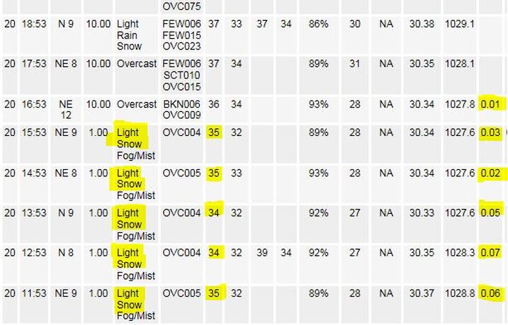 NWS Weather Observations from McGhee Tyson Airport for parts of Thursday, February 20, 2020 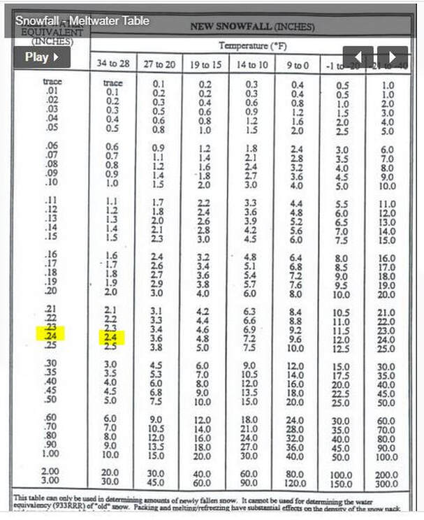 You can find this chart on "My Weather Toolbox" on the Home page of CaptainAccurate.com Updated 8:39 AM Friday So weather does not surprise you #CaptAccurateWx Normal low for this time of year: 34° Normal high for this time of year: 54° Today: Sunshiny skies, cold, highs in the upper 30s to near 40° Friday night: Clear and cold, lows near 20° Saturday: Bright sunshine, milder in the afternoon, highs in lower 50s Saturday night: Mostly clear & cold, lows in the upper 20s Sunday: Partly cloudy, 20% chance for spotty rain by evening, highs in the mid 50s Sunday night: Clouds increase, more rain develops late, 60% chance, lows in the upper 30s Monday: Cloudy, periods of rain, 80% chance, highs in the lower 50s For the latest 7 Day Forecast for Kingston, Fairfield Glade, Dandridge or your town, check out the Captain Accurate Weather App. I also have a BRAND NEW horizontal 7 Day Forecast for Knoxville and a BRAND NEW Video, posted daily, on the home page of CaptainAccurate.com and on the Captain Accurate Weather App. Check it out here. It's not easy being Accurate #CaptAccurateWx P.S. If you find these independent forecasts and posts helpful, please consider supporting me by downloading my NEW Captain Accurate Weather App. It's FREE. Just search: Captain Accurate at the App Store and Google Play. It comes with 5 FREE App Tutorials, so you can quickly learn all the wonderful things it can do.
Track the wet snow today using the Captain Accurate Weather App. It's FREE at the App Store and Google Play. App Store https://apps.apple.com/us/app/captain-accurate-weather/id1488390368 Google Play https://play.google.com/store/apps/details?id=com.captainaccurate
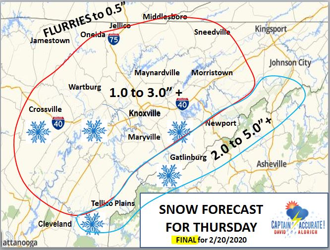
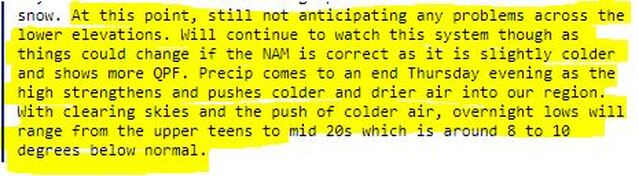
“Ladies and gentlemen, please remain seated until the Captain turns off the Fasten Seat Belt sign.” It's going to be a "wet snow" ride. The aggressive NAM (North American Mesoscale) model, generated here in the United States, still has 3 to 4" + of wet snow for Knoxville and its surrounding East Tennessee counties for Thursday. That means expect accumulation, especially on grassy surfaces, patio, deck furniture and cold car roof tops, for example. Snow covered roads are more likely to develop in the Smokies where it's naturally colder. Model Timeline for Knoxville: 6 AM to 9 AM......RAIN (yes, rain) 10 AM to 5 PM....WET SNOW (yes, wet snow) and FLURRIES This model output comes from tonight's 7 PM run. Just a heads up. My FINAL Snow Map has NOT changed. See below. It was posted just before 4 PM today, and is located here on CaptainAccurate.com. ---signed Captain Accurate  For context... Last time Knoxville had a 1.0" of snow was fairly recent: 1.0"...February 8, 2020 Last time Knoxville had over 1.5" of snow: 1.7"...November 12, 2019 Last time Knoxville had 3.0" of snow in one day was 5 years ago: 3.0"...February 24, 2015 Last time Knoxville had over 4.0" of snow in one day was also 5 years ago 4.3"...February 25, 2015 Of course, these last two snow events above equaled a 7.3" snow in Knoxville over the period of 2 days. From NWS-Morristown... Here's the TOP 10 SNOWFALLS in Knoxville's weather history Knoxville 1...18.8 inches: February 12-14, 1960 2...18.2 inches: November 20-22, 1952 3...14.7 inches: March 12-14, 1993 4...12.7 inches: March 1-3, 1942 5...12.0 inches: January 8-10, 1962 6...10.7 inches: April 2-4, 1987 7...9.9 inches: January 28-30, 1966 8...9.8 inches: December 31-January 1, 1963-1964 9...9.4 inches: January 22-24, 1940 10...9.0 inches: January 7-8, 1973 https://www.weather.gov/mrx/snow 
   The value of a forecast is not just what you say, but when you say it #CaptAccurateWx TODAY'S HIGH IN KNOXVILLE: 52° TODAY'S LOW IN KNOXVILLE: 45° Tonight: Clouds increase, lows in the upper 30s Thursday: Cloudy & colder, some rain possible, but mostly wet snow showers and flurries, 80% chance, accumulation possible, see my snow map above, early highs in the lower 40s...most of the day spent FALLING through the 30s. Thursday night: Mostly cloudy, evening wet snow showers and flurries taper, 40% chance, turning frigid, lows in the upper teens. Friday: Sunshiny skies, cold, highs in the upper 30s to near 40° Friday night: Clear and cold, lows in the lower 20s Saturday: Bright sunshine, milder in the afternoon, highs in lower 50s Saturday night: Mostly clear & cold, lows in the upper 20s Sunday: Partly cloudy, 20% chance for spotty rain at night, highs in the mid 50s For the latest 7 Day Forecast for Wartburg, Oneida, Jefferson City or your town, check out the Captain Accurate Weather App. I also have a BRAND NEW horizontal 7 Day Forecast for Knoxville and a BRAND NEW Video, posted daily, on the home page of CaptainAccurate.com and on the Captain Accurate Weather App. Check it out here. Because all forecasts are not created equal #CaptAccurateWx P.S. If you find these independent forecasts and posts helpful, please consider supporting me by downloading my NEW Captain Accurate Weather App. It's FREE. Just search: Captain Accurate at the App Store and Google Play. It comes with 5 FREE App Tutorials, so you can quickly learn all the wonderful things it can do.
The aggressive NAM (North American Mesoscale) model, generated here in the United States, has 3 to 4" + of snow for Knoxville and its surrounding East Tennessee counties for this Thursday. This model output comes from tonight's 7 PM run. Just a heads up. My FINAL Snow Map will still come out Wednesday afternoon. Stay tuned. ---signed Captain Accurate
   Tonight: Rain showers continue, steady and heavy at times, 80% chance, lows in the lower 40s Wednesday: Spots of morning rain fade quickly, 20% chance, otherwise clouds to sun, highs in the lower 50s Wednesday night: Clouds increase, lows in the mid to upper 30s Thursday: Cloudy & colder, some rain possible, but mostly wet snow showers and flurries, 80% chance, accumulation possible, see my snow map above, highs in the lower 40s...most of the day spent in the 30s. Thursday night: Mostly cloudy, evening wet snow showers and flurries taper, 80% chance, accumulation possible, lows in the lower 20s. Friday: Sunshiny skies, cold, highs in the lower 40s Friday night: Mostly clear, lows in the mid 20s Saturday: Bright sunshine, milder in the afternoon, highs in lower 50s For the latest 7 Day Forecast for Kingston, Lenoir City, Sneedville or your town, check out the Captain Accurate Weather App. I also have a BRAND NEW horizontal 7 Day Forecast for Knoxville and a BRAND NEW Video, posted daily, on the home page of CaptainAccurate.com and on the Captain Accurate Weather App. Check it out here. Because all forecasts are not created equal #CaptAccurateWx P.S. If you find these independent forecasts and posts helpful, please consider supporting me by downloading my NEW Captain Accurate Weather App. It's FREE. Just search: Captain Accurate at the App Store and Google Play. It comes with 5 FREE App Tutorials, so you can quickly learn all the wonderful things it can do.
Updated 9:45 AM Tuesday Normal high and low in Knoxville on Tuesday: 53° / 33° Morning low in Knoxville Today: 50° Today: Cloudy, rainy at times, 80% chance, 0.50 to 0.75" of rain on average with locally higher amounts, isolated thunder in the afternoon, warm, highs in the lower 60s Tonight: Rain showers continue, steady and heavy at times, 80% chance, isolated thunder for the evening, lows in the lower 40s Wednesday: Early morning rain showers fade, 20% chance, otherwise clouds to sun, highs in the lower 50s Wednesday night: Clouds increase, lows in the upper 30s Thursday: Mainly gray, colder, light rain to wet snow showers and flurries possible, 60% chance, accumulation possible, highs in the lower to mid 40s Thursday night: Mostly cloudy, wet snow showers and flurries possible, 60% chance, accumulation possible, lows in the lower 20s. Friday: Sunshiny skies, chilly, highs in the lower to mid 40s For the latest 7 Day Forecast for Harriman, Seymour, Strawberry Plains or your town, check out the Captain Accurate Weather App. I also have a BRAND NEW horizontal 7 Day Forecast for Knoxville and a BRAND NEW Video, posted daily, on the home page of CaptainAccurate.com and on the Captain Accurate Weather App. Check it out here. Because all forecasts are not created equal #CaptAccurateWx P.S. If you find these independent forecasts and posts helpful, please consider supporting me by downloading my NEW Captain Accurate Weather App. It's FREE. Just search: Captain Accurate at the App Store and Google Play. It comes with 5 FREE App Tutorials, so you can quickly learn all the wonderful things it can do.
Normal high and low in Knoxville on Presidents Day: 53° / 33° Today / Presidents Day / Washington's Birthday: Sunshine, some high clouds, dry and warm, highs in the mid 60s Record high...way out of reach...79° (1927) Tonight: Clouds thicken, showers develop late, 40% chance, lows in the upper 40s Tuesday: Cloudy, rainy at times, 80% chance, about a third of an inch, isolated thunder, warm, highs in the lower 60s Tuesday night: More rain showers, isolated thunder, lows in the lower 40s Wednesday: Early rain showers, 20% chance, otherwise mostly cloudy, highs in the lower 50s Wednesday night: Mostly cloudy, lows in the upper 30s Thursday: Partly sunny, colder, spotty rain to snow possible, 20% chance, highs in the mid 40s For the latest 7 Day Forecast for your town, check out the Captain Accurate Weather App. I also have a BRAND NEW horizontal 7 Day Forecast for Knoxville and a BRAND NEW Video, posted daily, on the home page of CaptainAccurate.com and on the Captain Accurate Weather App. Check it out here. When your forecast matters #CaptAccurateWx P.S. If you find these independent forecasts and posts helpful, please consider supporting me by downloading my NEW Captain Accurate Weather App. It's FREE. Just search: Captain Accurate at the App Store and Google Play. It comes with 5 FREE App Tutorials, so you can quickly learn all the wonderful things it can do.
Today: Mostly cloudy, some sprinkles possible late in the afternoon or evening, highs in the mid 50s Tonight: Mostly cloudy, lows in the upper 30s Monday / Presidents Day: Mix of clouds and sun, highs in the lower 60s Monday night: Clouds thicken, lows in the upper 40s to near 50° Tuesday: Cloudy, periods of rain, 80% chance, about a half inch or less, isolated thunder, warm, highs in the lower to mid 60s Tuesday night: More rain showers, isolated thunder, lows in the lower 40s Wednesday: Early rain showers, 20% chance, otherwise mostly cloudy, highs in the lower 50s For the latest 7 Day Forecast for your town, check out the Captain Accurate Weather App. I also have a BRAND NEW horizontal 7 Day Forecast for Knoxville and a BRAND NEW Video, posted daily, on the home page of CaptainAccurate.com and on the Captain Accurate Weather App. Check it out here. When your forecast matters #CaptAccurateWx P.S. If you find these independent forecasts and posts helpful, please consider supporting me by downloading my NEW Captain Accurate Weather App. It's FREE. Just search: Captain Accurate at the App Store and Google Play. It comes with 5 FREE App Tutorials, so you can quickly learn all the wonderful things it can do.
|
David AldrichCaptain Accurate Weather Archives
July 2024
Categories |


 RSS Feed