|
CAPTAIN ACCURATE'S WEATHER
BLOG |

|


|
Sunday: Morning rain fades quickly. Early clouds to sun. Windy. Gusts 40-45+ mph around midday, even higher gusts on hilltops. Highs in the upper 50s to lower 60s. Sunday night: Mostly cloudy. Spotty rain returns in the Valley. Turning to snow for the Smokies and parts of Southeast Kentucky (higher elevations), lows in the mid-30s. Monday: Gray skies. Some light rain & drizzle. Even some wet snow flurries are possible in the Valley. No accumulation for the Valley expected. Highs in the lower 40s. Plateau: Trace to 0.5" + may fall, even less will stick. Looking for 1 to 3 inches + of snow for the Smokies & Harlan County, KY. It's not easy being Accurate #CaptAccurateWx URGENT - WEATHER MESSAGE National Weather Service Morristown TN 311 PM EST Sat Nov 30 2019 Cocke Smoky Mountains-Southeast Greene-Blount Smoky Mountains- Sevier Smoky Mountains-Southeast Monroe- Including the cities of Hartford, Cedar Creek, Cades Cove, Elkmont, Gatlinburg, Citico, and Coker Creek 311 PM EST Sat Nov 30 2019 ...WIND ADVISORY IN EFFECT FROM 10 PM THIS EVENING TO 7 AM EST SUNDAY... * WHAT...South winds 25 to 40 mph with gusts up to 55 mph expected. * WHERE...Cocke Smoky Mountains, Southeast Greene, Blount Smoky Mountains, Sevier Smoky Mountains and Southeast Monroe Counties. * WHEN...From 10 PM this evening to 7 AM EST Sunday. * IMPACTS...Gusty winds could blow around unsecured objects. Tree limbs could be blown down and a few power outages may result. * ADDITIONAL DETAILS...Rainfall will also lead to loose soil. This will enhance the potential of downed trees across the higher elevations. PRECAUTIONARY/PREPAREDNESS ACTIONS... Use extra caution when driving, especially if operating a high profile vehicle. Secure outdoor objects. 
0 Comments
Vanderbilt Commodores (3-8) @ Tennessee Volunteers (6-5) Saturday, November 30th Senior Day Salute to Service Game Neyland Stadium Knoxville, TN Televised on SEC Network 4 PM Kickoff........5:22 PM Sunset Cloudy, rain showers start light...turning into moderate to heavy rain as afternoon becomes evening, 60% chance (more downpours especially AFTER the game) Upper 50s for kickoff Mid to upper 50s halftime Mid 50s by the end of the game VRB / SW winds 5-10 mph #GoVols #GBO #CaptAccurateWx Credit: Ron Mulig for the cool artwork  Tonight, more clouds, showers develop, especially late. Any thunder should be isolated. Lows in the upper 40s to near 50....but temperature RISE by morning. Travel Wednesday, morning showers fade quickly, afternoon sun and wind, GUSTY WINDS around 35 mph, highs in the mid to upper-60s Thanksgiving, COLD MORNING (lower to mid-30s), DRY TURKEY, hazy sun, scattered clouds, cooler, highs in the lower 50s Black Friday, mostly cloudy, highs in the mid to upper 50s Saturday, mostly cloudy, a few showers for the VOLS game against Vanderbilt at 4 PM, highs in the lower to mid-60s “Give thanks to the LORD, for He is good; His love endures forever.” 1 Chronicles 16:34 #CaptAccurateWx  FROM NWS-MORRISTOWN ...WIND ADVISORY IN EFFECT FROM 1 AM TO 6 PM WEDNESDAY... * WHAT...Southwest winds 15 to 25 mph with gusts up to 45 mph expected. * WHERE...Portions of east Tennessee and southwest Virginia. * WHEN...From 1 AM to 6 PM EST Wednesday. Expect advisory level winds to begin in the higher elevations of the northern plateau, southwest Virginia, and east Tennessee mountains late tonight. Advisory level winds should spread into the lower elevations of the northern Tennessee valley and southwest Virginia around or shortly after daybreak Wednesday morning. * IMPACTS...Gusty winds could blow around unsecured objects. Tree limbs could be blown down and a few power outages may result.  The App Store (search: Captain Accurate or Captain Accurate Weather) or simply click here: https://apps.apple.com/us/app/captain-accurate-weather/id1488390368 Google Play (search: Captain Accurate or captainaccurate or Captain_Accurate or Captain_Accurate_Weather) or simply click here: https://play.google.com/store/apps/details?id=com.captainaccurate 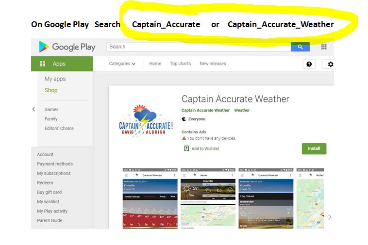 Be THANKFUL For the rest of November STUFFING 11/24, Sunday, early clouds to sun, highs around 50° GRANDPARENTS 11/25, Monday, sunshine, highs in the upper 50s to around 60° CASSEROLE 11/26, Tuesday, hazy sun & clouds, highs around 60° GRAVY 11/27, Wednesday, more clouds, showers, highs in the lower to mid-60s FAMILY 11/28, Thanksgiving, COLD MORNING (mid-30s), DRY TURKEY, partly sunny, highs in the lower to mid-50s SHOPPING, PUMPKIN PIE 11/29, Black Friday, showers, mainly north into Kentucky, partly sunny, highs in the upper 50s to lower 60s LEFTOVERS 11/30, Saturday, becoming mostly cloudy, rain late, highs in the mid-60s Thankful for you, East Tennessee #CaptAccurateWx  Expect around 1.0 to 1.50 + inches of rain areawide now through Saturday night with LOCALLY higher amounts. Tonight, cloudy with very little rain for much of the evening, but MORE rain by morning, mainly AFTER 3 AM, lows in the lower 50s. Normal low is 37° Saturday, overcast, rainy at times with downpours, isolated thunder, 100% chance of rain, highs around 60°. Normal high is 58° Saturday night, showers linger, 40% chance, with some fog, lows in the upper 30s to near 40°. Sunday, early clouds to sun, cooler, highs around 50°. Monday, sunshiny skies, highs in the upper 50s. Rainfall amounts now through Saturday night: Model A: 1.05" Model B: 1.53" Model C: 1.88" 3 model average: 1.486" of rain over a two day period Because accurate forecasts don't grow on trees #CaptAccurateWx  From NWS-Morristown Expect around 1.0 to 1.50 + inches of rain areawide today and Saturday with LOCALLY higher amounts. Rainfall Amounts, based on early morning models: Model A: 1.61" Model B: 1.93" Model C: 1.60" 3 Model Average: 1.713" When your forecast matters... #CaptAccurateWx Tonight, clouds thicken, showers develop, especially late, lows near 50. Normal low is 37° Friday, plenty of clouds, occasional showers, 60% chance, highs in the upper 50s Normal high is 58° Friday night, showers continue, lows in the lower 50s Saturday, cloudy, steady rain at times, 80% chance, highs in the lower 60s Rainfall amounts Friday into Saturday: Model A: 0.57" Model B: 0.95" Model C: 1.29" 3 model average: 0.936" of rain over a two day period When your forecast matters... #CaptAccurateWx  From NWS-Morristown Tennessee Volunteers (5-5) @ Missouri Tigers (5-5) Saturday, November 23rd Faurot Field at Memorial Stadium Columbia, MO Daytime highs in the lower to mid 40s Few rain showers early Saturday morning, otherwise, plenty of clouds 4:51 PM CST Sunset Televised on SEC Network 7:30 PM EST Kickoff,,,6:30 PM CST Decreasing clouds, cold Upper-30s for kickoff Lower to mid-30s by the end of the game W winds 5-10 mph #GoVols #GBO #CaptAccurateWx Credit: Ron Mulig for the cool artwork Tonight, some high clouds, chilly, lows in the mid to upper 30s Normal low is 38° Thursday, mix of sun & clouds, a warm breeze, spotty rain or sprinkles possible, 20% chance, highs in the lower to mid 60s Normal high is 59° Thursday night, more clouds, as showers roll in, especially late, lows near 50° Friday, plenty of clouds, periods of rain, 80% chance, highs in the upper 50s Rainfall amounts Friday into Saturday: Model A: 1.43" Model B: 1.12" Model C: 1.34 3 model average: 1.29" of rain over a two day period The value of a forecast is not just what you say, but when you say it #CaptAccurateWx Tonight, mostly cloudy, spotty rain or sprinkles, lows around 40° Normal low is 38° Track the light rain and sprinkles here on radar: Wednesday, morning clouds to afternoon sunshine, highs in the mid to upper 50s Normal high is 59° Wednesday night, some high clouds, lows in the mid to upper-30s Thursday, hazy sunshine, warmer, highs in the lower to mid-60s OUR BEST CHANCE OF RAIN THIS WEEK, AREAWIDE, ARRIVES FRIDAY AND INTO SATURDAY...NOVEMBER 22ND AND 23RD. It dries out nicely for Sunday It's not easy being Accurate #CaptAccurateWx  From NWS-Morristown Privacy Policy
Protecting your private information is our priority. This Statement of Privacy applies to CaptainAccurate.com and Captain Accurate Weather and governs data collection and usage. For the purposes of this Privacy Policy, unless otherwise noted, all references to Captain Accurate Weather include CaptainAccurate.com. By using the Captain Accurate Weather website, you consent to the data practices described in this statement. Collection of your Personal Information Captain Accurate Weather may collect anonymous demographic information, which is not unique to you. Please keep in mind that if you directly disclose personally identifiable information or personally sensitive data through Captain Accurate Weather's public message boards, this information may be collected and used by others. We do not collect any personal information about you unless you voluntarily provide it to us. However, you may be required to provide certain personal information to us when you elect to use certain products or services available on the Site. These may include: (a) registering for an account on our Site; (b) entering a sweepstakes or contest sponsored by us or one of our partners; (c) signing up for special offers from selected third parties; (d) sending us an email message; (e) submitting your credit card or other payment information when ordering and purchasing products and services on our Site. To wit, we will use your information for, but not limited to, communicating with you in relation to services and/or products you have requested from us. We also may gather additional personal or non-personal information in the future. Sharing Information with Third Parties Captain Accurate Weather does not sell, rent or lease its customer lists to third parties. Captain Accurate Weather may share data with trusted partners to help perform statistical analysis, send you email or postal mail, provide customer support, or arrange for deliveries. All such third parties are prohibited from using your personal information except to provide these services to Captain Accurate Weather, and they are required to maintain the confidentiality of your information. Captain Accurate Weather may disclose your personal information, without notice, if required to do so by law or in the good faith belief that such action is necessary to: (a) conform to the edicts of the law or comply with legal process served on Captain Accurate Weather or the site; (b) protect and defend the rights or property of Captain Accurate Weather; and/or (c) act under exigent circumstances to protect the personal safety of users of Captain Accurate Weather, or the public. Automatically Collected Information Information about your computer hardware and software may be automatically collected by Captain Accurate Weather. This information can include: your IP address, browser type, domain names, access times and referring website addresses. This information is used for the operation of the service, to maintain quality of the service, and to provide general statistics regarding use of the Captain Accurate Weather website. Links This website contains links to other sites. Please be aware that we are not responsible for the content or privacy practices of such other sites. We encourage our users to be aware when they leave our site and to read the privacy statements of any other site that collects personally identifiable information. Children Under Thirteen Captain Accurate Weather does not knowingly collect personally identifiable information from children under the age of thirteen. If you are under the age of thirteen, you must ask your parent or guardian for permission to use this website. Changes to this Statement Captain Accurate Weather reserves the right to change this Privacy Policy from time to time. We will notify you about significant changes in the way we treat personal information by sending a notice to the primary email address specified in your account, by placing a prominent notice on our site, and/or by updating any privacy information on this page. Your continued use of the Site and/or Services available through this Site after such modifications will constitute your: (a) acknowledgment of the modified Privacy Policy; and (b) agreement to abide and be bound by that Policy. Contact Information Captain Accurate Weather welcomes your questions or comments regarding this Statement of Privacy. If you believe that Captain Accurate Weather has not adhered to this Statement, please contact Captain Accurate Weather at: Captain Accurate Weather Knoxville, Tennessee Email Address: CaptainAccurate@davidaldrich.com Telephone number: 865-851-7182 Effective as of November 18, 2019 Tonight, increasing clouds, lows in the mid to upper 30s Normal low is 38° Tuesday, plenty of clouds, some hazy sun, spotty rain or sprinkles develop in the afternoon, 20% chance, highs in the lower to mid 50s Normal high is 59° Tuesday night, decreasing clouds, a touch of fog, lows in the upper-30s Wednesday, mostly sunny, highs in the mid to upper 50s OUR BEST CHANCE OF RAIN THIS WEEK, AREAWIDE, ARRIVES FRIDAY AND INTO SATURDAY...NOVEMBER 22ND AND 23RD. It dries out nicely for Sunday. The value of a forecast is not just what you say, but when you say it #CaptAccurateWx  Tonight, mostly cloudy, chilly, lows in the upper 30s to near 40° Normal low is 38° Monday, partly sunny, spotty rain or sprinkles possible, especially for the Smokies, 20% chance, highs in the lower to mid 50s Normal high is 59° Monday night, mostly cloudy, lows in the mid-30s Tuesday, mostly cloudy, spotty rain or sprinkles possible, 20% chance, highs in the upper 40s to lower 50s OUR BEST CHANCE OF RAIN THIS WEEK, AREAWIDE, ARRIVES FRIDAY, NOVEMBER 22ND. The value of a forecast is not just what you say, but when you say it #CaptAccurateWx  From NWS-Morristown Tonight, mostly clear, colder, near 32° Normal low is 39° Sunday, hazy sun, more high clouds, especially in the afternoon and evening, high in the mid to upper 50s. Sunday night, mostly cloudy, lows in the mid to upper 30s Monday, partly sunny, high around 50° MOST OF US WILL NOT SEE RAIN UNTIL FRIDAY, NOVEMBER 22ND. It's not easy being Accurate #CaptAccurateWx  From NWS-Morristown Tonight, mostly clear, a bit colder, near 30° Saturday, sunshiny skies, lower to mid-50s. Garth Brooks Concert, Saturday, November 16th, at Neyland Stadium, 7 PM Starry skies Around 40° at 7 PM Around 35° by 11 PM Dress warmly. Winds: VRB 0-5 mph Sunday, hazy sun, more high clouds, morning low around 30°, high in the mid-50s. MORE RAIN ARRIVES IN ABOUT A WEEK...AROUND FRIDAY, NOVEMBER 22ND. Because "The Thunder Rolls" - Garth Brooks #CaptAccurateWx  Tonight, partly to mostly cloudy, not as cold, a few sprinkles possible in the Smokies, lows in the upper 20s to lower 30s Friday, mix of clouds and sun, high in the upper 40s to lower 50s Saturday & Sunday, lower to mid-50s, bright sunshine both days with morning lows in the lower to mid-30s Garth Brooks Concert, Saturday, November 16th, at Neyland Stadium, 7 PM Starry skies Around 40° at 7 PM Around 35° by 11 PM Dress warmly. Winds: VRB 0-5 mph Because "The Thunder Rolls" - Garth Brooks #CaptAccurateWx  In case you missed this... A snow observation map from last Tuesday morning from NWS-Morristown. 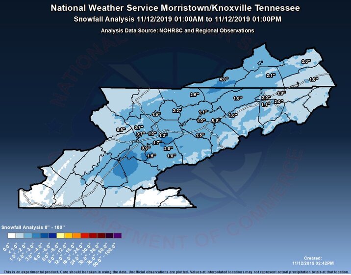 For those that like the extreme numbers for Knoxville, here they are, compliments of the NWS-Morristown. Could this happen? What about this? Has this ever happened before? See for yourself. And chances are, if you grew up here, you can check off numerous events below, where you can say: "I remember that. I lived it!" For more records from the National Weather Service in Morristown, click here. 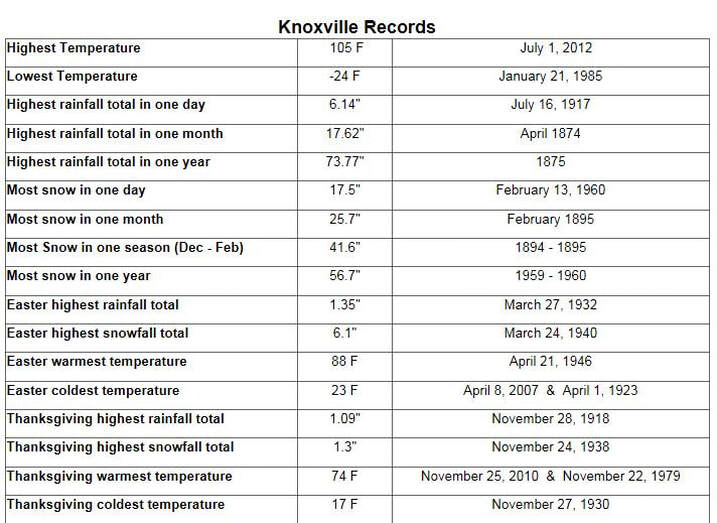 Now, let’s talk “White Christmas.” If you have seen my Winter Weather Outlook on the Home page of CaptainAccurate.com, you would already know where I stand on that idea for this year. Nothing has changed there in my view. But from a historical standpoint, Knoxville Records date back to the year 1871. Think about that. 1871 to 2018 represents 147 years of data. Obviously, I did not include December 2019 because it hasn’t happened yet. But out of 147 years, Knoxville has had measurable snow on 12 different occasions on Christmas Day. 12 Christmases / 147 years = 0.0816 So, from this data sample, Knoxville averages a “White Christmas” only 8% of the time. Not very high at all. And yet, thanks to the likes of Bing Crosby and others, the famous song gets played over and over and over again each holiday season. I once had a viewer in Rochester call me one time to complain when we were undergoing a warm spell in December. He said, “it’s not Christmas in upstate New York if it’s not white.” To which I said, “Yes, but I’m not sure it was snowing in Bethlehem when Christ was born.” Insert an awkward pause and then, he hung up on me. You can’t win all, now can you? :-) 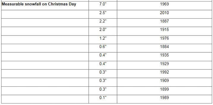 |
David AldrichCaptain Accurate Weather Archives
April 2024
Categories |
 RSS Feed