|
CAPTAIN ACCURATE'S WEATHER
BLOG |

|


|
Updated 11:20 AM Saturday Today: Mostly cloudy, 40% chance for rain showers, some mountain snowflakes, highs around 49° Saturday night: Mostly cloudy, showers fade, lows in the lower to mid 30s Groundhog Day / Super Bowl Sunday: Mostly sunny, warm breeze, gusts around 25 mph, highs in the mid to upper 50s Sunday night: Mostly clear, mild, lows around 40° Monday: Mostly sunny & warm, highs in the mid 60s Monday night: Increasing clouds, very mild, lows near 50° Tuesday: Cloudy, 60% chance for rain showers, highs around 60° For the latest 7 Day Forecast for your town or location, check out the Captain Accurate Weather App. I also have a BRAND NEW horizontal 7 Day Forecast for Knoxville and a BRAND NEW Video, posted daily, on the home page of CaptainAccurate.com and on the Captain Accurate Weather App. Check it out here. It's not easy being Accurate #CaptAccurateWx P.S. If you find these independent forecasts and posts helpful, please consider supporting me by downloading my NEW Captain Accurate Weather App. It's FREE. Just search: Captain Accurate at the App Store and Google Play. It comes with 5 FREE App Tutorials, so you can quickly learn all the wonderful things it can do.
1 Comment
Updated 8:45 AM Friday Today: Mostly cloudy, mild, spotty rain possible, 20% chance, highs in the lower to mid 50s Friday night: Overcast, few showers possible, 40% chance, lows around 40° Saturday: Mainly gray, 40% chance for rain showers, highs around 50° Saturday night: Mostly cloudy, showers fade, lows in the mid 30s Groundhog Day / Super Bowl Sunday: Becoming mostly sunny, highs in the mid 50s Sunday night: Partly cloudy, mild, lows around 40° Monday: Plenty of sun, scattered clouds, warm, highs in the mid 60s For the latest 7 Day Forecast for your town or location, check out the Captain Accurate Weather App. I also have a BRAND NEW horizontal 7 Day Forecast for Knoxville and a BRAND NEW Video, posted daily, on the home page of CaptainAccurate.com and on the Captain Accurate Weather App. Check it out here. It's not easy being Accurate #CaptAccurateWx P.S. If you find these independent forecasts and posts helpful, please consider supporting me by downloading my NEW Captain Accurate Weather App. It's FREE. Just search: Captain Accurate at the App Store and Google Play. It comes with 5 FREE App Tutorials, so you can quickly learn all the wonderful things it can do. 
Updated at 5:40 PM Thursday Tonight: Mostly cloudy, spotty rain, 20% chance, isolated snowflakes for the Smokies, and cold, lows in the mid 30s Thursday: Gray skies, becoming partly sunny, 20% chance for spotty rain, highs in the lower to mid 50s Thursday night: Mostly cloudy, lows in the upper 30s Friday: Mostly cloudy, milder, spotty rain possible, 20% chance, highs in the mid 50s Friday night: Clouds thicken, spotty rain, 20% chance, mild, lows near 40° Saturday: Cloudy skies with cold rain showers, 40% chance, mountain snowflakes, highs near 50. Saturday night: Mostly cloudy, showers linger, 40% chance, colder, lows in the lower 30s Superbowl Sunday / Groundhog Day: Partly cloudy, warmer, high in the lower to mid 50s For the latest 7 Day Forecast for your town or location, check out the Captain Accurate Weather App. I also have a BRAND NEW horizontal 7 Day Forecast for Knoxville and a BRAND NEW Video, posted daily, on the home page of CaptainAccurate.com and on the Captain Accurate Weather App. Check it out. It's not easy being Accurate #CaptAccurateWx P.S. If you find these independent forecasts and posts helpful, please consider downloading my NEW Captain Accurate Weather App. It's FREE. Just search: Captain Accurate at the App Store and Google Play. It comes with 5 FREE App Tutorials, so you can quickly learn all the wonderful things it can do.
Tuesday: Hazy sun & clouds, seasonably cold, highs in the upper 40s to near 50° Normal High for Knoxville: 48° Tuesday night: Mostly cloudy and cold, lows in the lower 30s Wednesday: Mainly gray. Spotty rain possible, 20% chance, highs in the mid 40s. Wednesday night: Mostly cloudy and cold, lows in the mid 30s Thursday: Partly sunny, 20% chance for spotty rain, highs in the upper 40s. Thursday night: Mostly cloudy, spotty rain possible, 20% chance, lows in the mid to upper 30s Friday: Mostly cloudy, milder, spotty rain possible, 20% chance, highs in the lower 50s For the latest 7 Day Forecast for your town or location, check out the Captain Accurate Weather App. I also have a BRAND NEW horizontal 7 Day Forecast for Knoxville and a BRAND NEW Video, posted daily, on the home page of CaptainAccurate.com and on the Captain Accurate Weather App. Check it out. It's not easy being Accurate #CaptAccurateWx P.S. If you find these independent forecasts and posts helpful, please consider downloading my NEW Captain Accurate Weather App. It's FREE. Just search: Captain Accurate at the App Store and Google Play. It comes with 5 FREE App Tutorials, so you can quickly learn all the wonderful things it can do.
Sunset 5:56 PM
Tonight: Gray skies. Showers increase, especially late, 60% chance, lows in the lower 40s Higher elevations in the Smokies above 4,000 feet may receive 2 + inches of snow. Normal Low for Knoxville: 29° Monday: Mostly cloudy with rain showers, steadiest rain falls in the morning. Higher elevations in the Smokies may continue to see some snow, total: up to 3" + expected. Highs in the upper 40s Normal High for Knoxville: 48° Monday night; Mostly cloudy and cold, lows in the lower 30s Tuesday: Partly sunny and dry, highs in the mid 40s Tuesday night: Mostly cloudy and cold, lows in the lower 30s Wednesday: Mainly gray. Spotty rain possible, 20% chance, highs in the mid 40s. Wednesday night: Mostly cloudy and colder, lows in the upper 20s Thursday: Sun through scattered clouds, highs in the upper 40s. For the latest 7 Day Forecast for your town or location, check out the Captain Accurate Weather App. I also have a BRAND NEW horizontal 7 Day Forecast for Knoxville and a BRAND NEW Video, posted daily, on the home page of CaptainAccurate.com and on the Captain Accurate Weather App. Check it out. It's not easy being Accurate #CaptAccurateWx P.S. If you find these independent forecasts and posts helpful, please consider downloading my NEW Captain Accurate Weather App. It's FREE. Just search: Captain Accurate at the App Store and Google Play. It comes with 5 FREE App Tutorials, so you can quickly learn all the wonderful things it can do. Sunset 5:56 PM Tonight: Mostly cloudy, lows in the lower 30s Normal Low for Knoxville: 29° Sunday: Mix of clouds and sun, highs near 50° Normal High for Knoxville: 48° Sunday night: Gray skies. Spotty rain develops, 20% chance, lows in the lower 40s Monday: Mostly cloudy with a 40% chance of rain showers, mainly in the morning. Higher elevations in the Smokies may see a rain and snow combination. Highs near 50° Monday night; Mostly cloudy, lows in the mid 30s Tuesday: Becoming partly cloudy. highs near 50° Tuesday night: Mostly cloudy and dry, lows in the mid 30s Wednesday: Mostly cloudy. Spotty rain possible, 20% chance, highs in the mid 40s. For the latest 7 Day Forecast for your town or location, check out the Captain Accurate Weather App. I also have a BRAND NEW horizontal 7 Day Forecast for Knoxville and a BRAND NEW Video, posted daily, on the home page of CaptainAccurate.com and on the Captain Accurate Weather App. Check it out. It's not easy being Accurate #CaptAccurateWx P.S. If you find these independent forecasts and posts helpful, please consider downloading my NEW Captain Accurate Weather App. It's FREE. Just search: Captain Accurate at the App Store and Google Play. It comes with 5 FREE App Tutorials, so you can quickly learn all the wonderful things it can do.
UPDATED 4:09 PM Friday Tonight: Turning colder, rain showers fade for most, some mixing with flurries possible, especially in the Smokies and in higher elevations, lows in the mid-30s. Saturday: Mostly cloudy. Spots of drizzle and flurries possible, especially for the Smokies, Plateau and higher elevations, highs in the lower to mid 40s Saturday night; Mostly cloudy, colder, lows near 30° Sunday: Mix of clouds and sun, spotty rain later at night, 20% chance, highs in the upper 40s For the latest 7 Day Forecast for your town or location, check out the Captain Accurate Weather App. I also have a BRAND NEW horizontal 7 Day Forecast for Knoxville and a BRAND NEW Video, posted daily, on the home page of CaptainAccurate.com and on the Captain Accurate Weather App. Check it out. It's not easy being Accurate #CaptAccurateWx P.S. If you find these independent forecasts and posts helpful, please consider downloading my NEW Captain Accurate Weather App. It's FREE. Just search: Captain Accurate at the App Store and Google Play. It comes with 5 FREE App Tutorials, so you can quickly learn all the wonderful things it can do.
Last time Knoxville fell into the teens (19°) was November 13th, 2019...more than 2 months ago. Last time Knoxville fell into the middle teens (14°) was January 21st, 2019...a year ago. FYI This morning and yesterday morning, Knoxville fell to 24° for the low temperature. Tonight: Starry skies, very cold, lows in the upper teens. Wind chill in the lower teens to around 10° above NNE winds 3 - 8 + mph Wednesday: Mostly sunny with increasing high clouds in the afternoon, highs in the mid-40s Wednesday night: Mostly cloudy, cold, lows near 30° Thursday: Mostly cloudy, spotty rain late, 20% chance, highs in the upper 40s Thursday night: Showers increase, 40% chance, lows in the upper 30s Friday: Periods of rain, 80% chance, highs around 50° ***I am expecting around 0.50" to 1.00" of rain for East Tennessee on average on Friday.*** For the latest 7 Day Forecast for your town or location, check out the Captain Accurate Weather App. I also have a BRAND NEW horizontal 7 Day Forecast for Knoxville and a BRAND NEW Video, posted daily, on the Captain Accurate Weather App. Check it out. It's not easy being Accurate #CaptAccurateWx P.S. If you find these independent forecasts and posts helpful, please consider downloading my NEW Captain Accurate Weather App. It's FREE. Just search: Captain Accurate at the App Store and Google Play. It comes with 5 FREE App Tutorials, so you can quickly learn all the wonderful things it can do.
Today's headline:
Clouds slow to budge and flakes quick to fly. How many of you saw some snowflakes today? Flurries and snow showers appeared under clouds that were slow to move under a north - northeast flow of air. Hit LOOP after clicking this link: https://bcaws.aviationweather.gov/satellite/plot?region=mgm&type=vis In fact, the sunny breaks were more common today in central Kentucky than they were in East Tennessee, as moisture pooled down from Middlesboro and the Tri-Cities. Expect another cold night tonight: More clouds, especially high clouds, cold, low in the lower 20s Tuesday: Early clouds and flurries, becoming mostly sunny, highs in the mid-30s Tuesday night: Starry skies, cold, lows in the lower 20s Wednesday: Mostly sunny with increasing high clouds in the afternoon, highs in the mid-40s Wednesday night: Mostly cloudy, cold, lows near 30° Thursday: Mostly cloudy, highs in the lower 50s For the latest 7 Day Forecast for your town or location, check out the Captain Accurate Weather App. It's not easy being Accurate #CaptAccurateWx P.S. If you find these independent forecasts and posts helpful, please consider downloading my NEW Captain Accurate Weather App. It's FREE. Just search: Captain Accurate at the App Store and Google Play. It comes with 5 FREE App Tutorials, so you can quickly learn all the wonderful things it can do. Tonight: Mostly clear, bitter cold, lows in the upper teens to around 20° Wind chill: 8° to 13° Martin Luther King, Jr. Day: Cold, early flurries possible, becoming mostly sunny, highs in the lower 30s Monday night: A few high clouds, lows in the lower 20s Tuesday: Mostly sunny, still cold, highs in the mid 30s Tuesday night: Starry skies, very cold, low near 20° Wednesday: Mostly sunny, a bit milder, high in the mid 40s For the latest 7 Day Forecast for your town or location, check out the Captain Accurate Weather App. It's not easy being Accurate #CaptAccurateWx P.S. If you find these independent forecasts and posts helpful, please consider downloading my NEW Captain Accurate Weather App. It's FREE. Just search: Captain Accurate at the App Store and Google Play. It comes with 5 FREE App Tutorials, so you can quickly learn all the wonderful things it can do.
Who's READY for the Weekend ? Well, Tonight: Cloudy skies, spotty rain by morning, lows in the upper 30s to around 40° BEST CHANCE FOR RAIN THIS WEEKEND: 10 AM to 9 PM Saturday (Knoxville / Valley Times) It's the best chance, not the only chance. I suspect the rain will arrive about 2 hours faster for the Plateau and linger about 2 hours later for the Smokies. Saturday: Gray skies, scattered rain showers, 80% chance, breezy, gusts around 25 mph, but higher on hilltops, highs in the lower 50s A quarter to a third of an inch of rain is expected, on average. Saturday night; Plenty of clouds, evening rain showers will fade, but could end as some snow flurries or a mix, mainly for the Smokies, lows around 30° Sunday: Mostly sunny, colder, highs around 40° Sunday night: Mostly clear and colder, lows around 20° Martin Luther King, Jr. Day: Bright sun, few scattered clouds, still cold, highs in the mid-30s. Normal HIGHS & LOWS this weekend: 47° and 29° For my latest 7 Day Forecast, check out the Captain Accurate Weather App. It's not easy being Accurate #CaptAccurateWx P.S. If you find these independent forecasts and posts helpful, please consider downloading my NEW Captain Accurate Weather App. It's FREE. Just search: Captain Accurate at the App Store and Google Play. It comes with 5 FREE App Tutorials, so you can quickly learn all the wonderful things it can do.
The amount of rain that falls this Saturday varies for Knoxville and East Tennessee: Model A: 0.14" Model B: 0.16" Model C: 0.31" 3 Model Average: 0.203" Naturally, some locally higher amounts can be expected. No thunder, just rain. But do expect mainly gray skies on Saturday with morning lows in the upper 30s to around 40° and highs in the lower 50s. It will be breezy on Saturday as well with gusts around 25 mph. For my latest 7 Day Forecast, check out the Captain Accurate Weather App. So weather does not surprise you #CaptAccurateWx P.S. If you find these independent forecasts and posts helpful, please consider downloading my NEW Captain Accurate Weather App. It's FREE. Just search: Captain Accurate at the App Store and Google Play. It comes with 5 FREE App Tutorials, so you can quickly learn all the wonderful things it can do.  It's FREE. Just search: Captain Accurate at the App Store and Google Play.  Sunrise: 7:45 AM Today: Becoming mostly sunny, daytime highs in the mid-50s Normal High this week: 47° Sunset 5:46 PM Tonight: Some high clouds, colder, lows in the upper 20s to around 30° Normal Low this week: 29° Friday: From hazy sun to more clouds in the afternoon, highs in the upper 40s Friday night: Clouds thicken, spotty rain late, 20% chance, lows in the upper 30s Saturday: Gray skies, scattered rain showers, 60% chance, breezy, gusts around 25 mph, but higher on hilltops, highs in the lower 50s Saturday night; Plenty of clouds, rain showers fade, could end as some snow flurries or a mix, mainly for the Smokies, lows around 30° Sunday: Mostly sunny, colder, highs in the lower 40s For my latest 7 Day Forecast, check out the Captain Accurate Weather App. It's not easy being Accurate #CaptAccurateWx P.S. If you find these independent forecasts and posts helpful, please consider downloading my NEW Captain Accurate Weather App. It's FREE. Just search: Captain Accurate at the App Store and Google Play. It comes with 5 FREE App Tutorials, so you can quickly learn all the wonderful things it can do.  It's FREE. Just search: Captain Accurate at the App Store and Google Play.  Additional Rainfall to Expect, based on data from Wednesday morning Model A: 0.26" Model B: 0.16" Model C: 0.52" 3 Model Average: 0.313" Naturally, you can expect some locally higher amounts. Wednesday: Morning fog, mostly cloudy, some hazy sun, scattered showers and storms, 60% chance, some could be strong to severe, particularly in the afternoon and evening. Hail and damaging wind may result. Look for highs in the upper 60s to near 70°. Record high is 72° from 1907, back when Theodore Roosevelt was President. Wednesday night:. More showers and storms, 60% chance, cooler, lows in the mid to upper 40s. Thursday: Becoming mostly sunny. Lower to mid 60s after midnight, daytime highs in the lower to mid 50s. An "Upside down" day For my latest 7 Day Forecast, check out the Captain Accurate Weather App. So weather does not surprise you #CaptAccurateWx A MARGINAL (or isolated) risk for severe storms is in effect for East Tennessee on Wednesday from the Storm Prediction Center https://www.spc.noaa.gov/products/outlook/day2otlk.html P.S. If you find these independent forecasts and posts helpful, please consider downloading my NEW Captain Accurate Weather App. It's FREE. Just search: Captain Accurate at the App Store and Google Play. It comes with 5 FREE App Tutorials, so you can quickly learn all the wonderful things it can do.. 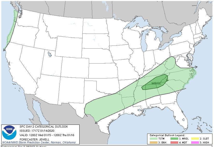
Expect showers and storms between now and early Thursday morning. FUTURE RAINFALL data, as of Tuesday morning...now coming closer together. Model A: 1.02" Model B: 1.29" Model C: 1.09" 3 Model Average for East Tennessee: 1.14" Naturally, you can expect some locally higher amounts. For my latest 7 Day Forecast, check out the Captain Accurate Weather App. So weather does not surprise you #CaptAccurateWx P.S. If you find these independent forecasts and posts helpful, please consider downloading my NEW Captain Accurate Weather App. It's FREE. Just search: Captain Accurate at the App Store and Google Play. It comes with 5 FREE App Tutorials, so you can quickly learn all the wonderful things it can do.  It's FREE. Just search: Captain Accurate at the App Store and Google Play.  Tonight: Increasing clouds, few showers possible by morning, 20% chance, lows in the mid to upper 40s and RISING Normal Low this week: 29° Sunrise: 7:46 AM Monday: Stray showers, 20% chance, plenty of clouds, some hazy sun, warm, highs in the mid 60s Normal High this week: 47° Sunset 5:43 PM Monday night: Showers increase with thunder, 60% chance, warm, lows in the mid 50s Tuesday: Periods of rain and thunder, heavy at times, 100% chance, warmer, highs in the upper 60s ***SOME OF THE STORMS TUESDAY into WEDNESDAY could be STRONG to SEVERE.*** Wednesday: Cloudy, showers and thunderstorms, 80% chance, warm, highs in the upper 60s Wednesday night: Showers and storms, 80% chance, lows in the mid 50s Thursday: Morning showers possible, 40% chance, clouds to sunshine, highs in the lower 60s after midnight, daytime highs in the lower 50s. An "Upside Down" day. Thursday night: Partly cloudy, lows in the lower to mid 30s Friday: Partly cloudy. Spotty rain possible at night, highs in lower 50s. Today's model runs for rain this week suggests that East Tennessee from Monday to Thursday morning will receive: Model A...2.36" Model B...0.82" Model C...2.27" 3 Model Average: 1.816" of potential rainfall, spread out over 3 + days Expect LOCALLY HIGHER amounts. So the weather does not surprise you #CaptAccurateWx HINT: It will turn MUCH COLDER NEXT WEEK !!! P.S. If you find these independent forecasts and posts helpful, please consider downloading my NEW Captain Accurate Weather App. It's FREE. Just search: Captain Accurate at the App Store and Google Play. It comes with 5 FREE App Tutorials, so you can quickly learn all the wonderful things it can do.  It's FREE. Just search: Captain Accurate at the App Store and Google Play.  Saturday: STRONGEST WINDS, and potentially DAMAGING, for the Valley: 10 AM to 4 PM BEST CHANCE FOR RAIN: 3 PM to 10 PM Mostly cloudy, some hazy sun, windy Showers and thunder developing, heavier toward evening Record breaking heat with highs in the mid 70s. ( and with enough wind, upper 70s ) Knoxville's Record high on Saturday will likely fall: 72° (1890) Damaging wind possible Saturday Gusts in the Valley & Plateau: over 50 to 60 + mph potentially. Gusts in the Smokies: over 70 to 80 + mph potentially. Cannot rule out an isolated tornado somewhere in East Tennessee. Keep in mind, damaging straight-line winds are more likely to occur, which could still cause significant property damage. Today's model runs for rain suggest: Model A...0.65" Model B...0.95" Model C...0.66" 3 Model Average: 0.75" of potential rain late Friday into Saturday. Saturday night: Evening downpours, breezy, lows in the upper 40s Sunday: Becoming mostly sunny, highs in the lower 60s Monday: More clouds, hazy sun, few showers, highs in the lower 60s So weather does not surprise you #CaptAccurateWx P.S. If you find these independent forecasts and posts helpful, please consider downloading my NEW Captain Accurate Weather App. It's FREE. Just search: Captain Accurate at the App Store and Google Play. It comes with 5 FREE App Tutorials, so you can quickly learn all the wonderful things it can do.  It's FREE. Just search: Captain Accurate at the App Store and Google Play.  Friday: Plenty of clouds, some hazy sun, warm, some drizzle possible, highs in the mid 60s Friday night: Mostly cloudy, stray showers possible, warm, lows in the mid 50s Saturday: Mostly cloudy, some hazy sun, wind-driven showers, heavier toward evening, BEST chance for rain: 3 PM to 10 PM, isolated thunder, record breaking heat with highs in the lower to mid 70s. Knoxville's Record high on Saturday is in play: 72° (1890)...130 year old record ! Last time Knoxville was that warm on the 11th of January was when Benjamin Harrison was in the White House. Damaging wind possible Saturday Gusts in the Valley & Plateau: over 50 mph potentially. Gusts in the Smokies: over 70 + mph potentially. Cannot rule out an isolated tornado somewhere in East Tennessee. Today's model runs for rain suggest: Model A...0.55" Model B...0.78" Model C...0.75" 3 Model Average: 0.69" of potential rain late Friday into Saturday. Sunday: Mostly sunny, highs around 60° Monday: Partly cloudy, highs in the lower 60s So the weather does not surprise you #CaptAccurateWx P.S. If you find these independent forecasts and posts helpful, please consider downloading my NEW Captain Accurate Weather App. It's FREE. Just search: Captain Accurate at the App Store and Google Play. It comes with 5 FREE App Tutorials, so you can quickly learn all the wonderful things it can do.
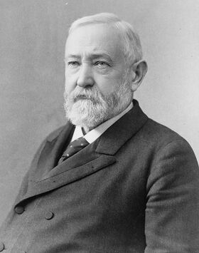
Friday: Hazy sun & clouds, spotty rain late, warm, highs in the mid to upper 60s Saturday: Mostly cloudy, wind-driven showers, turning heavier toward evening, isolated thunder, very warm, gusts in the Valley: over 50 mph potentially. Gusts in the Smokies: over 70 + mph potentially. Knoxville's Record high on Saturday is in play: 72° (1890)...back when Benjamin Harrison was in the White House...130 years ago!! Expect a Knoxville high around 73° Today's model runs suggest LESS RAIN for us and MORE RAIN for West and Middle Tennessee. East Tennessee Model A...1.05" Model B...0.84" Model C...0.37" 3 Model Average: 0.753" of potential rain late Friday into Saturday. Drying out nicely for Sunday with bright sunshine and highs in the lower to mid-60s. So the weather does not surprise you #CaptAccurateWx P.S. If you find these independent forecasts and posts helpful, please consider downloading my NEW Captain Accurate Weather App. It's FREE. Just search: Captain Accurate at the App Store and Google Play. It comes with 5 FREE App Tutorials, so you can quickly learn all the wonderful things it can do.
|
David AldrichCaptain Accurate Weather Archives
April 2024
Categories |


 RSS Feed