|
CAPTAIN ACCURATE'S WEATHER
BLOG |

|


|
Rain develops on Thursday...turning moderate to heavy. Periods of heavy rain Friday. Heavier rain Friday night with downpours, potentially. Localized flooding could be an issue. Rainfall amounts from Thursday to Saturday: 1-3"+ with locally higher amounts Mostly cloudy Saturday, rain showers that could end as snow showers by Saturday evening. Snow Trend: 0.5" or less of snow may fall, but even less may stick. Higher amounts for the Smokies, of course. ---signed Captain Accurate P.S. If you find these independent forecasts and posts helpful, please consider downloading my NEW Captain Accurate Weather App. It's FREE. Just search: Captain Accurate at the App Store and Google Play. It comes with 5 FREE App Tutorials, so you can quickly learn all the wonderful things it can do.  It's FREE. Just search: Captain Accurate at the App Store and Google Play. 
0 Comments
Bye Bye 2019 Tonight we RING in a NEW YEAR: 2020 !!! Are you READY? Today: Sunrise 7:46 AM Partly to mostly cloudy, breezy, gusts 25 to 30 mph, seasonably cold, highs the mid to upper 40s Sunset 5:32 PM New Year's Eve Night: Few scattered clouds, colder, mid to upper 30s at the stroke of midnight, frost possible by sunrise, overnight lows in the lower 30s. New Year's Day: Mostly sunny, less wind, highs in the upper 40s to near 50° Wednesday night: Increasing clouds, lows in the mid 30s Thursday: Cloudy skies, turning rainy, 80% chance, highs around 50° Thursday night: More rain, 80% chance, lows in the mid 40s and RISING Friday: Periods of rain, 80% chance, highs in the lower 60s Saturday: Mostly cloudy, rain showers, 40% chance, early high in the lower 50s and FALLING into the 40s Sunday: Mix of sun & clouds, chilly, highs in the mid 40s It's not easy being Accurate #CaptAccurateWx P.S. If you find these independent forecasts and posts helpful, please consider downloading my NEW Captain Accurate Weather App. It's FREE. Just search: Captain Accurate at the App Store and Google Play. It comes with 5 FREE App Tutorials, so you can quickly learn all the wonderful things it can do.   It's FREE. Just search: Captain Accurate at the App Store & Google Play.  Just so you know... At the end of last year, it was announced by the National Weather Service in Morristown that 2018 was the 8th Wettest year on record for Knoxville, dating back to 1871, when records for Knoxville began. The next day or so, TVA made the bold announcement that 2018 was, in fact, the Wettest year ever for much of East Tennessee (and they were including in that assessment the soggy year for Mt. Mitchell in North Carolina as part of their summary). For headline seekers, I'll let you guess which one was circulated the most. You guessed it: "Wettest Year Ever." But if you look, like I do, a little closer at the numbers, you would quickly realize that TVA did not begin until May 13th, 1933. At the time, FOUR of the TOP 8 Wettest Years were in the 1880s, which would have been outside the purview of the TVA. Thus, both headlines were correct. But it may have been more honest to circulate and say, 2018 was the Wettest year ever since 1933, according to TVA records. You see, the National Weather Service in Morristown has 147 years of Knoxville records, dating back to 1871. The Tennessee Valley Authority (TVA), founded by FDR and George W. Norris, has 85 years of records (since 1933). Hard to compare apples with oranges sometimes, don't you think? Average Yearly Rainfall for Knoxville: 47.86" (1981-2010) Highest rainfall total in one day: 6.14"...July 16, 1917 Highest rainfall total in one month: 17.62"...April 1874 TOP 10 WETTEST YEARS on Record for Knoxville, since 1871. 1). 73.77"...1875 2). 69.35"...2013 3). 66.36"...1882 4). 64.29”…2019 <----Here we are. 5). 63.27"...1994 6). 62.53"...1884 7). 61.49"...1957 8). 61.45"...1886 9). 61.37"...2018 10). 60.66”...2009 Credit: NWS-Morristown Of course, looking back at this year, February 2019 certainly TIPPED THE SCALES with over 13 inches of rain, SOGGIEST February on record, during the shortest month of the year. In September 2019, the weather pendulum swung the other way with drought-like conditions and Knoxville only received 0.03" of rain...giving us the DRIEST September on record. It's kinda like going to the beach. February was HIGH tide, September was LOW tide. Sometimes that's how Nature works. Knoxville's Rain (and Melted Snow) in 2019 @ McGhee Tyson Airport Jan. 4.98"..................................normal 4.32" Feb. 13.08".................................normal 4.26" Mar. 4.05".................................normal 4.34" Apr. 4.39"..................................normal 4.01" May 5.70"..................................normal 4.51" Jun. 7.02"...................................normal 3.81" Jul. 5.88"....................................normal 5.08" Aug. 3.13"...................................normal 3.27" Sep. 0.03"..................................normal 3.24" Oct. 4.96"...................................normal 2.51" Nov. 6.11"...................................normal 4.01" Dec. 4.96"..................................normal 4.50" TOTAL: 64.29"..............normal 47.86" #CaptAccurateWx P.S. If you find these independent forecasts and posts helpful, please consider downloading my NEW Captain Accurate Weather App. It's FREE. Just search: Captain Accurate at the App Store and Google Play. It comes with 5 FREE App Tutorials, so you can quickly learn all the wonderful things it can do.  It's FREE. Just search: Captain Accurate at the App Store and Google Play.  Knoxville was at 72° at 1 AM Monday. Expect an "Upside Down Day", thanks to the passage of a cold front with FALLING temperatures. Sunrise 7:46 AM Today: Plenty of sun, scattered clouds, breezy, gusts around 25 mph, daytime highs the lower to mid 50s Sunset 5:31 PM Tonight: Few scattered clouds, colder, lows in the mid 30s. Tuesday: Partly cloudy, seasonably cold, breezy, gusts 25-30 mph, high in the mid to upper 40s New Years Eve Night: Few scattered clouds, 12 AM temperatures in the mid to upper 30s...around 37° for Knoxville at the stroke of midnight. Overnight lows in the lower 30s and frosty by morning. New Year's Day: Mostly sunny, less wind, highs in the upper 40s to near 50° Wednesday night: More clouds, lows in the upper 30s Thursday: Cloudy skies, turning rainy, 80% chance, highs around 50° P.S. Plan on a rainy Thursday evening for Knoxville and local East Tennessee TaxSlayer Gator Bowl parties. I wrote about this on CaptainAccurate.com last Saturday. Thursday night: More rain, 80% chance, lows in the mid 40s and RISING Friday: Periods of rain, 80% chance, highs in the lower 60s The value of a forecast is not just what you say, but when you say it #CaptAccurateWx Check out this other UPDATED blog: Knoxville's Record Highs & Lows of 2019, click here P.S. If you find these independent forecasts and posts helpful, please consider downloading my NEW Captain Accurate Weather App. It's FREE. Just search: Captain Accurate at the App Store and Google Play. It comes with 5 FREE App Tutorials, so you can quickly learn all the wonderful things it can do.  Happy New Year, East Tennessee! Here's to a better and brighter New Year! It's FREE. Just search: Captain Accurate at the App Store and Google Play.  TaxSlayer Gator Bowl, 75th Game Indiana Hoosiers (8-4) @ Tennessee Volunteers (7-5) Thursday, January 2, 2020 TIAA Bank Field Jacksonville, FL Televised on ESPN Around 70° for highs during the day, partly cloudy & dry 5:38 PM Sunset 7 PM Kickoff mid to upper 60s for kickoff lower to mid 60s for the balance of the game S winds 5-10 mph #GoVols #GBO #CaptAccurateWx P.S. Plan on a rainy Thursday evening for Knoxville and local East Tennessee parties. Credit: Ron Mulig for the cool artwork 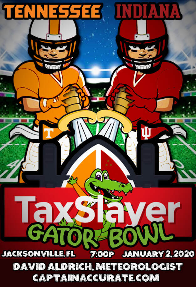 Knoxville 2019 13 Record Highs 2 Record Lows WETTEST February on record since 1871: 13.08" Normal February rainfall and melted snow: 4.26" DRIEST September on record since 1871: 0.03" Normal September rainfall: 3.24" January None February...1 Record high 77° Record high...2/7/2019 March None April None May None June None July...1 Record low 57° Record low...7/24/2019 August None September...7 Record highs 97° Record high...9/10/2019 94° Record high...9/12/2019 97° Record high...9/13/2019 89° Record high...9/26/2019 92° Record high...9/27/2019 95° Record high...9/29/2019 95° Record high...9/30/2019 October...3 Record highs 95° Record high...10/1/2019 96° Record high...10/2/2019 96° Record high...10/3/2019 November...1 Record low 20° Record low...11/12/2019 December...2 Record highs 73° Record high...12/16/2019 78° Record high...12/29/2019....UPDATED, this broke the old record high by 7°! It's not easy being Accurate #CaptAccurateWx P.S. If you find these independent forecasts and posts helpful, please consider downloading my NEW Captain Accurate Weather App. It's FREE. Just search: Captain Accurate at the App Store and Google Play. It comes with 5 FREE App Tutorials, so you can quickly learn all the wonderful things it can do. It's FREE! Just search: Captain Accurate at the App Store and Google Play.   From NWS-Morristown Tonight: Mostly cloudy, lows in the lower to mid-40s Sunrise 7:45 AM Saturday: Hazy sun & clouds, warm, highs in the upper 60s. Saturday's Record high: 76° (2015) Sunset 5:30 PM Saturday night: Cloudy skies, drizzle possible, lows in the lower to mid-50s Sunday: Warm, mainly gray, rain showers develop, spotty at first, 60% chance of rain, highs in the upper 60s to lower 70s with NEW Record warmth expected for Knoxville. Sunday's Record high: 71° (1954) HEAVIEST RAIN occurs Sunday night with isolated thunderstorms...80% chance How much RAIN? Model A...0.86" Model B...1.08" Model C...0.65" 3 model average: 0.863" When your forecast matters... #CaptAccurateWx P.S. If you find these independent forecasts helpful, please consider downloading my NEW Captain Accurate Weather App. It's FREE. Just search: Captain Accurate at the App Store and Google Play. It comes with 5 FREE App Tutorials, so you can quickly learn all the wonderful things it can do. It's FREE! Just search: Captain Accurate at the App Store and Google Play.   Tonight: Increasing clouds, lows in the lower to mid-40s. Sunrise 7:45 AM Friday: Mostly cloudy, some hazy sun, spotty rain possible, especially for the Plateau, 20% chance, highs in the lower-60s. Sunset 5:29 PM Friday night: More clouds, lows in the mid-40s Saturday: Hazy sun & clouds, warm, highs in the upper 60s. Record high: 76° (2015) Saturday night: Cloudy skies, lows in the lower to mid-50s Sunday: Cloudy skies, rain showers develop, spotty at first, 80% chance of rain, highs in the upper 60s. Record high: 71° (1954) HEAVIEST RAIN occurs Sunday night. How much RAIN for Sunday? Model A...1.56" Model B...1.18" 2 model average: 1.37" When your forecast matters... #CaptAccurateWx P.S. If you find these independent forecasts helpful, please consider downloading my NEW Captain Accurate Weather App. It's FREE. Just search: Captain Accurate at the App Store and Google Play. It comes with 5 FREE App Tutorials, so you can quickly learn all the wonderful things it can do. It's FREE! Just search: Captain Accurate at the App Store and Google Play.  Starting Thursday morning around 40° with patchy fog. Sunrise 7:44 AM Today: Some patchy fog early, otherwise, mostly sunny, highs in the mid-60s. Sunset 5:29 PM Tonight: Increasing clouds, lows in the mid-40s. Friday: Mostly cloudy, spotty rain for the Plateau, 20% chance, highs in the lower-60s. Friday night: More clouds, lows in the mid-40s Saturday: Mix of clouds and sun, highs in the mid to upper 60s. Saturday night: Cloudy skies, lows in the lower to mid-50s Sunday: Cloudy skies, rain showers develop, mostly in the late morning into the afternoon, 80% chance of rain, highs in the mid-60s. When your forecast matters... #CaptAccurateWx It's FREE! Just search: Captain Accurate at the App Store and Google Play. 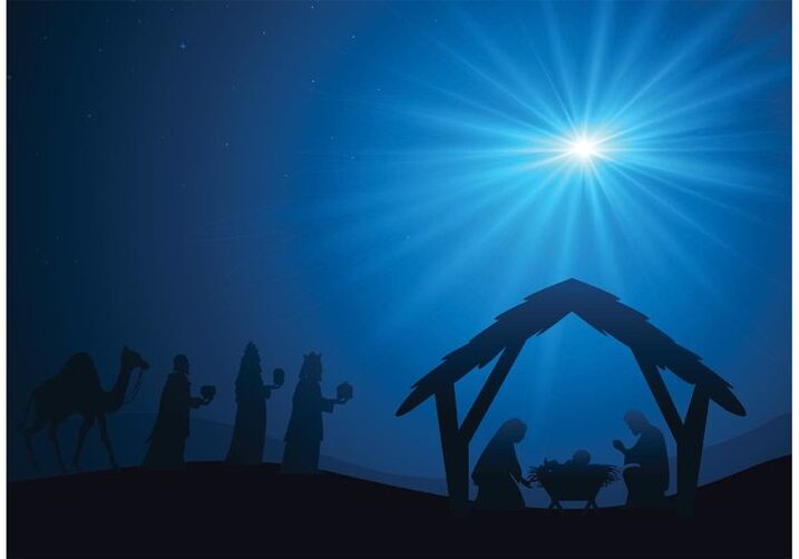 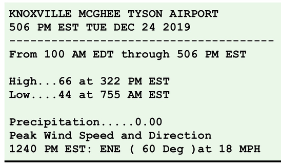 From NWS-Morristown Christmas Eve night: Scattered clouds, more patchy fog, lows near 40° to lower 40s. Christmas Day: Some early fog, becoming mostly sunny, unseasonably warm, highs in the mid-60s Normal high for Christmas: 48° Record high for Christmas: 76° (1982) Wednesday night: Partly cloudy, patchy fog, lows near 40° Thursday: Mostly sunny, highs in the mid-60s Thursday night: Increasing clouds, lows in the mid-40s Friday: Mix of sun & clouds, highs near 60° This warm Christmas outlook was first presented on November 5th during my Winter Weather Outlook. To see that video for the rest of this upcoming winter, go to the Home page of CaptainAccurate.com, scroll down a bit, then hit PLAY. The value of a forecast is not just what you say, but when you say it #CaptAccurateWx P.S. If you find these independent forecasts helpful, please consider downloading my NEW Captain Accurate Weather App. It's FREE. Just search: Captain Accurate at the App Store and Google Play. It comes with 5 FREE App Tutorials, so you can quickly learn all the wonderful things it can do. And Merry Christmas! It's FREE. Just search: Captain Accurate at the App Store and Google Play 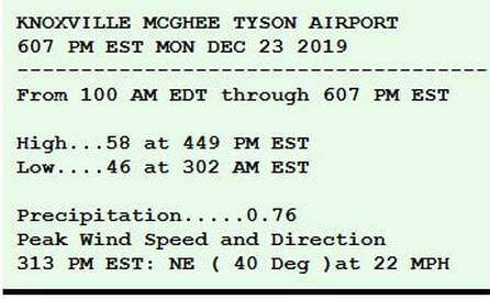 Even with today's rain, it was unseasonably warm. Normal high: 48° The closest thing we get to a White Christmas this year is morning fog. I think that's how Rudolph the Red Nose Reindeer got started, isn't it? ;-) Tonight: Scattered clouds, patchy fog late, lows in the lower to mid-40s. Sunrise 7:43 AM Christmas Eve: Patchy fog to sunshiny skies, highs in the lower to mid-60s. Sunset 5:27 PM Christmas Eve night: Scattered clouds, more patchy fog, lows in the lower to mid-40s. Christmas Day: Some early fog, becoming mostly sunny, unseasonably warm, highs in the mid-60s Normal high for Christmas: 48° Record high for Christmas: 76 (1982) This warm Christmas outlook was first presented on November 5th during my Winter Weather Outlook. To see that video for the rest of this upcoming winter, go to the Home page of CaptainAccurate.com, scroll down a bit, then hit PLAY. The value of a forecast is not just what you say, but when you say it #CaptAccurateWx P.S. If you find these independent forecasts helpful, please consider downloading my NEW Captain Accurate Weather App. It's FREE. Just search: Captain Accurate at the App Store and Google Play. It comes with 5 FREE App Tutorials, so you can quickly learn all the wonderful things it can do. And Merry Christmas! It's FREE. Just search: Captain Accurate at the App Store and Google Play. Sunday's low in Knoxville was 41°. Sunday's high in Knoxville was 46°. Periods of rain continues tonight. Latest models still suggest one inch of rain on average across Knoxville and East Tennessee, with locally higher amounts, from now until the time we reach midday Monday. Model A: 0.91" Model B: 1.02" Model C: 1.10" 3 Model Average: 1.01" Here's your latest forecast that includes Christmas... Tonight: Periods of rain, 80% chance, lows in the mid 40s and rising. Sunrise 7:43 AM Monday: Rain showers, 60% chance, mostly in the A.M., otherwise, mostly cloudy, highs in the mid to upper 50s Sunset 5:27 PM Monday night: Scattered clouds, lows in the lower 40s. Christmas Eve: Patchy fog to sunshiny skies, highs in the mid-60s. Christmas Eve night: Scattered clouds, patchy fog, lows in the lower to mid-40s. Christmas Day: Some early fog, becoming mostly sunny, unseasonably warm, highs in the mid-60s Normal high for Christmas: 48° Record high for Christmas: 76 (1982) This warm Christmas outlook was first presented on November 5th during my Winter Weather Outlook. To see that video for the rest of this upcoming winter, go to the Home page of CaptainAccurate.com, scroll down a bit, then hit PLAY. It's not easy being Accurate #CaptAccurateWx P.S. If you find these independent forecasts helpful, please consider downloading my NEW Captain Accurate Weather App. It's FREE. Just search: Captain Accurate at the App Store and Google Play. It comes with 5 FREE App Tutorials, so you can quickly learn all the wonderful things it can do. And Merry Christmas! It's FREE. Just search: Captain Accurate on the App Store and Google Play. Rain is coming. And it should be heaviest Sunday night into early Monday morning. Got plans? Be sure to grab the umbrella. Here's a look at the FUTURE rainfall for Knoxville and East Tennessee, based on 3 of the more popular models (psst! I look at many others, too, but this is a good representation.) Winds will be slowly increasing from the Northeast 5-10 + mph by Sunday evening. Potential Rainfall for Sunday into Monday: Model A: 1.66" Model B: 0.26" Model C: 1.03" 3 Model Average: 0.983" Yesterday's blog: http://www.captainaccurate.com/blog/december-20th-2019 is still very good. So feel free to read it again, if necessary, as far as what to expect. Or download the Captain Accurate Weather App at the App Store & Google Play. It's Free! It's one of the benefits of dealing with someone who's specializes in accuracy. :-) It's FREE! Just search: Captain Accurate at the App Store and Google Play. Saturday is the LAST full day of Autumn for 2019. The Winter Solstice, the start of Winter, occurs at 11:19 PM EST, astronomically speaking. It also represents the SHORTEST day of the year and the LONGEST night of the year. Tonight: More high clouds, temperatures may even rise a bit before morning, lows in the lower to mid 30s. Sunrise 7:42 AM Saturday: Plenty of high clouds, some hazy sun, highs in the lower to mid-50s Sunset 5:26 PM Saturday night: Mostly cloudy, lows in the mid to upper 30s. Sunday: Cloudy skies, rain showers develop, 40% chance, highs around 50. Sunday night: Periods of rain, 80% chance, lows in the lower 40s. Monday: Rainy, especially in the morning, 60% chance, mostly cloudy, highs in the mid to upper 50s Christmas Eve: Sunshiny and bright, highs in the lower 60s Christmas Eve Night: Few clouds, lows near 40° Christmas Day: Sunshiny and bright, highs in the lower to mid-60s This warm Christmas outlook was first presented on November 5th during my Winter Weather Outlook. To see that video for the rest of this upcoming winter, go to the Home page of CaptainAccurate.com, scroll down a bit, then hit PLAY. It's not easy being Accurate #CaptAccurateWx P.S. If you find these independent forecasts helpful, please consider downloading my NEW Captain Accurate Weather App. It's FREE. Just search: Captain Accurate at the App Store and Google Play. It comes with 5 FREE App Tutorials, so you can quickly learn all the wonderful things it can do. And Merry Christmas! 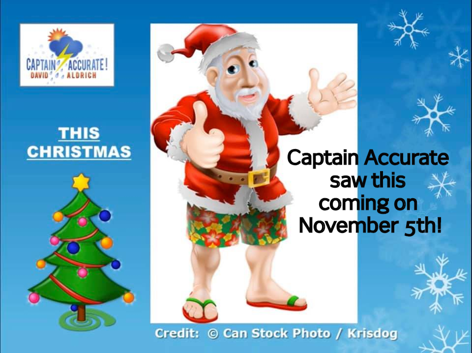 It's FREE. Just search: Captain Accurate at the App Store and Google Play Knoxville's low and high on Thursday: 24° and 45° With the Winter Solstice coming up on Saturday, we are quickly approaching the SHORTEST day and LONGEST NIGHT of the YEAR. Say hello to winter on Saturday, December 21st at 11:19 PM EST, astronomically speaking. Re: Rain Chances on Sunday Southern storm should bring some rain in on Sunday and lingering into the first half of Monday. The center of this rainmaker should roll from Destin, FL to Myrtle Beach, SC, bringing some Gulf of Mexico moisture into East Tennessee. The bulk of this rain, however, should stay south of our area into Georgia and the Carolinas. Tonight: Starry skies, frosty cold by morning, lows in the mid to upper 20s. Sunrise 7:42 AM Friday: Hazy sunshine due to high thin clouds, a bit milder, highs in the lower 50s Sunset 5:25 PM Friday night: Clouds thicken, lows in the lower to mid-30s. Saturday: Mostly cloudy, drizzle possible late, highs in the lower to mid-50s Saturday night: Mostly cloudy, spotty rain possible, lows in the upper 30s. Sunday: Cloudy skies, rain showers, 40% chance, highs around 50°. Sunday night: Cloudy, rain showers, 80% chance, lows in the upper 30s. Monday: Lingering morning showers fade, 60% chance, clouds to some sun, highs in the mid to upper 50s Christmas Eve: Sunny, highs in the lower 60s Christmas Day: Sunny, highs in the lower to mid-60s Normal high for Christmas in Knoxville: 48° Record high for Christmas in Knoxville: 76° (1982) This warm Christmas outlook was first presented on November 5th during my Winter Weather Outlook. To see that video for the rest of this upcoming winter, go to the Home page of CaptainAccurate.com, scroll down a bit, then hit PLAY. It's not easy being Accurate #CaptAccurateWx P.S. Here's your chance to make a statement, East Tennessee. If you find these independent forecasts helpful, please consider downloading my NEW Captain Accurate Weather App. It's FREE. ( And it keeps me in business :-) ) Just search: Captain Accurate at the App Store and Google Play. It comes with 5 FREE App Tutorials, so you can quickly learn all the wonderful things it can do. And Merry Christmas! It's FREE. Just search: Captain Accuate at the App Store and Google Play Wednesday's morning low and afternoon high in Knoxville was 26° and 44°. Tonight: Mostly clear and frosty cold by morning, lows in the lower to mid 20s. Sunrise 7:41 AM Thursday: Wall to wall sunshine, chilly, highs in the mid to upper 40s Sunset 5:25 PM Thursday night: Mostly clear, cold, lows in the upper 20s. Friday: Hazy sun, high clouds, highs in the lower 50s Saturday Mostly cloudy, spotty rain late, highs in the lower 50s. Sunday Cloudy, rain showers, 60% chance, highs around 50° Rain should linger into the first half of Monday, as temperatures warm up. Looking ahead to Christmas Eve & Christmas Day: 60° to 65° for highs, plenty of sunshine, warm, NO White Christmas...as first indicated on November 5th during my Winter Weather Outlook. To see that video for the rest of this upcoming winter, go to the Home page of CaptainAccurate.com, scroll down a bit, then hit PLAY. It's not easy being Accurate #CaptAccurateWx P.S. Here's your chance to make a statement, East Tennessee. If you find these independent forecasts helpful, please consider downloading my NEW Captain Accurate Weather App. It's FREE. ( And it keeps me in business :-) ) Just search: Captain Accurate at the App Store and Google Play. It comes with 5 FREE App Tutorials, so you can quickly learn all the wonderful things it can do. And Merry Christmas!  From my November 5th Winter Weather Outlook found on the Home page of CaptainAccurate.com It's FREE. Just search: Captain Accurate on the App Store and Google Play Tonight: Decreasing clouds, colder, patchy (freezing) fog early, lows in the mid to upper 20s. Sunrise 7:40 AM What is Freezing Fog? Click here: Wednesday: Sunshiny and chilly, highs in the mid-40s Sunset 5:25 PM Wednesday night: Mostly clear, colder, lows in the mid-20s. Thursday: Wall to wall sunshine, seasonably cold, highs in the upper-40s. So weather does not surprise you #CaptAccurateWx  It's FREE at the App Store and Google Play. Just search: Captain Accurate Get READY for a Free Fall. A Temperature FREE FALL today from 60° to 40° in about 9 hours. And even COLDER for the Plateau & Smokies. In summary, expect Mainly gray skies today. Leftover showers and sprinkles. Snowflakes for parts of the Smokies and Plateau. FALLING through the 50s early in the morning and ending the day in the upper 30s to around 40°, thanks to the passage of a cold front. I call that an "Upside Down" day. For example, Valley expectation: 7 AM near 60° Noon near 45° 4 PM near 40° Even COLDER in the Plateau & Smokies *** The peaks in the Smokies above 3,000 feet could receive 1" or more of snow. Tonight: Decreasing clouds, colder...lows in the mid to upper 20s Wednesday: Early fog, sunshiny skies, chilly...highs in the mid-40s Hope this helps you plan #CaptAccurateWx https://www.spc.noaa.gov/climo/reports/191216_rpts.html 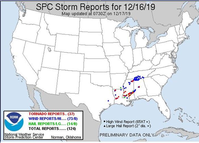 From the Storm Prediction Center 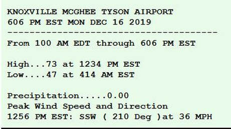 From NWS-Morristown Well, Knoxville officially broke a Record high today. 73° for 2019 beats 71° from 1929. It was a 90 year old record, dating back when Herbert Hoover was in the White House. Meanwhile, I was calling for gusts today to be between 35 and 40 mph. McGhee Tyson Airport recorded a 36 mph wind gust at 12:56 PM. Tonight: Rainy downpours, 1.0 to 1.5" expected with locally higher amounts. BIG puddles, isolated thunderstorms with strong to severe storms in the Plateau and around Chattanooga, warm, lows generally holding in the upper 50s to around 60 degrees until sunrise (7:40 AM). Tuesday: Morning showers, especially. Otherwise, mostly cloudy. FALLING through the 50s early in the morning and ending the day in the upper 30s to around 40°, thanks to the passage of a cold front. Tuesday night: Decreasing clouds, COLDER, lows in the upper 20s. Wednesday: Sunshiny skies, bright and chilly, highs in the mid-40s. It's not easy being Accurate #CaptAccurateWx https://www.spc.noaa.gov/products/outlook/day1otlk.html 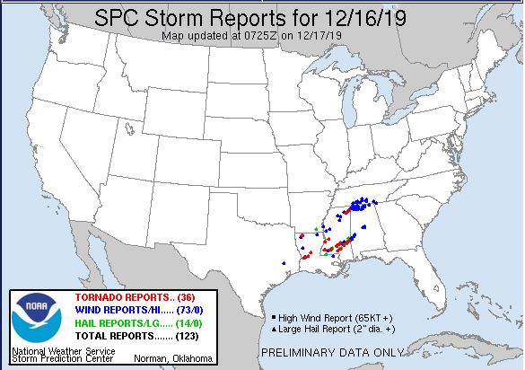 From the Storm Prediction Center 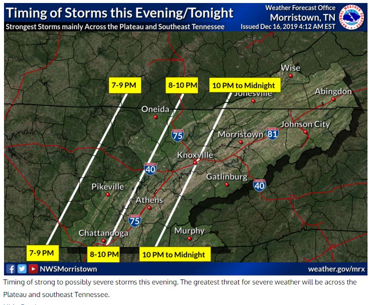 From NWS-Morristown First things first... Spotty rain on Monday is possible. No big deal. However, we got some moderate to heavy rain coming in THIS EVENING and lasting until Tuesday morning. A Valley start time of 7 PM to 9 PM Monday seems reasonable to me, as it comes in from West to East. It will be very easy to track using the Captain Accurate Weather App. (Psst! It's FREE at the App Store & Google Play. Just search: Captain Accurate) The start time for the Plateau and Southeast Kentucky will occur much sooner...the Smokies, a little bit later. Future Rainfall for Monday into Tuesday Model A...1.09" Model B...0.83" Model C...0.81" Average of the 3 Models: 0.91" Just so you know... At the end of last year, it was announced by the National Weather Service in Morristown that 2018 was the 8th Wettest year on record for Knoxville, dating back to 1871, when records for Knoxville began. The next day or so, TVA made the bold announcement that 2018 was, in fact, the Wettest year ever for much of East Tennessee (and they were including in that assessment the soggy year for Mt. Mitchell in North Carolina as part of their summary). For headline seekers, I'll let you guess which one was circulated the most. You guessed it: "Wettest Year Ever." But if you look, like I do, a little closer at the numbers, you would quickly realize that TVA did not begin until May 13th, 1933. At the time, FOUR of the TOP 8 Wettest Years were in the 1880s, which would have been outside the purview of the TVA. Thus, both headlines were correct. But it may have been more honest to circulate and say, 2018 was the Wettest year ever since 1933, according to TVA records. You see, the National Weather Service in Morristown has 147 years of Knoxville records. The Tennessee Valley Authority (TVA), founded by FDR and George W. Norris, has 85 years of records (since 1933). Hard to compare apples with oranges sometimes, don't you think? Average Yearly Rainfall for Knoxville: 47.86" (1981-2010) Highest rainfall total in one day: 6.14"...July 16, 1917 Highest rainfall total in one month: 17.62"...April 1874 TOP 10 WETTEST YEARS on Record for Knoxville 1). 73.77"...1875 2). 69.35"...2013 3). 66.36"...1882 4). 63.27"...1994 5). 62.53"...1884 6). 61.98"...2019 <----Now 7). 61.49"...1957 8). 61.45"...1886 9). 61.37"...2018 10). 60.66"...2009 Credit: NWS-Morristown Of course, looking back at this year, February 2019 certainly TIPPED THE SCALES with over 13 inches of rain, SOGGIEST February on record, during the shortest month of the year. In September 2019, the weather pendulum swung the other way with drought-like conditions and Knoxville only received 0.03" of rain...giving us the DRIEST September on record. It's kinda like going to the beach. February was HIGH tide, September was LOW tide. Sometimes that's how Nature works. Knoxville's Rain (and Melted Snow) in 2019 @ McGhee Tyson Airport Jan. 4.98" Feb. 13.08" Mar. 4.05" Apr. 4.39" May 5.70" Jun. 7.02" Jul. 5.88" Aug. 3.13" Sep. 0.03" Oct. 4.96" Nov. 6.11" Dec. 1st-15th 2.65" so far... TOTAL: 61.98" SO FAR... #CaptAccurateWx 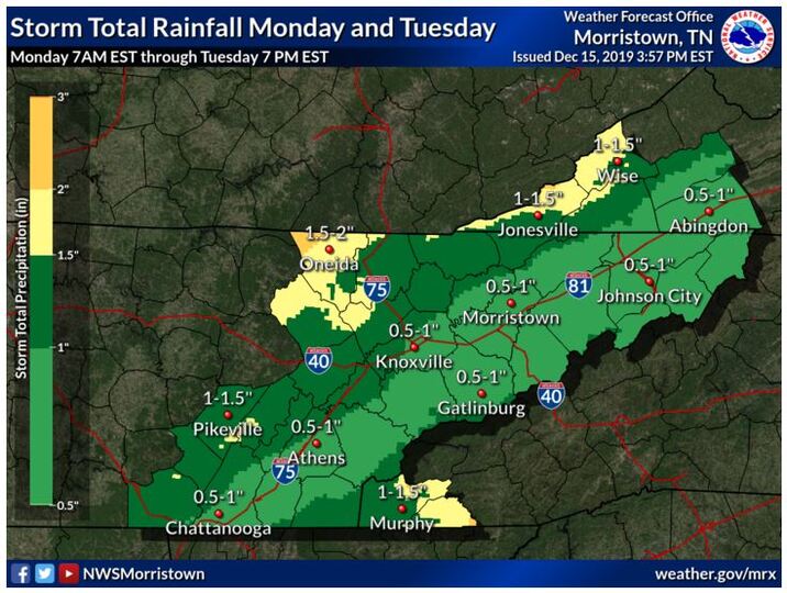 From NWS-Morristown |
David AldrichCaptain Accurate Weather Archives
April 2024
Categories |
 RSS Feed